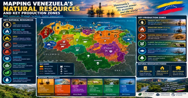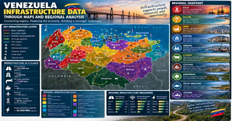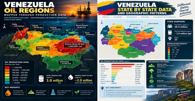
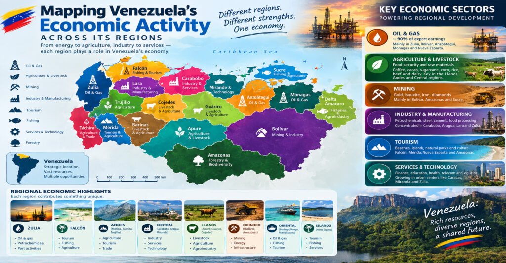
Venezuela’s economy is closely tied to its geography.
Oil fields are not spread evenly across the country. Farms are concentrated in areas with the right soil, rainfall, and roads. Mining is strongly linked to the mineral-rich south. Manufacturing is concentrated around major cities and transport routes. Ports connect coastal areas with international trade, while rivers and highways link the interior with markets.
This makes a regional view useful.
Mapping Venezuela’s Economic Activity Across Its Regions helps explain why one part of the country may depend on oil while another depends on farming, mining, manufacturing, tourism, trade, or services.
Venezuela has 23 states, the Capital District, and federal dependencies. Each area has a different mix of land, people, resources, infrastructure, and economic activity.
The country’s economic map can therefore be read as a set of connected zones rather than one single national economy.
The most important patterns include the following:
- Western Venezuela has a long history of petroleum, agriculture, trade, and border commerce.
- Central Venezuela has a high concentration of people, industry, services, and transportation.
- The Llanos are strongly linked to cattle, crops, rivers, and rural production.
- Eastern Venezuela contains major oil and gas activity, ports, agriculture, and coastal cities.
- Southern Venezuela has major mineral, hydro power, forest, and tourism resources.
- Island and coastal regions depend heavily on ports, fishing, tourism, trade, and services.
- Caracas and nearby areas form the country’s strongest concentration of government, business, and services.
Understanding these patterns makes economic data easier to read.
It also shows why a national number can hide major differences between regions.
Mapping Venezuela’s Economic Activity Across Its Regions: The Big Picture
Venezuela has one of the largest petroleum resource bases in the world, but oil is only one part of the country’s economic geography.
Agriculture, mining, manufacturing, transportation, commerce, construction, tourism, and public services all play important roles.
The size of each sector varies by location.
The World Bank’s recent national data show that Venezuela’s economy remains much smaller than it was during earlier periods of high oil income, while national economic conditions have changed significantly over time. Recent figures also show that population, migration, and economic output continue to shift. For that reason, regional analysis should always identify the year of the data being used.
A map helps put those numbers into context.
The main economic regions
For a simple geographic view, Venezuela can be divided into several broad economic zones:
- Western Venezuela: petroleum, agriculture, commerce, manufacturing, and border trade.
- Central Venezuela: manufacturing, services, finance, commerce, government, and transportation.
- The Llanos: livestock, crops, energy, and rural production.
- Eastern Venezuela: oil, gas, ports, agriculture, fishing, and services.
- Southern Venezuela: mining, hydropower, forestry, tourism, and Indigenous economies.
- Caribbean and island areas: tourism, fishing, ports, commerce, and services.
These are broad patterns, not official economic regions.
A state can belong to more than one economic system.
Mapping Venezuela’s Economic Activity Across Its Regions With State Data
Venezuela’s states provide a useful starting point for economic mapping.
| State | Capital | Major economic patterns |
|---|---|---|
| Amazonas | Puerto Ayacucho | Forestry-related activity, tourism, river trade, local economies |
| Anzoátegui | Barcelona | Oil, gas, ports, tourism, services, agriculture |
| Apure | San Fernando de Apure | Cattle, agriculture, fishing, rural trade |
| Aragua | Maracay | Manufacturing, agriculture, commerce, services |
| Barinas | Barinas | Agriculture, cattle, oil, commerce |
| Bolívar | Ciudad Bolívar | Mining, hydropower, heavy industry, tourism |
| Carabobo | Valencia | Manufacturing, logistics, commerce, ports |
| Cojedes | San Carlos | Agriculture, cattle, food production |
| Delta Amacuro | Tucupita | Fishing, river trade, agriculture, local services |
| Falcón | Coro | Oil refining, ports, tourism, agriculture |
| Guárico | San Juan de los Morros | Agriculture, cattle, oil, energy |
| Lara | Barquisimeto | Commerce, agriculture, manufacturing, services |
| Mérida | Mérida | Agriculture, tourism, services |
| Miranda | Los Teques | Services, commerce, manufacturing, urban economy |
| Monagas | Maturín | Oil, gas, agriculture, services |
| Nueva Esparta | La Asunción | Tourism, fishing, commerce, services |
| Portuguesa | Guanare | Crops, food production, agriculture |
| Sucre | Cumaná | Fishing, agriculture, tourism, ports |
| Táchira | San Cristóbal | Agriculture, manufacturing, commerce, border trade |
| Trujillo | Trujillo | Agriculture, livestock, commerce, tourism |
| La Guaira | La Guaira | Ports, logistics, tourism, services |
| Yaracuy | San Felipe | Agriculture, food processing, commerce |
| Zulia | Maracaibo | Oil, agriculture, trade, manufacturing, services |
The table is a broad guide rather than a ranking.
Economic activity can change over time, and a single state may contain several different local economies.
Mapping Venezuela’s Economic Activity Across Its Regions: Why Geography Matters
Economic activity follows geography in several ways.
A factory needs roads, electricity, workers, suppliers, and customers.
A farm needs suitable land, water, climate, labor, and transport.
An oil field needs wells, pipelines, processing equipment, storage, roads, ports, and technical services.
A mine needs access to the deposit, power, transport, workers, processing facilities, and markets.
A tourist destination needs natural or cultural attractions plus hotels, roads, airports, restaurants, and other services.
This means economic geography is really about connections.
A resource alone does not create a complete economy.
The surrounding infrastructure and people matter too.
Mapping Venezuela’s Economic Activity Across Its Regions: Oil and Energy
Oil remains the most important part of Venezuela’s resource geography.
The country had about 303 billion barrels of proved crude oil reserves in 2023 according to international energy data, with most of those reserves consisting of extra-heavy crude in the Orinoco Oil Belt.
That figure describes reserves, not annual production.
This difference matters.
A country can have very large reserves while producing much less oil than its resource base might suggest.
Where is Venezuela’s oil concentrated?
The two major petroleum areas are:
- The Maracaibo Basin in western Venezuela.
- The Eastern Venezuela Basin, including the large Orinoco petroleum region.
Oil activity also affects states beyond the immediate location of a producing field.
Pipelines may cross several states.
Refineries may be far from oil fields.
Ports may be used to export crude or refined products.
Service companies may operate from cities outside the production area.
This creates a large economic network.
Mapping Venezuela’s Economic Activity Across Its Regions: The Maracaibo Basin
The Maracaibo Basin is one of Venezuela’s oldest and best-known oil-producing regions.
It is centered around Lake Maracaibo and surrounding areas of Zulia.
Oil development in the region helped transform communities such as Maracaibo, Cabimas, Lagunillas, and other towns.
The economic system includes much more than drilling.
It includes:
- Oil wells.
- Pipelines.
- Storage facilities.
- Ports.
- Roads.
- Oilfield services.
- Equipment suppliers.
- Refineries.
- Housing.
- Retail businesses.
- Public services.
This is why the oil industry can affect a region far beyond the boundaries of an oil field.
Zulia’s wider economy
Zulia is not only an oil state.
It also has:
- Agriculture.
- Cattle production.
- Dairy activity.
- Fishing.
- Manufacturing.
- Retail trade.
- Transportation.
- Services.
The state therefore has a mixed economy built around Lake Maracaibo, cities, farms, energy, and trade.
Mapping Venezuela’s Economic Activity Across Its Regions: The Orinoco Oil Belt
The Orinoco Oil Belt is one of the defining features of Venezuela’s modern energy map.
It stretches across a large area south of the Orinoco River.
The oil is generally extra-heavy, which means it has a much higher density and viscosity than many lighter crude oils.
Extra-heavy oil creates special production and processing needs.
It may require:
- Specialized production methods.
- Dilution or upgrading.
- Heated or specialized handling.
- Suitable pipelines.
- Specialized refining capacity.
- Large amounts of technical support.
The Orinoco area has traditionally been divided into major development zones commonly known as Boyacá, Junín, Ayacucho, and Carabobo.
These divisions are useful for understanding petroleum development but should not be confused with Venezuela’s state boundaries.
Mapping Venezuela’s Economic Activity Across Its Regions: Eastern Energy
Monagas and Anzoátegui are central to eastern Venezuela’s energy geography.
Maturín became an important energy and service center because of nearby petroleum activity.
Anzoátegui also has major energy infrastructure and important coastal facilities.
The region connects inland production with processing, storage, transport, and export systems.
This creates a chain:
Oil and gas fields → pipelines → processing → storage → ports → markets
Each part of the chain supports jobs and services.
Mapping Venezuela’s Economic Activity Across Its Regions: Refining
Oil production and oil refining are different activities.
Venezuela has major refining infrastructure in several areas.
Important facilities include:
- Amuay.
- Cardón.
- Puerto La Cruz.
- El Palito.
The large refining complex in the Paraguaná area of Falcón is especially important to Venezuela’s downstream petroleum system.
Refineries turn crude oil into products such as gasoline, diesel, jet fuel, and other petroleum products.
This means Falcón has an economic role that is different from a state where crude is mainly extracted.
Mapping Venezuela’s Economic Activity Across Its Regions: Oil Services
Oil production supports a wide network of businesses.
These can include:
- Drilling services.
- Engineering.
- Equipment maintenance.
- Transportation.
- Welding.
- Construction.
- Safety services.
- Catering.
- Warehousing.
- Technical training.
When oil production falls, these supporting activities can also be affected.
When investment increases, demand for these services can rise.
This is one reason production data should not be viewed alone.
Mapping Venezuela’s Economic Activity Across Its Regions: Agriculture
Agriculture creates a second major economic geography.
The country’s farming regions are shaped by rainfall, soil, elevation, irrigation, roads, markets, and climate.
The central-western plains are especially important for grain production.
Recent agricultural reporting identifies Portuguesa, Guárico, and Barinas as major maize-producing areas, while Portuguesa, Guárico, and Cojedes are important rice-producing regions.
This shows why the western and central plains matter to food production.
Major agricultural patterns
Different regions specialize in different products.
- Portuguesa: grains and large-scale agriculture.
- Guárico: grains, rice, cattle, and other crops.
- Barinas: crops, cattle, and mixed agriculture.
- Cojedes: cattle and crop production.
- Lara: vegetables, fruits, livestock, and dry-region farming.
- Mérida: mountain agriculture and horticulture.
- Táchira: coffee, vegetables, livestock, and other crops.
- Trujillo: mountain and valley agriculture.
- Zulia: cattle, dairy, crops, and fishing.
The exact production mix changes with market conditions and weather.
Mapping Venezuela’s Economic Activity Across Its Regions: The Llanos
The Llanos are one of Venezuela’s most important agricultural landscapes.
They cover large parts of central Venezuela.
The land is generally flat, although local landscapes vary.
Cattle raising has a long history in the region.
Agriculture has also grown in areas with suitable soils, irrigation, roads, and farm services.
The Llanos include parts of:
- Apure.
- Barinas.
- Cojedes.
- Guárico.
- Portuguesa.
The region is therefore important to both livestock and crop production.
Why the Llanos are useful for economic mapping
The Llanos show how physical geography affects economic activity.
Flat land makes some forms of mechanized agriculture easier.
Large open areas support cattle.
Rivers provide water but can also cause flooding.
Roads connect farms with cities and processing centers.
The economy is therefore shaped by both opportunity and seasonal risk.
Mapping Venezuela’s Economic Activity Across Its Regions: Portuguesa
Portuguesa is one of the strongest examples of agricultural specialization.
The state is widely associated with large-scale crop production.
Guanare is the state capital, while Acarigua and Araure form an important urban and agricultural center.
The area has strong links to:
- Grain farming.
- Food processing.
- Agricultural machinery.
- Storage.
- Transportation.
- Farm services.
A farm economy creates demand far beyond the farm itself.
Farmers need seeds, fertilizer, machinery, fuel, repairs, storage, transport, and buyers.
That creates a wider agricultural business network.
Mapping Venezuela’s Economic Activity Across Its Regions: Guárico
Guárico covers a large area of the central plains.
Agriculture and cattle remain important.
The state also has petroleum resources.
Its position between central cities and the Llanos gives it a useful transport role.
Economic activity can therefore shift across the state depending on location.
Northern areas may be more connected to central markets, while southern areas have stronger rural and livestock patterns.
Mapping Venezuela’s Economic Activity Across Its Regions: Barinas
Barinas sits between the Andes and Llanos.
This gives it a mixed economic identity.
The state has:
- Agriculture.
- Cattle.
- Oil activity.
- Food processing.
- Trade.
- Services.
Its capital, Barinas, acts as a regional center.
The surrounding agricultural areas supply products to urban markets.
Mapping Venezuela’s Economic Activity Across Its Regions: Manufacturing
Manufacturing is strongly concentrated in the northern and central parts of Venezuela.
This pattern has deep historical roots.
Factories tend to cluster where there are:
- Large markets.
- Roads.
- Ports.
- Electricity.
- Workers.
- Suppliers.
- Financial services.
- Existing industrial networks.
This helps explain the importance of states such as Carabobo, Aragua, Miranda, and parts of Lara and Zulia.
Mapping Venezuela’s Economic Activity Across Its Regions: Carabobo
Carabobo is one of the country’s strongest industrial areas.
Valencia is its main urban and industrial center.
The state also has access to Puerto Cabello, one of Venezuela’s major ports.
This creates a strong combination:
City + factories + roads + port + workers + markets
Manufacturing has included areas such as food, chemicals, metal products, machinery, and automotive-related production.
Carabobo’s economic importance is therefore much larger than its small land area might suggest.
Mapping Venezuela’s Economic Activity Across Its Regions: Aragua
Aragua is another major central industrial state.
Maracay is a major urban center.
The state benefits from its location between Caracas and western-central Venezuela.
Its economy includes:
- Manufacturing.
- Agriculture.
- Food processing.
- Commerce.
- Services.
- Logistics.
The surrounding valleys also support agriculture.
This combination of farms and factories creates strong local economic links.
Mapping Venezuela’s Economic Activity Across Its Regions: Miranda
Miranda has one of the country’s most service-oriented economic landscapes.
Its proximity to Caracas is a major advantage.
Economic activity includes:
- Retail.
- Business services.
- Manufacturing.
- Food production.
- Transportation.
- Communications.
- Construction.
- Professional services.
Cities and suburbs form a large connected metropolitan system.
The economic boundary therefore does not stop at the state line.
People may live in Miranda, work in Caracas, shop in another municipality, and use transport facilities in La Guaira.
Mapping Venezuela’s Economic Activity Across Its Regions: Caracas
Caracas is the center of Venezuela’s national government.
It is also a major center for:
- Banking.
- Business services.
- Education.
- Media.
- Healthcare.
- Retail.
- Professional services.
- Construction.
- Technology and communications.
The city does not contain large oil fields or huge agricultural areas.
Its economic role comes mainly from concentration.
People, institutions, businesses, and services are close together.
That concentration creates economic power even when physical resource production occurs elsewhere.
Mapping Venezuela’s Economic Activity Across Its Regions: Lara
Lara has a different economic pattern.
Barquisimeto is a major commercial center.
The city connects agricultural regions with western and central markets.
The state also has manufacturing and food-processing activity.
Its dry climate creates agricultural challenges, but irrigation and suitable crops support farming.
Lara is therefore an example of a state where trade and agriculture reinforce each other.
Mapping Venezuela’s Economic Activity Across Its Regions: Bolívar
Bolívar has one of the most distinctive economic profiles in Venezuela.
The state contains major mineral deposits, huge rivers, hydropower infrastructure, forests, and industrial cities.
Its major activities include:
- Iron ore.
- Gold.
- Bauxite.
- Hydropower.
- Metal industries.
- Heavy industry.
- Tourism.
- Local commerce.
Ciudad Guayana
Ciudad Guayana is especially important.
The city developed around industrial activity, hydropower, transportation, and mineral resources.
Its location near the Caroní and Orinoco river systems gives it a strong geographic advantage.
Mining and industry
Mineral extraction is only the first step.
The broader economic system may include:
Mine → transport → processing → manufacturing → port or domestic market
That chain creates a larger economic footprint than the mine alone.
Mapping Venezuela’s Economic Activity Across Its Regions: Hydropower
Venezuela’s hydropower geography is strongly linked to the Caroní River in Bolívar.
Large hydropower projects in the region have supplied electricity to cities and industries.
Energy availability helped support industrial development in the Guayana region.
This demonstrates an important economic geography rule:
Resources become more valuable when infrastructure connects them to production.
A river can provide water.
A dam can create electricity.
Electricity can support factories.
Factories create jobs.
Jobs support cities.
Cities create demand for services.
One geographic feature can therefore influence an entire regional economy.
Mapping Venezuela’s Economic Activity Across Its Regions: Mining
Mining is concentrated in southern Venezuela.
Bolívar is especially important for:
- Iron ore.
- Gold.
- Bauxite.
- Other minerals.
Mining also occurs elsewhere.
The economic value of mining must be considered alongside environmental and social effects.
Unregulated or informal mining can damage forests and rivers.
It can also create pressure on Indigenous territories.
A complete economic map should therefore show both resource areas and sensitive environmental zones.
Mapping Venezuela’s Economic Activity Across Its Regions: Amazonas
Amazonas is one of Venezuela’s largest states by area but has a relatively small population.
Its economy is very different from the industrial north.
Important activities include:
- Local agriculture.
- Fishing.
- River transport.
- Small-scale trade.
- Tourism.
- Public services.
- Indigenous community economies.
The state has extensive forests and river systems.
Tourism based on natural landscapes can provide income without requiring dense industrial development, although access and infrastructure remain important limits.
Mapping Venezuela’s Economic Activity Across Its Regions: Delta Amacuro
Delta Amacuro is shaped by the Orinoco Delta.
Waterways dominate much of the landscape.
Fishing, small-scale agriculture, river transport, trade, and public services are important to local communities.
The Warao people have deep connections to the delta environment.
Economic activity here cannot be understood through roads and factories alone.
Rivers are part of the transport network.
Wetlands are part of the natural resource system.
Communities are closely connected to water.
Mapping Venezuela’s Economic Activity Across Its Regions: Anzoátegui
Anzoátegui combines energy, coastal trade, tourism, services, and agriculture.
Barcelona and Puerto La Cruz form a major urban area.
The state has important oil and gas infrastructure.
Its coast also provides access to ports and tourism.
The state’s economy therefore links inland energy production with coastal transport.
Mapping Venezuela’s Economic Activity Across Its Regions: Monagas
Monagas is one of the most important eastern energy states.
Maturín developed as a major service center for surrounding oil-producing areas.
Oil and gas activity creates demand for:
- Engineering.
- Transportation.
- Housing.
- Food services.
- Equipment.
- Construction.
- Professional services.
Agriculture and livestock are also important.
This creates a mixed economy rather than a single-industry landscape.
Mapping Venezuela’s Economic Activity Across Its Regions: Sucre
Sucre is strongly connected to the sea.
Fishing is an important traditional activity.
The state also has:
- Agriculture.
- Tourism.
- Ports.
- Commerce.
- Services.
Cumaná is a major coastal city.
The Gulf of Cariaco and surrounding Caribbean waters shape local economic life.
Tourism has potential because of beaches, natural areas, and cultural heritage.
Mapping Venezuela’s Economic Activity Across Its Regions: Falcón
Falcón is economically diverse.
The state is known for petroleum refining, coastal trade, tourism, agriculture, and fisheries.
The Paraguaná Peninsula is particularly important because of its refining infrastructure.
Coro is another major center, with historical and tourism value.
The state also includes dry landscapes that create special agricultural conditions.
Mapping Venezuela’s Economic Activity Across Its Regions: La Guaira
La Guaira is a small coastal state with major economic importance because of its position next to Caracas.
Its economy is closely linked to:
- Ports.
- Air transport.
- Logistics.
- Tourism.
- Trade.
- Services.
The state’s narrow geography creates a strong connection between the mountains and Caribbean coast.
The port system and airport serve the wider capital region.
Mapping Venezuela’s Economic Activity Across Its Regions: Nueva Esparta
Nueva Esparta has an island economy.
Tourism is a major part of its economic identity.
Margarita Island is known for beaches, hotels, restaurants, shopping, and tourism services.
Other activities include fishing and local commerce.
Island economies face a special challenge.
They depend heavily on transport links for goods, fuel, visitors, and investment.
Mapping Venezuela’s Economic Activity Across Its Regions: Táchira
Táchira has a strategic location on the Colombian border.
San Cristóbal is its main urban center.
The state combines:
- Agriculture.
- Manufacturing.
- Commerce.
- Services.
- Transportation.
- Border trade.
Its mountainous terrain affects transport.
At the same time, the international border creates opportunities for trade and commerce.
This makes Táchira different from an inland agricultural state with no international border.
Mapping Venezuela’s Economic Activity Across Its Regions: Mérida
Mérida has a strong mountain economy.
Agriculture is important in suitable valleys.
Tourism is also a major part of the regional economy.
The state’s high mountains attract visitors interested in:
- Hiking.
- Nature.
- Cool weather.
- Mountain landscapes.
- Historic towns.
Services related to tourism can support hotels, restaurants, transportation, guides, and local businesses.
Mapping Venezuela’s Economic Activity Across Its Regions: Trujillo
Trujillo is another Andean state.
Agriculture is shaped by altitude and valley geography.
Livestock and farming are important.
Tourism also benefits from the state’s mountain landscapes and cultural heritage.
The state shows how smaller mountain economies can depend on a mix of agriculture, local trade, and services.
Mapping Venezuela’s Economic Activity Across Its Regions: Yaracuy
Yaracuy lies in a productive transition zone between mountains and central Venezuela.
Agriculture is important.
Food processing and local commerce also benefit from the agricultural base.
San Felipe serves as the state capital and a regional service center.
The state’s location makes it useful for moving agricultural products toward larger markets.
Mapping Venezuela’s Economic Activity Across Its Regions: Apure
Apure is strongly associated with cattle and the Llanos.
Its large area contains relatively few major urban centers.
Economic activity is spread across rural communities and agricultural areas.
Fishing and river systems are also important.
The state’s geographic challenge is distance.
Moving products from remote farms to markets requires reliable roads, bridges, fuel, storage, and transport services.
Mapping Venezuela’s Economic Activity Across Its Regions: Cojedes
Cojedes has a strong agricultural identity.
Its economy includes:
- Cattle.
- Crops.
- Food processing.
- Rural commerce.
- Services.
The state benefits from its location in central Venezuela.
It is close enough to major markets to connect agricultural production with large urban populations.
Mapping Venezuela’s Economic Activity Across Its Regions: Zulia
Zulia is one of the most economically important states in western Venezuela.
Its economic geography is built around several systems.
Petroleum
The Lake Maracaibo basin has a long petroleum history.
Agriculture
Zulia has major cattle and dairy areas.
Cities
Maracaibo is a major commercial and service center.
Trade
The state’s western position gives it connections with Colombia and the Caribbean.
Manufacturing
Food processing and other industrial activities support the regional economy.
Zulia therefore cannot be described as only an oil region.
It is a large mixed economic system.
Mapping Venezuela’s Economic Activity Across Its Regions: Trade
Trade depends on geography.
Goods must move from farms, mines, factories, and oil fields to consumers or export points.
That creates several important transport corridors.
Central trade corridor
Caracas, Miranda, Aragua, and Carabobo form a highly connected central economic zone.
Western corridor
Lara, Zulia, and other western states connect agricultural production, cities, ports, and border markets.
Eastern corridor
Anzoátegui and Monagas connect energy production with coastal infrastructure.
Southern corridor
Bolívar connects mines, industrial centers, rivers, and energy systems.
Mapping Venezuela’s Economic Activity Across Its Regions: Ports
Ports are a key part of Venezuela’s economic map.
Important port areas include:
- La Guaira.
- Puerto Cabello.
- Maracaibo.
- Puerto La Cruz.
- Other Caribbean and eastern facilities.
A port’s value depends on its connection to inland production.
A port without roads, storage, or reliable cargo systems cannot fully serve a regional economy.
This is why ports should always be mapped with highways, industrial centers, cities, and production areas.
Mapping Venezuela’s Economic Activity Across Its Regions: Airports
Airports support business, tourism, trade, and regional connections.
The Caracas metropolitan area has major international air connections through the airport near Maiquetía.
Other large cities have airports serving regional traffic.
Remote areas depend more heavily on smaller airports and river transport.
This difference matters when measuring regional access.
Mapping Venezuela’s Economic Activity Across Its Regions: Roads
Roads connect economic activity.
Agricultural areas need roads to move crops.
Mines need roads to move ore and supplies.
Cities need roads to move workers and goods.
Ports need roads to connect cargo with inland producers.
The quality and reliability of these connections can strongly affect regional economic performance.
Mapping Venezuela’s Economic Activity Across Its Regions: Services
Services are often overlooked because they are less visible than oil wells, factories, or farms.
But services are a large part of modern urban economies.
They include:
- Retail.
- Banking.
- Education.
- Health care.
- Restaurants.
- Hotels.
- Transportation.
- Communications.
- Legal services.
- Professional services.
- Government services.
These activities are concentrated in large cities.
That is why Caracas, Maracaibo, Valencia, Barquisimeto, Maracay, and other major urban centers have economic influence far beyond their physical size.
Mapping Venezuela’s Economic Activity Across Its Regions: Tourism
Tourism follows natural and cultural attractions.
Venezuela has several major tourism zones.
Caribbean tourism
Coastal states and islands offer beaches and marine activities.
Mountain tourism
Mérida and other Andean states offer mountain scenery and cooler climates.
Nature tourism
Bolívar and Amazonas offer forests, rivers, tepuis, and waterfalls.
Historic tourism
Coro and other historic cities provide cultural attractions.
Urban tourism
Caracas and major cities offer museums, restaurants, shopping, cultural events, and business travel.
Tourism therefore creates another layer on the economic map.
Mapping Venezuela’s Economic Activity Across Its Regions: Natural Resources
Natural resources are unevenly distributed.
Petroleum
Strongly associated with Zulia and eastern Venezuela.
Minerals
Strongly associated with Bolívar and the Guiana Shield.
Hydropower
Strongly associated with the Caroní River in Bolívar.
Agriculture
Spread across the Llanos, western valleys, Andean regions, and other suitable areas.
Fisheries
Important along the Caribbean coast, Lake Maracaibo, rivers, and island areas.
Forests
Extensive forest areas occur in southern Venezuela.
Each resource creates a different economic network.
Mapping Venezuela’s Economic Activity Across Its Regions: Agriculture Versus Oil
The contrast between agriculture and oil is useful.
Oil can generate very high economic value from a relatively small number of production sites.
Agriculture uses much larger areas of land and often supports more dispersed communities.
A petroleum region may have pipelines, industrial facilities, and specialized workers.
An agricultural region may have farms, roads, grain silos, livestock facilities, food processors, and rural markets.
Both are important, but they create very different landscapes.
Mapping Venezuela’s Economic Activity Across Its Regions: Urban Concentration
Economic activity often follows population.
Large populations create demand for:
- Food.
- Housing.
- Transport.
- Education.
- Healthcare.
- Retail.
- Entertainment.
- Financial services.
This creates a feedback loop.
More people create more businesses.
More businesses create more jobs.
More jobs can attract more people.
This helps explain the economic importance of central Venezuela.
Mapping Venezuela’s Economic Activity Across Its Regions: Rural Economies
Rural economies operate differently.
A rural economy may be based on:
- Farming.
- Livestock.
- Fishing.
- Forestry.
- Small-scale trade.
- Local services.
Income may depend on seasonal conditions.
Rainfall, crop prices, fuel costs, and transportation can all affect rural households.
This is especially important in the Llanos and agricultural parts of western Venezuela.
Mapping Venezuela’s Economic Activity Across Its Regions: Informal Activity
Formal economic statistics do not capture every economic activity.
Small businesses, street commerce, family enterprises, informal transportation, and other activities may be difficult to measure.
This matters especially in places where official economic data are limited.
A map based only on registered businesses may therefore underestimate local economic activity.
Good regional analysis should acknowledge this limitation.
Mapping Venezuela’s Economic Activity Across Its Regions: Energy Infrastructure
Energy infrastructure connects several regions.
Oil production requires pipelines.
Refineries require crude supplies.
Factories require electricity.
Cities require power distribution.
Hydropower from Bolívar can support industrial and urban areas far beyond the immediate dam locations.
This creates a national energy network.
Economic activity should therefore be mapped together with energy infrastructure.
Mapping Venezuela’s Economic Activity Across Its Regions: Oil and Government Revenue
Venezuela’s petroleum sector has historically provided a very large share of government income and export earnings.
This means oil activity affects the wider economy even in states with little or no oil production.
When oil income changes, government spending can change.
That can affect:
- Construction.
- Public employment.
- Infrastructure.
- Social programs.
- Imports.
- Regional investment.
This is one reason Venezuela’s economic geography cannot be understood through state-level production alone.
Mapping Venezuela’s Economic Activity Across Its Regions: Why Production and Revenue Are Different
Oil production measures physical output.
Government revenue measures money received by the state.
Export value measures the value of goods sold abroad.
These are different measures.
For example, a rise in oil production does not automatically mean an equal rise in government revenue.
Prices, costs, taxes, contracts, export conditions, and other factors matter.
This is an important point when reading economic data.
Mapping Venezuela’s Economic Activity Across Its Regions: Current Economic Change
Venezuela’s economy has changed significantly over the last two decades.
Oil production declined sharply from earlier peaks.
Infrastructure and investment problems affected production capacity.
International restrictions have also affected access to technology, finance, equipment, and markets, while the effects differ by period and type of restriction.
More recently, some oil activity has recovered from very low levels, but production remains far below the country’s historical peaks.
The wider economy has also changed.
Some private businesses have expanded or adapted.
Urban commerce has changed.
Dollar use has become more visible in parts of the economy.
Migration has changed labor and household patterns.
These changes mean the economic map of Venezuela is not static.
Mapping Venezuela’s Economic Activity Across Its Regions: Agriculture in a Changing Economy
Agriculture has also changed.
Recent agricultural reporting indicates that production in important grain-producing states such as Portuguesa, Guárico, and Barinas remains below historical pre-crisis levels for some crops, although some areas have experienced recent increases.
Input costs matter.
Farmers may face higher costs for:
- Fuel.
- Seeds.
- Fertilizer.
- Machinery.
- Credit.
- Transport.
Weather is another major factor.
Floods can damage crops.
Drought can reduce yields.
Rain timing can change planting dates.
This means agricultural maps should be updated regularly.
Mapping Venezuela’s Economic Activity Across Its Regions: Climate Risk
Climate can affect economic activity in every region.
Flood risk
Important in the Llanos and river areas.
Landslides
Important in mountain regions.
Drought
Important in drier areas.
Coastal storms
Important along the Caribbean coast.
Extreme rainfall
Can damage roads, bridges, crops, and urban infrastructure.
Economic maps should therefore include environmental risk.
A road may appear on a map, but its real economic value depends on whether it remains usable during extreme weather.
Mapping Venezuela’s Economic Activity Across Its Regions: The Role of Water
Water is an economic resource.
It supports:
- Farming.
- Drinking water.
- Hydropower.
- Industry.
- Fishing.
- Tourism.
- Transportation.
The Orinoco and Caroní systems are particularly important.
Lake Maracaibo also has major economic significance.
Water geography therefore helps explain why some regions developed large agricultural or industrial systems.
Mapping Venezuela’s Economic Activity Across Its Regions: Environmental Limits
Economic activity can create environmental pressure.
Oil production can affect land and water.
Mining can cause forest loss and river pollution.
Agriculture can create pressure on soils and water supplies.
Urban growth can replace natural land.
Tourism can put pressure on fragile ecosystems.
A people-first economic map should include these costs.
Economic activity is not only about production.
It is also about how people live with the environment.
Mapping Venezuela’s Economic Activity Across Its Regions: Indigenous Economies
Indigenous communities play important roles in parts of southern and eastern Venezuela.
Economic activity may include:
- Fishing.
- Small-scale agriculture.
- Craft production.
- Forest products.
- Tourism.
- River transport.
These activities can be missed by national economic statistics.
This is especially important in Amazonas, Bolívar, and Delta Amacuro.
A complete regional economic map should not define an area only by large companies or government projects.
Mapping Venezuela’s Economic Activity Across Its Regions: Border Economies
Borders can create unique economic zones.
Táchira’s border with Colombia is a strong example.
Zulia and Apure also have border connections with Colombia.
Amazonas and Bolívar connect Venezuela with Brazil.
Border economies can involve:
- Trade.
- Transport.
- Retail.
- Agriculture.
- Tourism.
- Logistics.
- Currency exchange.
- Cross-border services.
Official trade data may not capture every small-scale transaction.
This is another reason local economic maps need more than one data source.
Mapping Venezuela’s Economic Activity Across Its Regions: Caracas and the Central Corridor
The central corridor is one of the strongest economic zones.
It includes Caracas and parts of Miranda, La Guaira, Aragua, and Carabobo.
Its strengths include:
- Large population.
- Government.
- Services.
- Manufacturing.
- Ports.
- Airports.
- Roads.
- Universities.
- Financial activity.
The area is also highly urbanized.
This concentration creates strong economic connections between neighboring states.
Mapping Venezuela’s Economic Activity Across Its Regions: Western Corridor
Western Venezuela has several overlapping economic systems.
Zulia is important for petroleum and agriculture.
Lara is a major commercial and agricultural center.
Táchira is important for border trade and agriculture.
Mérida and Trujillo have mountain economies.
Falcón combines refining, ports, tourism, and agriculture.
These states are different, but roads and markets connect them.
Mapping Venezuela’s Economic Activity Across Its Regions: Eastern Corridor
Eastern Venezuela has a strong energy identity.
Monagas and Anzoátegui are important to petroleum and natural gas.
Sucre adds fishing, tourism, agriculture, and coastal trade.
Delta Amacuro connects the region with the Orinoco Delta.
Ports are important because they connect inland energy and agricultural activity with the sea.
Mapping Venezuela’s Economic Activity Across Its Regions: Southern Corridor
Southern Venezuela is dominated by very large landscapes.
Bolívar is the main industrial and mining center.
Amazonas has a much lower population density and a stronger forest and river economy.
The southern economic system depends heavily on:
- Rivers.
- Electricity.
- Mining.
- Roads.
- Industrial cities.
- Tourism.
- Indigenous communities.
This region cannot be understood using the same model as Caracas or Valencia.
Mapping Venezuela’s Economic Activity Across Its Regions: Economic Hubs
An economic hub is a place where many activities meet.
Major Venezuelan hubs include:
- Caracas.
- Maracaibo.
- Valencia.
- Barquisimeto.
- Maracay.
- Ciudad Guayana.
- Maturín.
- Barcelona-Puerto La Cruz.
- San Cristóbal.
Each hub has a different economic role.
Caracas is strongest in government and services.
Valencia is strongly industrial.
Maracaibo is closely linked to western oil, agriculture, commerce, and services.
Ciudad Guayana is closely tied to mining, energy, and heavy industry.
Maturín is strongly linked to eastern energy activity.
Mapping Venezuela’s Economic Activity Across Its Regions: Economic Networks
The most useful way to understand Venezuela may be through networks rather than isolated states.
Consider a simple food chain:
Farm → road → storage → processing plant → city → consumer
Now consider oil:
Oil field → pipeline → storage → refinery or export terminal → market
Mining follows another chain:
Mine → road or river → processing → industrial center → domestic or export market
Tourism follows another:
Natural attraction → road or airport → hotel → restaurant → local business
These networks show how different regions depend on each other.
Mapping Venezuela’s Economic Activity Across Its Regions: Data Layers
A strong economic map should combine several datasets.
Population layer
Shows where workers and consumers live.
Industry layer
Shows factories and production centers.
Agriculture layer
Shows farming areas and major crops.
Oil and gas layer
Shows fields, pipelines, refineries, and terminals.
Mining layer
Shows major mineral areas.
Transport layer
Shows roads, ports, airports, and waterways.
Energy layer
Shows power plants, transmission systems, and major energy facilities.
Tourism layer
Shows natural and cultural attractions.
Environmental layer
Shows forests, wetlands, protected areas, and sensitive ecosystems.
Combining these layers creates a much stronger picture than any single map.
Mapping Venezuela’s Economic Activity Across Its Regions: GIS and Digital Maps
GIS stands for Geographic Information System.
GIS tools allow researchers to connect economic data to locations.
For example, a researcher can map population density and then add major roads.
Another layer can show oil fields.
Another can show agricultural land.
Another can show ports.
This makes it possible to ask more useful questions.
For example:
Which agricultural areas are closest to major roads?
Which oil fields are closest to processing facilities?
Which cities are closest to ports?
Where are mining areas located near rivers?
Which rural areas are far from major markets?
These questions turn a basic map into an economic analysis tool.
Mapping Venezuela’s Economic Activity Across Its Regions: How to Read Economic Data
Economic data can be confusing because different measures describe different things.
GDP
GDP measures the value of final goods and services produced within an economy.
Production
Production measures physical output.
For example, oil production can be measured in barrels.
Exports
Exports measure goods and services sold to other countries.
Employment
Employment shows where people work.
Investment
Investment shows spending on productive capacity.
These measures should not be treated as interchangeable.
A region can have high production but relatively few workers.
Oil is an obvious example.
A farm region may employ more people across many smaller businesses while producing a different level of monetary output.
Mapping Venezuela’s Economic Activity Across Its Regions: Why GDP Alone Is Not Enough
GDP is useful, but it does not show everything.
It does not directly show:
- Where people live.
- Whether jobs are formal or informal.
- Environmental damage.
- Household income distribution.
- Access to services.
- Infrastructure quality.
- Regional inequality.
A people-first economic map should therefore use several indicators.
Mapping Venezuela’s Economic Activity Across Its Regions: Employment
Employment patterns can differ sharply between regions.
Urban areas have more service jobs.
Agricultural states have more farm and food-processing jobs.
Oil-producing areas have technical and industrial employment.
Mining areas have extraction and processing jobs.
Tourist areas have hotels, restaurants, transportation, and retail jobs.
This makes employment another useful layer for economic mapping.
Mapping Venezuela’s Economic Activity Across Its Regions: Small Businesses
Small businesses are important across Venezuela.
They include:
- Shops.
- Restaurants.
- Repair businesses.
- Transport operators.
- Small farms.
- Family businesses.
- Professional services.
They may be especially important when large industrial companies are less active.
A regional economic profile should therefore include both large industries and small businesses where data allows.
Mapping Venezuela’s Economic Activity Across Its Regions: The Role of Cities
Cities are engines of economic activity.
They provide:
- Markets.
- Workers.
- Schools.
- Hospitals.
- Banks.
- Transport.
- Warehouses.
- Businesses.
This is why the economic map often looks brighter around major cities.
But cities depend on surrounding regions.
Caracas needs food from agricultural areas.
Factories need raw materials.
Ports need inland cargo.
Cities therefore form part of larger regional systems.
Mapping Venezuela’s Economic Activity Across Its Regions: Food Supply Chains
Food provides a clear example of regional connection.
A crop may be grown in Portuguesa.
It may be processed near a regional city.
It may then travel to Caracas, Valencia, Maracaibo, or another major market.
The final consumer may be hundreds of kilometers from the farm.
This means agriculture creates economic activity in both rural and urban areas.
Mapping Venezuela’s Economic Activity Across Its Regions: Manufacturing Supply Chains
Manufacturing also creates regional links.
A factory may import a component through a port.
The component travels by road to an industrial zone.
Workers assemble the product.
The finished product is then transported to cities.
Each step creates demand for transport, storage, maintenance, and services.
Mapping Venezuela’s Economic Activity Across Its Regions: Oil Supply Chains
The petroleum supply chain is even more complex.
It may involve:
- Exploration.
- Drilling.
- Production.
- Gathering.
- Pipeline transport.
- Storage.
- Upgrading or processing.
- Refining.
- Port handling.
- Export or domestic distribution.
Different states may host different steps.
This is why petroleum should be mapped as a network.
Mapping Venezuela’s Economic Activity Across Its Regions: Export Geography
Venezuela’s long Caribbean coastline gives it access to international markets.
Oil has historically been the dominant export product.
Other exports can include minerals and agricultural or manufactured goods, although their relative importance varies over time.
Export geography depends on:
- Production.
- Port capacity.
- International demand.
- Transport.
- Refining.
- Contracts.
- Financial conditions.
- International restrictions.
The export map can therefore change even when the physical resource remains in the ground.
Mapping Venezuela’s Economic Activity Across Its Regions: International Restrictions
International restrictions have affected Venezuela’s petroleum and wider economy.
The exact effect depends on the type of restriction and the period being studied.
Restrictions can affect:
- Financing.
- Technology.
- Equipment.
- Investment.
- Trading partners.
- Shipping.
- Payments.
These effects can extend beyond oil fields.
When oil investment falls, companies that supply equipment and services can also be affected.
A careful economic article should distinguish documented effects from political claims about motives or outcomes.
Mapping Venezuela’s Economic Activity Across Its Regions: Infrastructure Investment
Investment is important because economic activity depends on physical systems.
Roads need maintenance.
Power plants need equipment.
Pipelines need repairs.
Factories need machinery.
Ports need upgrades.
Agriculture needs irrigation and storage.
Without investment, existing assets can become less productive.
This is one reason two regions with similar natural resources can have very different economic performance.
Mapping Venezuela’s Economic Activity Across Its Regions: Economic Resilience
Economic resilience means the ability of an economy to adapt when conditions change.
A region with several industries may have more ways to adjust.
For example, a state with agriculture, manufacturing, tourism, and services has a different risk profile from a region that depends heavily on one commodity.
Diversification does not guarantee growth.
But it can reduce dependence on one source of income.
Mapping Venezuela’s Economic Activity Across Its Regions: Regional Diversification
Venezuela has opportunities for broader economic activity.
Potential areas include:
- Agriculture.
- Food processing.
- Tourism.
- Logistics.
- Manufacturing.
- Natural gas.
- Renewable energy.
- Mining with stronger environmental controls.
- Technology services.
- Fisheries.
Each opportunity depends on infrastructure, investment, skills, markets, and policy.
The geographic advantage is that Venezuela already has many different resource bases.
Mapping Venezuela’s Economic Activity Across Its Regions: Tourism and Local Jobs
Tourism can spread economic activity through small businesses.
A tourist spends money on:
- Hotels.
- Food.
- Transport.
- Guides.
- Shops.
- Recreation.
This can benefit communities that do not have large factories or oil fields.
Mountain and coastal regions can therefore develop economic opportunities around their natural geography.
Mapping Venezuela’s Economic Activity Across Its Regions: Fisheries
Fishing is important in coastal states and island areas.
It is also important around Lake Maracaibo and river systems.
Fishing supports more than fishermen.
It can create work in:
- Boat repair.
- Ice production.
- Food processing.
- Markets.
- Transportation.
- Restaurants.
This is another example of a small economic activity creating a larger local network.
Mapping Venezuela’s Economic Activity Across Its Regions: Forestry
Southern Venezuela has extensive forest areas.
Forest resources can support local economies, but forest management is important.
Poorly managed extraction can cause:
- Deforestation.
- Soil damage.
- Habitat loss.
- River impacts.
Sustainable management requires balancing local income with long-term environmental protection.
Mapping Venezuela’s Economic Activity Across Its Regions: The Future Economic Map
The economic map of Venezuela is likely to keep changing.
Several forces can influence the next phase.
Oil recovery
Changes in investment, technology, infrastructure, and market access can affect petroleum production.
Agriculture
Food prices, input costs, rainfall, irrigation, and farm investment will influence agricultural output.
Mining
Mineral development may remain economically important while environmental and legal questions continue.
Urban services
Large cities will continue to need housing, transport, healthcare, education, and business services.
Tourism
Better transport and investment could increase tourism in selected regions.
Migration
Population movement can change labor supply and consumer markets.
Infrastructure
Roads, ports, electricity, water, and communications will remain central to regional development.
Mapping Venezuela’s Economic Activity Across Its Regions: What Researchers Should Watch
Anyone studying Venezuela’s regional economy should track several indicators.
- Oil production by basin and field.
- Refinery activity.
- Agricultural production by state.
- Crop planting and harvest areas.
- Mineral production.
- Electricity generation.
- Port activity.
- Imports and exports.
- Population estimates.
- Migration.
- Employment.
- Business formation.
- Road conditions.
- Tourism activity.
- Climate events.
Looking at these together provides a much stronger picture.
Mapping Venezuela’s Economic Activity Across Its Regions: People Also Ask
What are the main economic regions of Venezuela?
Venezuela can be broadly understood through western petroleum and agricultural regions, the central urban and industrial corridor, the Llanos, eastern energy and coastal areas, and southern mining and hydropower regions.
These are broad geographic patterns rather than a single official economic classification.
What is Venezuela’s main economic activity?
Petroleum has historically been the country’s most important export and one of its most important sources of government revenue. However, Venezuela also has agriculture, manufacturing, mining, construction, commerce, transportation, tourism, and services.
Which region of Venezuela has the most oil?
The largest petroleum resource concentration is associated with the Orinoco Oil Belt in eastern-central Venezuela. The Maracaibo Basin in Zulia is another major petroleum region.
Which Venezuelan state is richest in minerals?
Bolívar is especially important for mineral resources, including iron ore, gold, and bauxite.
Which Venezuelan states are important for agriculture?
Portuguesa, Guárico, Barinas, Cojedes, Lara, Zulia, Mérida, Táchira, and Trujillo all have important agricultural activity, although the crops differ by region.
Where is manufacturing concentrated in Venezuela?
Manufacturing has historically been concentrated around the central urban and industrial belt, especially in Carabobo, Aragua, Miranda, and nearby areas.
Why is Carabobo economically important?
Carabobo combines Valencia’s large urban market with manufacturing, transportation networks, and access to Puerto Cabello.
Why is Bolívar economically important?
Bolívar combines mineral resources, hydropower, heavy industry, major rivers, tourism, and large natural areas.
Why is Zulia economically important?
Zulia combines the Maracaibo petroleum basin with agriculture, cattle, manufacturing, trade, and a major urban center in Maracaibo.
Which Venezuelan region is best known for cattle?
The Llanos are strongly associated with cattle raising, especially in states such as Apure, Barinas, Guárico, and Cojedes.
What is the economic importance of Caracas?
Caracas is the country’s political capital and a major center for government, business services, finance, education, healthcare, commerce, and other urban services.
Why are ports important to Venezuela?
Ports connect inland production with international markets. They support exports, imports, energy products, raw materials, and manufactured goods.
Does Venezuela’s economy depend only on oil?
No. Oil is extremely important, but Venezuela also has agriculture, mining, manufacturing, commerce, services, transportation, tourism, fisheries, and construction.
Why does geography matter to Venezuela’s economy?
Geography determines where resources are found, where people live, where farms can operate, where factories can be built, and how goods move between regions.
People Also Search For: Mapping Venezuela’s Economic Activity Across Its Regions
People interested in Mapping Venezuela’s Economic Activity Across Its Regions may also search for:
- Venezuela economic map
- Venezuela economic regions
- Venezuela economy by state
- Venezuela economic activities
- Venezuela natural resources map
- Venezuela oil regions
- Venezuela oil map
- Venezuela agriculture map
- Venezuela mining regions
- Venezuela industrial regions
- Venezuela manufacturing centers
- Venezuela major economic cities
- Venezuela population map
- Venezuela GDP
- Venezuela GDP by sector
- Venezuela exports
- Venezuela imports
- Venezuela oil production
- Venezuela agricultural production
- Venezuela mining production
- Venezuela ports
- Venezuela trade routes
- Venezuela economic geography
- Venezuela regional economy
- Venezuela states and economic activities
- Venezuela states by industry
- Venezuela agriculture regions
- Venezuela livestock regions
- Venezuela Orinoco Oil Belt
- Venezuela Maracaibo Basin
- Venezuela mining map
- Venezuela tourism regions
- Venezuela industrial map
- Venezuela transport map
- Venezuela infrastructure map
- Venezuela natural resources by state
- Venezuela cities and industries
- Venezuela economic development
- Venezuela regional development
- Venezuela energy infrastructure
- Venezuela oil infrastructure
- Venezuela agriculture and food production
- Venezuela economic diversification
NLP Keywords for Mapping Venezuela’s Economic Activity Across Its Regions
A strong semantic keyword group for this topic includes:
- Venezuela economic activity
- Venezuela economic regions
- Venezuela regional economy
- Venezuela economic geography
- Venezuela economy map
- Venezuela state economy
- Venezuela economic data
- Venezuela economic sectors
- Venezuela oil industry
- Venezuela petroleum regions
- Orinoco Oil Belt
- Maracaibo Basin
- Venezuela oil production
- Venezuela natural resources
- Venezuela mining
- Venezuela agriculture
- Venezuela manufacturing
- Venezuela industry
- Venezuela services
- Venezuela trade
- Venezuela exports
- Venezuela ports
- Venezuela infrastructure
- Venezuela economic development
- Venezuela regional development
- Venezuela agricultural regions
- Venezuela industrial regions
- Venezuela mining regions
- Venezuela energy regions
- Venezuela major cities
- Venezuela economic centers
- Venezuela transport corridors
- Venezuela economic map by state
- Venezuela population and economy
- Venezuela rural economy
- Venezuela urban economy
- Venezuela tourism economy
- Venezuela fishing industry
- Venezuela cattle production
- Venezuela grain production
- Venezuela food production
- Venezuela hydropower
- Venezuela mineral resources
- Venezuela oil infrastructure
- Venezuela refineries
- Venezuela pipelines
- Venezuela ports and trade
- Venezuela border trade
- Venezuela economic networks
- Venezuela regional markets
- Venezuela GDP
- Venezuela economic sectors by region
Mapping Venezuela’s Economic Activity Across Its Regions: AEO Quick Answers
What drives Venezuela’s economy?
Venezuela’s economy has historically been driven strongly by petroleum, while agriculture, mining, manufacturing, commerce, transportation, construction, tourism, and services provide additional economic activity.
Where is Venezuela’s economic activity concentrated?
A large share of urban, manufacturing, commercial, and service activity is concentrated in northern and central Venezuela, especially around Caracas, Miranda, Aragua, and Carabobo. Major regional centers also exist in Zulia, Lara, Bolívar, and the eastern states.
Where is Venezuela’s agricultural activity concentrated?
Major agricultural areas include Portuguesa, Guárico, Barinas, Cojedes, Lara, and parts of Zulia and the Andes. Crop patterns vary by climate, elevation, soil, irrigation, and market access.
Where is Venezuela’s mining activity concentrated?
Southern Venezuela, especially Bolívar, is a major mining region. Gold, iron ore, and bauxite are among the important mineral resources associated with the area.
Where is Venezuela’s oil industry concentrated?
The two major petroleum systems are the Maracaibo Basin in the west and the Eastern Venezuela Basin, including the Orinoco Oil Belt.
Which Venezuelan city is the main economic center?
Caracas is the country’s major political and service center, but several other cities have major regional economic roles, including Maracaibo, Valencia, Barquisimeto, Maracay, Ciudad Guayana, Maturín, and Barcelona.
Mapping Venezuela’s Economic Activity Across Its Regions: How to Build a Better Economic Map
A useful economic map should not use one color for each state and stop there.
A stronger map can have several layers.
First layer: administrative boundaries
Show all 23 states and the Capital District.
Second layer: population
Show where people live.
Third layer: cities
Mark major urban centers.
Fourth layer: resources
Add oil, gas, minerals, forests, fisheries, and agricultural areas.
Fifth layer: production
Show farms, mines, oil fields, refineries, factories, and power plants.
Sixth layer: transportation
Add highways, rail where relevant, ports, airports, pipelines, and major waterways.
Seventh layer: markets
Show major cities and export gateways.
Eighth layer: environmental constraints
Add protected areas, wetlands, forests, flood zones, and other sensitive areas.
This layered approach turns a simple map into a tool for understanding how Venezuela’s economy works.
Mapping Venezuela’s Economic Activity Across Its Regions: Data Quality and EEAT
Economic articles need more than large numbers.
They need context.
A trustworthy regional analysis should explain:
- What the number measures.
- What year it represents.
- Whether it is an estimate or a reported figure.
- Which geographic boundary is being used.
- Whether the data covers the formal economy only.
- Whether recent migration may have changed the picture.
- Whether production means physical output or economic value.
This is especially important for Venezuela.
National and regional conditions have changed quickly.
Some datasets are old.
Some newer figures are estimates.
Some sectors have limited public information.
A careful article should therefore avoid presenting uncertain numbers as exact facts.
Why Source Dates Matter
A population estimate from one year cannot automatically be used as a current population count.
The same applies to oil production.
A production figure from 2020 does not describe production in 2026.
Agricultural output can change from one season to another.
Trade can change quickly because of prices and international conditions.
The best economic content clearly identifies the time period.
Why Geographic Boundaries Matter
State boundaries can also change in importance depending on the question.
If the question is about government administration, states are useful.
If the question is about oil, geological basins are often more useful.
If the question is about farming, agricultural zones may be more useful.
If the question is about transportation, corridors and cities may matter more.
This is why Mapping Venezuela’s Economic Activity Across Its Regions should combine administrative and physical geography.
Mapping Venezuela’s Economic Activity Across Its Regions: Common Mistakes to Avoid
Mistake 1: Treating oil as the whole economy
Oil is central, but many Venezuelans work in other sectors.
Mistake 2: Using one national number for every region
Regional differences can be very large.
Mistake 3: Ignoring cities
Cities are major economic engines.
Mistake 4: Ignoring transportation
A resource has less economic value when it cannot reach a market.
Mistake 5: Mixing years
Old population and production data should not be presented as current.
Mistake 6: Confusing reserves with production
A large reserve base does not mean the country produces the same amount every year.
Mistake 7: Ignoring informal activity
Official statistics may miss some small businesses and informal work.
Mistake 8: Ignoring environmental costs
Economic activity can affect forests, rivers, farms, and communities.
Mapping Venezuela’s Economic Activity Across Its Regions: Final Takeaways
Venezuela’s economic geography is built from several major systems.
Oil is strongest in the Maracaibo Basin and the eastern petroleum belt.
Agriculture is concentrated in the Llanos, western plains, valleys, and mountain areas.
Mining is especially important in Bolívar and southern Venezuela.
Manufacturing is strongly concentrated around major central cities.
Services are heavily centered in Caracas and other large urban areas.
Ports connect production regions with international markets.
Rivers support transport, agriculture, energy, fisheries, and ecosystems.
Tourism follows beaches, mountains, forests, waterfalls, islands, and historic cities.
Border regions create their own trade patterns.
These systems overlap.
An oil state can also be an agricultural state.
A mining region can also be an energy region.
A city can serve farms, factories, and nearby resource industries at the same time.
That is why the best economic map is not a simple map of states.
It is a map of connections.
Conclusion: Mapping Venezuela’s Economic Activity Across Its Regions
Mapping Venezuela’s Economic Activity Across Its Regions provides a practical way to understand how the country’s resources, people, cities, industries, and transport systems fit together.
The western part of the country has the long history of Lake Maracaibo, petroleum, agriculture, cities, and border trade.
Central Venezuela contains some of the strongest concentrations of people, manufacturing, commerce, government, and services.
The Llanos provide large agricultural and livestock landscapes.
Eastern Venezuela combines petroleum, natural gas, coastal cities, ports, farming, fishing, and tourism.
Southern Venezuela contains vast forests, major rivers, mineral resources, hydropower, protected areas, and Indigenous communities.
The islands and Caribbean coast add tourism, fishing, ports, and international connections.
These regions are different, but they are not separate.
Oil can move from a field to a refinery and then to a port.
Crops can move from farms to processing plants and then to cities.
Minerals can move from mines to industrial centers.
Tourists can move from airports and roads to hotels and natural attractions.
Workers can live in one municipality and work in another.
Money earned in one state can support businesses in another.
That is the central idea behind economic geography.
A country is not simply a collection of places.
It is a network of places connected by people, goods, services, energy, infrastructure, and natural systems.
Venezuela’s geography makes that especially clear.
Its large petroleum reserves sit alongside productive agricultural regions, mineral-rich southern landscapes, dense urban centers, mountain communities, coastal economies, and vast river systems.
Looking at these systems together provides a much more useful picture than looking at national economic statistics alone.
For readers, researchers, students, and businesses, the state and regional approach makes Venezuela’s economic story easier to understand.
The most useful question is not only where is the economic activity?
It is also:
Why is it there?
What resources support it?
Which cities depend on it?
How does it reach the market?
Which other regions are connected to it?
What environmental and social factors shape it?
Those questions turn a basic economic map into a real geographic explanation.
And that is the real value of Mapping Venezuela’s Economic Activity Across Its Regions.