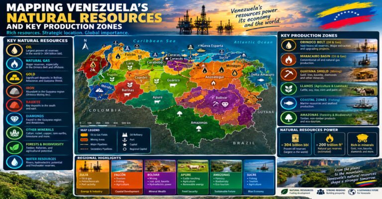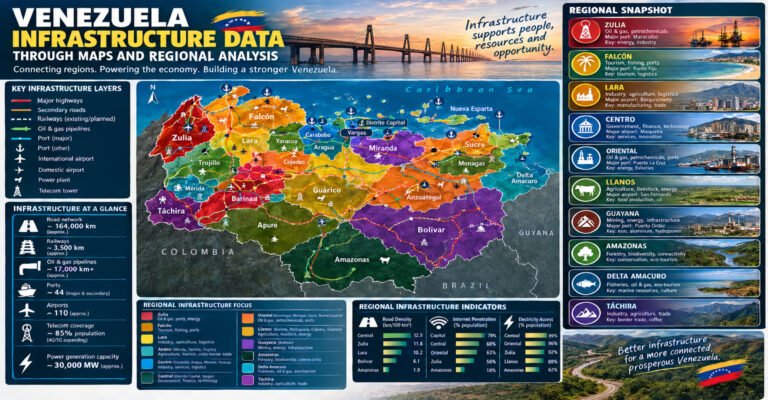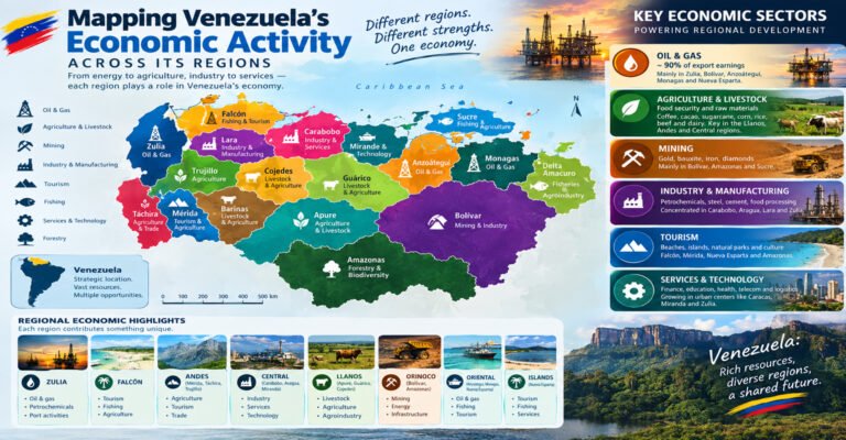
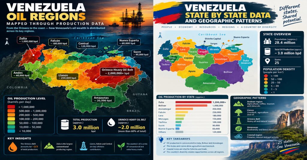
Venezuela is a country of strong geographic contrasts. It has Caribbean beaches in the north, high mountains in the west, wide grasslands across the centre, large forests in the south, and huge river systems across the interior. These landscapes shape where people live, where cities grow, where farms operate, and where natural resources are found.
Looking at Venezuela only as one country can hide many of these differences. The pattern becomes clearer when the country is studied state by state.
This guide presents Venezuela State by State Data in a simple way. It looks at the 23 states and explains their location, capital, population pattern, land area, climate, major cities, economic activities, natural resources, and geographic role.
The goal is not just to list state names. The goal is to explain what makes each state different and how the states fit together.
Venezuela has 23 states, along with the Capital District and federal dependencies. The country covers about 916,445 square kilometers. Its population is concentrated much more heavily in the north and central parts of the country than in the vast southern states.
That creates one of the most important geographic patterns in Venezuela: large areas of land do not always mean large populations.
Amazonas and Bolívar cover enormous areas, but their population density is low. Carabobo, Miranda, Aragua, and the Capital District are much smaller but contain dense urban areas and major economic activity.
This difference is central to understanding Venezuela.
Venezuela State by State Data: Quick Overview
Before looking at each state, it helps to understand the national pattern.
Venezuela’s 23 states stretch from the Caribbean coast to the borders with Colombia, Brazil, and Guyana. The country also includes island territories and federal dependencies.
The main administrative units are:
- 23 states form the main state-level structure of Venezuela.
- The Capital District contains Caracas, the national capital.
- Federal dependencies include numerous islands, cays, and other offshore territories.
- La Guaira is a state on the central Caribbean coast and is closely linked to Caracas.
- Nueva Esparta is an island state centered on Margarita and nearby islands.
The states can also be grouped into broad geographic regions.
Main geographic patterns
Venezuela is often described through several major physical regions:
- The Andes dominate parts of the western and southwestern highlands.
- The Coastal Range runs through much of northern Venezuela.
- The Llanos form broad grassland plains across central Venezuela.
- The Guiana Highlands cover much of the south and southeast.
- The Orinoco River system connects large parts of the interior.
- The Caribbean coast and islands form an important northern zone.
- The Maracaibo Basin creates a distinct western landscape around Lake Maracaibo.
These physical regions do not follow state borders perfectly. A single state can contain more than one type of landscape.
That is why Venezuela State by State Data works best when administrative information is combined with geography.
Venezuela State by State Data and Population Patterns
Population is one of the clearest ways to see how unevenly Venezuela is settled.
The 2011 national census recorded about 27.2 million people. Later estimates differ because Venezuela has experienced major migration and demographic change. For that reason, state-level population figures should always be tied to a specific year or source.
The older census remains useful for comparing the relative size of states because it provides a common reference point.
Some states have large urban populations packed into small areas. Others cover huge territories with relatively few residents.
For example:
- Miranda has a high population concentration around Caracas and surrounding urban areas.
- Carabobo is small in area but has a large population centered around Valencia.
- Aragua also has a strong urban and industrial population pattern.
- Zulia combines a large population with a huge oil-producing territory.
- Amazonas has one of the country’s lowest population densities.
- Bolívar is one of the largest states by area but has a much lower average population density than central states.
This means population density is often more useful than population alone.
A state with one million people can have a very different geographic character depending on whether those people live across 5,000 square kilometers or 75,000 square kilometers.
Venezuela State by State Data: State and Capital Table
The following table gives a simple starting point for all 23 states.
| State | Capital | Approx. area | Broad geographic pattern |
|---|---|---|---|
| Amazonas | Puerto Ayacucho | 180,000 km² | Forests, rivers, Guiana Highlands |
| Anzoátegui | Barcelona | 43,300 km² | Caribbean coast, plains, energy |
| Apure | San Fernando de Apure | 76,500 km² | Llanos grasslands |
| Aragua | Maracay | 7,014 km² | Mountains, valleys, urban industry |
| Barinas | Barinas | 35,200 km² | Llanos and Andean foothills |
| Bolívar | Ciudad Bolívar | 238,000 km² | Guiana Highlands, rivers, minerals |
| Carabobo | Valencia | 4,650 km² | Dense urban and industrial zone |
| Cojedes | San Carlos | 14,800 km² | Llanos and agricultural land |
| Delta Amacuro | Tucupita | 40,200 km² | Orinoco Delta and wetlands |
| Falcón | Coro | 24,800 km² | Dry coast, peninsula, energy |
| Guárico | San Juan de los Morros | 64,986 km² | Llanos plains |
| Lara | Barquisimeto | 19,800 km² | Dry valleys, farming, cities |
| Mérida | Mérida | 11,300 km² | Andes and mountain valleys |
| Miranda | Los Teques | 7,950 km² | Dense urban and coastal mountains |
| Monagas | Maturín | 28,900 km² | Eastern plains and oil |
| Nueva Esparta | La Asunción | about 1,150 km² | Caribbean islands |
| Portuguesa | Guanare | 15,200 km² | Agricultural plains and foothills |
| Sucre | Cumaná | 11,800 km² | Caribbean coast and mountains |
| Táchira | San Cristóbal | 11,100 km² | Andes and border region |
| Trujillo | Trujillo | 7,400 km² | Andean mountains and farming |
| La Guaira | La Guaira | about 1,500 km² | Caribbean coast and port |
| Yaracuy | San Felipe | 7,100 km² | Valleys, farming, mountains |
| Zulia | Maracaibo | 63,100 km² | Lake Maracaibo, oil, agriculture |
Area figures can vary slightly between references because of boundary methods and administrative definitions. They should be treated as geographic reference values rather than survey measurements.
Venezuela State by State Data: Amazonas
Location and geography of Amazonas
Amazonas is in southern Venezuela and borders Colombia and Brazil. It is one of the country’s largest states by area and one of its least densely populated.
The capital is Puerto Ayacucho.
Much of Amazonas is covered by forests, rivers, and rugged terrain. The state forms part of the wider Guiana Shield landscape, one of the oldest geological areas on Earth.
The region has a very different appearance from the crowded urban areas around Caracas.
Large parts of the state are difficult to reach by road. Rivers are important transport routes, and many communities are small and widely separated.
Population pattern in Amazonas
Amazonas has a small population compared with its huge land area.
This creates a very low population density.
The population is concentrated around settlements such as Puerto Ayacucho and river communities, while enormous areas have few permanent residents.
Indigenous communities are an important part of the state’s population and cultural identity.
Economy and resources
Economic activity is closely linked to local communities, public services, small-scale trade, forestry-related activities, fishing, and tourism.
The state’s natural environment is one of its most important assets.
Important geographic features include:
- Large tropical forest areas.
- Major rivers and tributaries.
- Tepui and plateau landscapes.
- Indigenous territories and communities.
- High levels of biological diversity.
Mining has also been an important issue in parts of southern Venezuela. Its environmental effects are a major reason why geographic data needs to be considered alongside economic data.
Why Amazonas matters in Venezuela State by State Data
Amazonas shows why area and population should never be treated as the same thing.
It is geographically enormous but lightly populated.
That makes it an important example of Venezuela’s southern geographic pattern.
Venezuela State by State Data: Anzoátegui
Location and geography of Anzoátegui
Anzoátegui sits in eastern Venezuela along the Caribbean coast.
Its capital is Barcelona.
The state connects coastal areas with inland plains and energy-producing zones. Its geography gives it access to both the sea and the interior.
The state is also closely connected with neighboring Monagas and other eastern energy regions.
Major cities
Barcelona is part of a larger urban area that also includes Puerto La Cruz, Lechería, and nearby communities.
This coastal urban belt is important for trade, services, tourism, and energy-related activity.
The state also contains large rural areas away from the main cities.
Energy and industry
Anzoátegui has long been important to Venezuela’s petroleum industry.
The state contains oil and gas infrastructure and is connected to the wider Eastern Venezuela Basin.
Important activities include:
- Oil production and related services.
- Natural gas activity.
- Port operations.
- Tourism.
- Commerce.
- Agriculture.
- Manufacturing and services.
The state’s position on the Caribbean gives it a useful connection between inland production and coastal transport.
Geographic pattern
Anzoátegui is a good example of a state where geography and industry are closely linked.
Coastal cities, roads, ports, energy facilities, and inland production areas form a connected system.
Venezuela State by State Data: Apure
Location and geography of Apure
Apure lies in southwestern Venezuela along the Colombian border.
Its capital is San Fernando de Apure.
The state is part of the Llanos, a broad system of tropical plains.
The land is relatively flat, and seasonal changes in rainfall can strongly affect rivers, roads, agriculture, and livestock.
Population pattern
Apure has a relatively small population for its large area.
Many people live in towns and settlements linked to agriculture, livestock, trade, and government services.
The state has a much lower population density than Venezuela’s central urban states.
Agriculture and livestock
Agriculture and cattle raising are major parts of the state’s geographic identity.
The plains support:
- Cattle ranching.
- Rice and other crops in suitable areas.
- Fishing.
- Local food production.
- River-based activities.
The Llanos also support important wildlife habitats.
Why Apure matters
Apure demonstrates how Venezuela’s central plains work.
Its importance is not based on dense cities. Instead, it comes from land, water, agriculture, livestock, and connections between rural communities.
Venezuela State by State Data: Aragua
Location and geography of Aragua
Aragua is in north-central Venezuela.
Its capital is Maracay.
The state is relatively small but highly populated compared with many southern and plains states.
Its geography includes mountain ranges, valleys, agricultural areas, urban centers, and access to the Caribbean coast.
Maracay and urban development
Maracay is one of Venezuela’s major cities.
The city developed strongly through manufacturing, commerce, services, and its position near Caracas and other central markets.
Aragua’s location gives it an advantage in road connections between the capital region and western Venezuela.
Economy
Aragua has a mixed economy that includes:
- Manufacturing.
- Food processing.
- Agriculture.
- Commerce.
- Services.
- Tourism.
- Transportation.
The valleys are important for agriculture, while the urban areas contain much of the state’s industry and population.
Geographic pattern
Aragua shows how a small state can have a large economic role.
Its high population density comes from its favorable location, urban networks, transport links, and productive valleys.
Venezuela State by State Data: Barinas
Location and geography
Barinas is located between the Andes and the Llanos.
Its capital is Barinas.
This position gives the state a mixed landscape.
Mountain foothills occur toward the west, while flatter plains extend toward the east.
Agriculture
Barinas has an important agricultural economy.
Activities include:
- Cattle production.
- Crops.
- Rice and other grains.
- Oil-related activity in some areas.
- Food processing.
- Trade.
Its location makes it a bridge between Andean farming zones and the central plains.
Population pattern
Population is concentrated around Barinas and other towns.
Large rural areas remain less densely populated.
This makes Barinas an important example of a transition state between two major geographic systems.
Venezuela State by State Data: Bolívar
Location and geography
Bolívar is one of Venezuela’s largest states.
Its area is roughly 238,000 square kilometers.
The capital is Ciudad Bolívar, while Ciudad Guayana is one of the state’s largest urban and industrial centers.
The state is dominated by the Guiana Shield and major river systems.
The Orinoco and Caroní
The Orinoco River is one of the most important geographic features in Venezuela.
The Caroní River is also extremely important because of its hydropower potential.
The region around Ciudad Guayana became a major industrial center partly because of access to energy, rivers, transportation, and mineral resources.
Mining and minerals
Bolívar is known for major mineral resources.
These include:
- Iron ore.
- Gold.
- Bauxite.
- Other mineral deposits.
Mining has helped shape the state’s economy but has also created environmental and land-use challenges.
Canaima and tourism
Bolívar contains Canaima National Park, a major natural area known for tepuis, waterfalls, forests, and unique landscapes.
Angel Falls is one of the best-known natural features in Venezuela.
Tourism therefore forms another part of the state’s economic potential.
Why Bolívar is important
Bolívar demonstrates the relationship between land, minerals, rivers, energy, industry, and biodiversity.
It is one of the clearest examples of how geographic resources can shape an entire state.
Venezuela State by State Data: Carabobo
Location and geography
Carabobo is one of Venezuela’s smallest states by area.
Its capital is Valencia.
Despite its small size, it has a large population and a strong industrial base.
This makes Carabobo one of the country’s clearest examples of high population density.
Valencia
Valencia is a major urban and industrial center.
The city and surrounding area have strong links to manufacturing, trade, transport, and services.
The state also has access to the Caribbean through Puerto Cabello, an important port.
Economic role
Carabobo’s economy includes:
- Manufacturing.
- Automotive activity.
- Food production.
- Chemicals.
- Commerce.
- Logistics.
- Port-related services.
The combination of a major city, highways, industrial areas, and port access gives the state a strong geographic position.
Geographic lesson
Carabobo shows that a state’s economic importance does not depend on its size.
A small area can become highly productive when transport, industry, population, and markets are close together.
Venezuela State by State Data: Cojedes
Location and geography
Cojedes is in central Venezuela.
Its capital is San Carlos.
Much of the state belongs to the Llanos.
The landscape includes open plains, agricultural land, rivers, and rural settlements.
Economy
Agriculture and livestock are central to the state.
Important activities include:
- Cattle raising.
- Crop production.
- Food processing.
- Trade.
- Services.
Cojedes has a lower population density than the major central urban states.
Geographic pattern
The state is a useful example of Venezuela’s agricultural interior.
Its importance comes from productive land and its position between more densely populated regions.
Venezuela State by State Data: Delta Amacuro
Location and geography
Delta Amacuro is in northeastern Venezuela.
Its capital is Tucupita.
The state contains a large part of the Orinoco Delta, where the river divides into many channels before reaching the Atlantic Ocean.
Water defines much of the state’s geography.
Communities and transport
Many communities are connected by waterways rather than large road networks.
The delta supports fishing, small-scale agriculture, local trade, and river transport.
The Warao people are especially important to the cultural history of the region.
Environmental importance
Wetlands, mangroves, forests, and river channels make Delta Amacuro environmentally important.
Flooding and changing river levels can affect transportation and settlement.
Geographic lesson
Delta Amacuro shows how rivers can shape nearly every part of life.
In this state, geography is not just background. It is part of the transport system, economy, culture, and settlement pattern.
Venezuela State by State Data: Falcón
Location and geography
Falcón is in northwestern Venezuela.
Its capital is Coro.
The state includes dry landscapes, coastal areas, mountains, and the Paraguaná Peninsula.
Energy importance
Falcón is closely linked to Venezuela’s refining system.
The Paraguaná area contains major refining facilities, making the state important to the country’s downstream oil sector.
This is different from simply having oil fields.
Oil production, refining, storage, shipping, and fuel distribution are separate parts of the energy system.
Coro and tourism
Coro has historical importance and is known for its colonial architecture.
The state also has coastal and desert-like landscapes that support tourism.
Geographic pattern
Falcón combines:
- Energy.
- Ports.
- Coastal cities.
- Dry ecosystems.
- Historic sites.
- Tourism.
That combination gives it a distinctive place in Venezuela State by State Data.
Venezuela State by State Data: Guárico
Location and geography
Guárico is one of the large central states.
Its capital is San Juan de los Morros.
Much of the state is part of the Llanos.
Agriculture and livestock
The open plains support cattle raising and agriculture.
Rice, corn, sorghum, and other crops can be important depending on location and water access.
The state also contains oil-producing areas.
Population pattern
Guárico has a relatively low population density compared with central coastal states.
Its cities are separated by large areas of rural land.
Geographic role
Guárico connects several parts of Venezuela.
It sits between the northern urban belt and the southern plains.
Road networks through the state help connect agricultural areas with larger markets.
Venezuela State by State Data: Lara
Location and geography
Lara is in northwestern-central Venezuela.
Its capital is Barquisimeto.
The state contains dry valleys, mountains, agricultural zones, and major urban areas.
Barquisimeto
Barquisimeto is one of Venezuela’s largest cities.
It is an important commercial and transportation center.
Its location makes it a natural connection point between western, central, and agricultural areas.
Agriculture
Lara has a strong agricultural identity.
Depending on local conditions, production includes:
- Vegetables.
- Fruits.
- Sugar-related agriculture.
- Livestock.
- Other crops suited to dry and semi-dry areas.
Geographic pattern
Lara is important because it sits between several geographic zones.
It links the Andes, central Venezuela, and the western states.
Venezuela State by State Data: Mérida
Location and geography
Mérida is an Andean state.
Its capital is Mérida.
The state is known for high mountains, deep valleys, cooler temperatures at elevation, and steep terrain.
Mountain communities
Population tends to follow valleys and accessible slopes.
This creates a very different settlement pattern from the flat Llanos.
Roads can be difficult and expensive to build because of steep terrain and landslide risks.
Agriculture and tourism
Mérida is known for agricultural production in mountain valleys.
Tourism is also important.
Visitors are attracted by:
- Mountain scenery.
- Hiking.
- Historic towns.
- Cooler weather.
- High-altitude landscapes.
Geographic lesson
Mérida shows how elevation changes climate, farming, transport, and settlement.
A short distance on a map can represent a large change in altitude.
Venezuela State by State Data: Miranda
Location and geography
Miranda is in north-central Venezuela.
Its capital is Los Teques.
The state surrounds much of the Caracas metropolitan area and contains a mix of mountains, valleys, cities, and coastal areas.
Population and urbanization
Miranda is one of the most densely populated states.
Large urban areas include communities linked to Caracas and the wider central metropolitan system.
The state’s population pattern is strongly urban.
Economy
Miranda has major activity in:
- Commerce.
- Services.
- Manufacturing.
- Finance-related services.
- Food production.
- Transportation.
- Technology and communications.
The state’s proximity to Caracas is one of its biggest geographic advantages.
Geographic pattern
Miranda shows the opposite pattern from Amazonas.
Instead of a huge land area with few people, Miranda has a relatively small territory with a large urban population.
This contrast is one of the most important themes in Venezuela State by State Data.
Venezuela State by State Data: Monagas
Location and geography
Monagas is in eastern Venezuela.
Its capital is Maturín.
The state contains plains, forests, rivers, and oil-producing areas.
Oil and energy
Monagas is one of Venezuela’s major petroleum states.
It is linked to the Eastern Venezuela Basin and the broader Orinoco petroleum system.
Oil and natural gas have influenced roads, cities, services, and employment patterns.
Maturín
Maturín grew strongly as an energy and service center.
The city serves surrounding oil-producing and agricultural areas.
Agriculture
Agriculture also remains important.
Activities include cattle, crops, and food production.
Geographic pattern
Monagas is a good example of how natural resources can change the settlement pattern of a state.
Energy activity creates demand for roads, services, housing, skilled workers, and industrial support.
Venezuela State by State Data: Nueva Esparta
Location and geography
Nueva Esparta is an island state in the Caribbean.
Its capital is La Asunción.
The state includes Margarita Island, Coche, and Cubagua.
Economy
Tourism is one of the most visible economic activities.
Other activities include:
- Fishing.
- Commerce.
- Hospitality.
- Transportation.
- Small businesses.
- Services.
Population pattern
The population is concentrated around towns, coastal areas, and commercial centers.
Island geography means transportation links are especially important.
Goods and people must move through ports and air connections.
Geographic lesson
Nueva Esparta demonstrates how island geography changes economic planning.
Water is both a resource and a transportation barrier.
Venezuela State by State Data: Portuguesa
Location and geography
Portuguesa is in central-western Venezuela.
Its capital is Guanare.
The state sits between the Llanos and the foothills of the Andes.
Agriculture
Portuguesa is one of Venezuela’s important agricultural areas.
The state supports crops such as rice, corn, sugar-related production, and other farm products.
Agriculture has helped create processing industries and rural employment.
Population pattern
Population is concentrated around agricultural towns and transport corridors.
The state is less densely urbanized than Carabobo or Miranda.
Geographic role
Portuguesa is an important food-producing link between the plains and the mountain foothills.
Venezuela State by State Data: Sucre
Location and geography
Sucre is in northeastern Venezuela.
Its capital is Cumaná.
The state has a long Caribbean coastline, mountains, valleys, and coastal communities.
Fishing and coastal activity
Fishing has traditionally been important.
Other activities include:
- Agriculture.
- Tourism.
- Commerce.
- Port activity.
- Small-scale industries.
Cumaná
Cumaná is one of Venezuela’s oldest established European-founded cities.
Its coastal location has shaped trade, fishing, tourism, and transportation.
Geographic pattern
Sucre is strongly connected to the Caribbean.
Its economy and communities are influenced by the sea as much as by inland geography.
Venezuela State by State Data: Táchira
Location and geography
Táchira is in western Venezuela on the Colombian border.
Its capital is San Cristóbal.
The state is part of the Andes and contains mountain valleys and highland terrain.
Border economy
The location near Colombia gives Táchira a special economic role.
Cross-border movement has historically affected trade, transport, employment, and local commerce.
Agriculture
Mountain and valley areas support agriculture.
Products can include coffee, vegetables, livestock, and other crops suited to the local climate.
Geographic pattern
Táchira is an important example of a border state.
Its geography is shaped by both the Andes and its international boundary.
Venezuela State by State Data: Trujillo
Location and geography
Trujillo is an Andean state in western Venezuela.
Its capital is Trujillo.
The landscape includes mountains, valleys, and agricultural areas.
Agriculture
Farming is important in suitable valleys and highland areas.
Production varies by elevation.
Different crops grow at different heights because temperature and rainfall change across the mountains.
Population pattern
Settlements often follow valleys and transport routes.
This creates a more scattered pattern than in the major coastal cities.
Geographic lesson
Trujillo shows the strong link between altitude and agriculture.
The shape of the land helps determine what can be grown and where communities develop.
Venezuela State by State Data: La Guaira
Location and geography
La Guaira is a narrow coastal state north of Caracas.
It was formerly known as Vargas.
Its capital is La Guaira.
The state sits between the Caribbean Sea and the mountains of the Coastal Range.
Port and airport connections
La Guaira has major transport importance because of its proximity to Caracas.
The area includes important port facilities and is close to the country’s main international airport at Maiquetía.
This creates a strong connection between the capital region and international trade.
Geographic challenge
The steep mountains between Caracas and the coast make transport infrastructure especially important.
Heavy rainfall can also create flood and landslide risks.
Geographic pattern
La Guaira is small in area but strategically important.
Its value comes from location rather than land size.
Venezuela State by State Data: Yaracuy
Location and geography
Yaracuy is in north-central Venezuela.
Its capital is San Felipe.
The state contains valleys and mountain areas.
Agriculture
Agriculture is important.
The state’s landscape supports crops, livestock, and food-related activity.
Population pattern
Population is concentrated in valleys and urban centers.
The state is smaller and less densely urbanized than nearby Carabobo.
Geographic role
Yaracuy connects central Venezuela with western agricultural regions.
Its road network helps move goods between different parts of the country.
Venezuela State by State Data: Zulia
Location and geography
Zulia is in northwestern Venezuela.
Its capital is Maracaibo.
The state is centered around the huge Lake Maracaibo basin.
Zulia is one of the most important states in Venezuelan economic geography.
Lake Maracaibo
Lake Maracaibo is a defining feature of the state.
The lake and surrounding basin have supported fishing, agriculture, transport, cities, and the petroleum industry.
The surrounding landscape ranges from relatively dry areas in the north to wetter zones farther south.
Oil industry
Zulia is historically one of Venezuela’s most important petroleum regions.
Oil development around Lake Maracaibo helped transform cities such as Maracaibo, Cabimas, Lagunillas, and other communities.
The region contains mature oil fields, meaning many fields have been producing for decades.
Agriculture
Zulia also has important agricultural zones.
Activities include:
- Cattle production.
- Dairy farming.
- Crops.
- Fishing.
- Food processing.
Maracaibo
Maracaibo is one of Venezuela’s largest cities.
Its position near the lake and oil-producing areas helped make it an important commercial and energy center.
Geographic pattern
Zulia shows how one geographic basin can support several economic systems at the same time.
Oil, agriculture, water, cities, ports, and roads all interact.
Venezuela State by State Data and the Capital District
Caracas
Caracas is Venezuela’s national capital.
It is not one of the 23 states. It is located in the Capital District.
The city sits in a mountain valley close to the Caribbean coast.
Population concentration
Caracas and the surrounding central region form one of Venezuela’s strongest population concentrations.
The capital attracts government institutions, businesses, universities, financial services, media, and other organizations.
Why the Capital District is different
The Capital District is geographically small but nationally important.
This is another example of why land area alone cannot explain geographic importance.
A small territory can have an enormous role when it contains the country’s political and administrative center.
Venezuela State by State Data and the Federal Dependencies
The federal dependencies are separate from the 23 states.
They include numerous islands, cays, and small territories.
The best-known island groups include areas such as Los Roques and other Caribbean archipelagos.
These territories have different economic and geographic characteristics from mainland states.
Tourism, fishing, marine ecosystems, and coastal resources are important.
The federal dependencies also show why a complete map of Venezuela must include both mainland and offshore territories.
Venezuela State by State Data: Where People Live
One of the strongest patterns in Venezuela is the uneven distribution of population.
People are not spread evenly across the country’s land area.
The highest population concentrations are generally found in:
- Caracas and nearby areas.
- The central coastal corridor.
- Valencia and Carabobo.
- Maracay and Aragua.
- Barquisimeto and Lara.
- Maracaibo and Zulia.
- Major cities in the east and west.
Large areas of the south and interior have much lower population density.
Why is population concentrated in the north?
Several factors help explain this pattern.
Northern Venezuela has:
- More large cities.
- Better-established transport networks.
- Major ports.
- Industrial centers.
- Older agricultural zones.
- Government institutions.
- More developed commercial networks.
The southern states contain huge forests, rivers, protected areas, and mineral zones.
Those areas are important, but they are not naturally suited to dense urban settlement across large territories.
Venezuela State by State Data: Urban and Rural Patterns
Venezuela is highly urbanized.
Most people live in cities or urban areas.
This creates a strong difference between the population map and the land-use map.
A state can have large agricultural or forest areas while most of its people live in one or two major cities.
For example, a state may appear mostly green or rural on a land-cover map but still have a heavily urban population.
This is why geographic analysis should compare several maps instead of relying on only one.
Useful maps to compare
A strong Venezuela data project can compare:
- Administrative boundaries.
- Population density.
- Major cities.
- Roads.
- Rivers.
- Elevation.
- Agricultural land.
- Oil fields.
- Mining areas.
- Protected areas.
- Ports.
- Airports.
- Industrial zones.
Together, these maps reveal much more than a simple state map.
Venezuela State by State Data and Climate
Climate varies strongly across Venezuela.
The country is mostly tropical, but elevation creates major differences.
Lowland tropical areas
Many lowland areas are hot throughout the year.
This includes large parts of the Llanos, Amazon region, and coastal lowlands.
Mountain climates
Higher elevations in Mérida, Táchira, Trujillo, and other mountain areas can be much cooler.
This creates different farming systems.
Dry regions
Parts of Falcón, Lara, and northern coastal areas are relatively dry.
These areas have different vegetation and agricultural patterns from the wetter south.
Wet regions
Southern Venezuela and parts of the Orinoco system receive much more rainfall.
This supports forests, rivers, wetlands, and dense natural vegetation.
Venezuela State by State Data and Elevation
Elevation is one of the most useful variables for understanding Venezuelan geography.
At sea level, temperatures are generally high.
As elevation rises, temperatures usually fall.
This helps explain why:
- Mountain cities can have cooler climates.
- Certain crops grow better at higher elevations.
- Roads can become more difficult to build.
- Population settlements follow valleys.
- Landslides can become a major risk.
The Andes therefore create a very different geographic pattern from the flat Llanos.
Venezuela State by State Data and Rivers
Rivers are central to Venezuela’s geography.
The Orinoco River is the country’s most important river system.
Its basin covers a huge portion of Venezuela.
Other important river systems include the Caroní and Apure.
Rivers affect:
- Agriculture.
- Hydropower.
- Transport.
- Fishing.
- Flood risk.
- Wetlands.
- Wildlife.
- Settlement.
The Orinoco pattern
The Orinoco flows across the interior before reaching the Atlantic through its large delta.
This connects many states through one broad drainage system.
That makes river geography especially useful when studying state boundaries.
Venezuela State by State Data and Natural Resources
Natural resources are not spread evenly across Venezuela.
Different states have different resource profiles.
Petroleum
Oil is especially important in:
- Zulia.
- Anzoátegui.
- Monagas.
- Guárico.
- Other areas connected to Venezuela’s major petroleum basins.
Natural gas
Gas resources are found in both inland and offshore areas.
Eastern Venezuela and offshore regions are particularly important to the country’s gas geography.
Iron ore
Iron ore is strongly associated with Bolívar.
Gold
Gold mining occurs in southern Venezuela, especially in areas of Bolívar and nearby territories.
Bauxite
Bauxite resources are also associated with the Guiana region.
Hydropower
The Caroní River system in Bolívar is central to Venezuela’s hydropower infrastructure.
Agriculture
Agriculture is spread across many states, but major agricultural zones include:
- Portuguesa.
- Barinas.
- Guárico.
- Cojedes.
- Lara.
- Yaracuy.
- Zulia.
- Mérida.
- Táchira.
This distribution shows that Venezuela’s economy is more than oil.
Venezuela State by State Data and Agriculture
Agriculture follows climate, soil, water, and transportation.
This creates different farming patterns across the country.
Llanos agriculture
The Llanos are especially suited to livestock and certain large-scale crops.
States such as Apure, Guárico, Cojedes, Barinas, and Portuguesa have important agricultural landscapes.
Mountain agriculture
The Andes support crops that benefit from cooler temperatures and elevation.
Mérida, Táchira, and Trujillo are important examples.
Dry-zone agriculture
Lara and parts of Falcón have drier conditions.
Farming therefore depends more strongly on irrigation and local water conditions in some areas.
Venezuela State by State Data and Industry
Industrial activity is concentrated more heavily in central and coastal areas.
Carabobo is one of the clearest industrial centers.
Aragua also has a strong manufacturing base.
Miranda benefits from its connection with Caracas.
Bolívar has a different industrial pattern based strongly on minerals, metals, and energy.
Zulia and the eastern states have large energy-related industries.
This creates several different industrial corridors rather than one national industrial zone.
Venezuela State by State Data and Transportation
Transportation helps explain why certain cities grew faster than others.
Major roads connect:
- Caracas with central states.
- Valencia with western and central regions.
- Barquisimeto with the west.
- Maracaibo with Zulia.
- Eastern cities with oil-producing areas.
- Agricultural states with major markets.
Ports also play a major role.
Important coastal transport centers include areas around:
- La Guaira.
- Puerto Cabello.
- Puerto La Cruz.
- Maracaibo.
- Other Caribbean ports.
Airports connect major cities and remote regions.
In the south, rivers remain important because road access can be limited.
Venezuela State by State Data and Major Cities
A state-by-state map becomes easier to understand when the main cities are included.
Some of the country’s major urban centers are:
- Caracas, the national capital.
- Maracaibo, the major city of Zulia.
- Valencia, the main urban center of Carabobo.
- Barquisimeto, the main city of Lara.
- Maracay, the capital of Aragua.
- Barcelona, the capital of Anzoátegui.
- Ciudad Guayana, a major industrial center in Bolívar.
- Maturín, a major city in Monagas.
- San Cristóbal, the main city of Táchira.
- Ciudad Bolívar, the capital of Bolívar.
- Cumaná, the capital of Sucre.
These cities form a network rather than isolated centers.
Venezuela State by State Data: North Versus South
A simple north-south comparison helps explain Venezuela.
Northern Venezuela
Northern Venezuela generally has:
- More cities.
- More roads.
- More ports.
- Higher population density.
- More industry.
- More established commercial networks.
- More concentrated services.
Southern Venezuela
Southern Venezuela generally has:
- Larger forests.
- Lower population density.
- Major rivers.
- Mineral resources.
- Indigenous communities.
- Large protected areas.
- More difficult transportation.
This does not mean the south is unimportant.
It means its importance comes from a different combination of geography and resources.
Venezuela State by State Data: East Versus West
The east and west also have different patterns.
Western Venezuela
The west includes:
- Zulia.
- Falcón.
- Lara.
- Táchira.
- Mérida.
- Trujillo.
- Parts of Barinas and Portuguesa.
This area contains the Maracaibo Basin, Andes, dry western landscapes, agricultural valleys, and major border connections.
Eastern Venezuela
The east includes:
- Anzoátegui.
- Monagas.
- Sucre.
- Delta Amacuro.
- Eastern parts of Guárico and Bolívar.
The region is strongly linked to the Eastern Venezuela Basin, the Caribbean coast, the Orinoco system, and energy production.
Venezuela State by State Data and Oil Geography
Oil geography is an important part of Venezuela’s state-level pattern.
The largest petroleum systems do not fit neatly inside state borders.
The major areas include the Maracaibo Basin in the west and the Eastern Venezuela Basin, including the Orinoco petroleum region.
Zulia and Lake Maracaibo
Zulia is the historic center of Venezuela’s oil industry.
Oil development around Lake Maracaibo created cities, roads, ports, pipelines, service companies, and industrial facilities.
Monagas and Anzoátegui
Eastern states became major energy centers through production, processing, transportation, and export infrastructure.
Orinoco region
The Orinoco Oil Belt extends across a very large area of eastern Venezuela.
Its crude is generally very heavy.
This affects how oil must be produced, transported, upgraded, refined, and marketed.
Venezuela State by State Data and Mining Geography
Mining is strongly concentrated in southern Venezuela.
Bolívar is especially important.
The Guiana Shield contains major mineral deposits.
However, mining geography must be studied alongside environmental geography.
Mining can affect:
- Rivers.
- Forests.
- Wildlife.
- Indigenous territories.
- Roads.
- Local economies.
A useful geographic map should therefore show both mineral areas and environmentally sensitive zones.
Venezuela State by State Data and Environmental Patterns
Environmental conditions vary from state to state.
Different regions face different risks.
Flooding
Flood risk is important in:
- Llanos areas.
- River valleys.
- The Orinoco Delta.
- Some coastal zones.
Landslides
Mountain states such as Mérida, Táchira, Trujillo, Miranda, and La Guaira can face landslide risks.
Drought
Drier areas in Falcón and Lara can experience water stress.
Coastal risks
Coastal states can face erosion, storms, flooding, and pressure from urban development.
Forest pressure
Southern states can face pressure from mining, roads, fires, and other land-use changes.
These patterns show why geographic data is useful for planning.
Venezuela State by State Data and Infrastructure
Infrastructure is not equally distributed.
Central states generally have denser road and utility networks.
Remote southern areas face greater transport challenges.
Infrastructure patterns are influenced by:
- Population.
- Terrain.
- Industry.
- Economic history.
- Distance from major cities.
- River systems.
A road in the mountains has different costs and risks from a road across a flat plain.
A road through the Amazon forest faces a different set of environmental and logistical issues.
Venezuela State by State Data: How to Read Population Density
Population density is calculated by dividing population by land area.
The basic formula is:
Population density = population ÷ land area
This simple measure helps compare states.
For example, a small state with a large population can have very high density.
A large state with a small population can have very low density.
This explains why Carabobo and Miranda look very different from Amazonas and Bolívar.
But density has a limitation.
It gives an average.
A state can have a high average density while still containing mountains, forests, farms, or protected areas.
For deeper analysis, population density should be mapped at the municipal or neighborhood level when data is available.
Venezuela State by State Data: Why Census Years Matter
Population numbers are not fixed.
They change because of:
- Births.
- Deaths.
- Migration.
- Internal movement.
- Urban growth.
- Economic conditions.
Venezuela has experienced major migration in recent years.
That means older census data should not be presented as if it were a current population count.
A good article or map should always label the year of the population estimate.
This is an important part of trustworthy Venezuela State by State Data.
Venezuela State by State Data and Migration
Migration has changed the demographic picture.
People have moved both internationally and within Venezuela.
Some families have moved toward larger cities because of jobs, education, health care, and other services.
Others have left the country.
This can change the population balance between states.
For this reason, current geographic analysis should avoid pretending that one old census tells the complete story.
Venezuela State by State Data and Economic Diversity
It is easy to describe Venezuela as an oil country.
Oil is clearly important, but that description is incomplete.
Different states depend on different economic systems.
For example:
- Carabobo has strong industrial and commercial activity.
- Portuguesa has major agricultural activity.
- Bolívar has minerals, energy, industry, and tourism.
- Zulia combines oil, agriculture, cities, and commerce.
- Nueva Esparta has tourism and island commerce.
- Mérida has agriculture and tourism.
- Sucre has fishing, agriculture, tourism, and coastal activity.
- Miranda has services, commerce, manufacturing, and its connection with Caracas.
This state-level view gives a fuller picture of the national economy.
Venezuela State by State Data: A Regional Comparison
Central region
The central region has some of the country’s highest population densities.
Important states include:
- Aragua.
- Carabobo.
- Miranda.
- Cojedes.
- Parts of Guárico.
- La Guaira.
The region has strong urban, industrial, commercial, and transportation networks.
Western region
The west contains:
- Zulia.
- Falcón.
- Lara.
- Yaracuy.
- Táchira.
- Mérida.
- Trujillo.
Its geography includes mountains, dry zones, Lake Maracaibo, farming valleys, and the Colombian border.
Eastern region
The east contains:
- Anzoátegui.
- Monagas.
- Sucre.
- Delta Amacuro.
The region is strongly connected to oil, gas, ports, coastal activity, and the Orinoco system.
Llanos
The plains include:
- Apure.
- Barinas.
- Cojedes.
- Guárico.
- Portuguesa.
The main patterns are agriculture, cattle, rivers, and wide open landscapes.
Guiana region
The southern area includes:
- Amazonas.
- Bolívar.
- Delta Amacuro.
It contains forests, rivers, mineral resources, Indigenous communities, and major protected areas.
Venezuela State by State Data and Regional Connectivity
States should not be studied as isolated boxes.
Economic activity often crosses state borders.
An oil field can be in one state while its refinery or export port is in another.
A farm can produce food in one state while the main market is hundreds of kilometers away.
A mountain community can depend on a city in a neighboring state for hospitals or universities.
A mining project can depend on roads, power, and ports outside the mining area.
This is why geographic patterns are often more important than state boundaries.
Venezuela State by State Data and Administrative Boundaries
State boundaries are political and administrative lines.
Physical geography does not always follow them.
A river may cross several states.
A mountain range may cross multiple administrative areas.
An agricultural region may cover parts of several states.
An oil basin can stretch across several state borders.
Therefore, a good map should show both:
- Administrative boundaries.
- Physical and economic systems.
When these two layers are combined, the geographic picture becomes much clearer.
Venezuela State by State Data: Building a Useful Map
A strong Venezuela map can contain several layers.
Layer 1: State boundaries
Start with all 23 states.
Add the Capital District and federal dependencies separately.
Layer 2: State capitals
Add each state capital.
This helps users connect the political map with the physical map.
Layer 3: Population
Use population data from a clearly labeled year.
Color or size symbols can show where people are concentrated.
Layer 4: Population density
Density often reveals patterns that total population hides.
Layer 5: Cities
Add major urban centers.
Layer 6: Roads
Major highways help explain trade and settlement.
Layer 7: Rivers
Add the Orinoco, Apure, Caroní, and other major rivers.
Layer 8: Resources
Add oil, gas, minerals, agriculture, and hydropower areas.
Layer 9: Environment
Add national parks, forests, wetlands, and protected areas.
This creates a geographic information system rather than a simple political map.
Venezuela State by State Data and GIS
GIS means Geographic Information System.
It is a way to connect information to places on a map.
For Venezuela, GIS can combine:
- Population.
- Roads.
- Rivers.
- Oil fields.
- Mines.
- Cities.
- Agriculture.
- Climate.
- Elevation.
- Infrastructure.
A GIS map can answer questions such as:
Where are the most populated states?
Which states have major oil infrastructure?
Which cities are close to ports?
Where do agricultural areas overlap with major roads?
Which communities are far from major transport routes?
These questions are much easier to answer when data is mapped.
Venezuela State by State Data and Economic Corridors
An economic corridor is an area where transport, cities, businesses, and production are connected.
Venezuela has several important corridors.
The central corridor around Caracas, Aragua, and Carabobo is one of the strongest.
The western corridor links Lara, Zulia, and other western states.
Eastern corridors connect coastal cities with oil and gas production.
Southern corridors connect mining and industrial areas with rivers, roads, and cities.
These corridors help explain why some places grow faster than others.
Venezuela State by State Data and Ports
Ports are critical to a country with a long Caribbean coastline.
They connect domestic production with international trade.
Important port areas include:
- La Guaira.
- Puerto Cabello.
- Maracaibo.
- Puerto La Cruz.
- Other eastern and western coastal facilities.
The geographic importance of a port depends on more than the port itself.
A useful port map should also show:
- Roads.
- Rail where available.
- Industrial areas.
- Storage facilities.
- Nearby cities.
- Production zones.
This creates a fuller picture of logistics.
Venezuela State by State Data and Airports
Airports become especially important where roads are difficult.
Major cities have larger airports and more connections.
Remote regions often depend more on smaller airports or river transport.
The geographic role of aviation is therefore different in Caracas and Amazonas.
In a dense urban state, an airport supports business and international travel.
In a remote region, an airport can be a vital link for people, supplies, health services, and tourism.
Venezuela State by State Data and Tourism
Tourism is closely tied to geography.
Different states offer different tourism experiences.
Mérida
Mountain tourism is a major attraction.
Bolívar
Canaima and the tepuis are major natural attractions.
Nueva Esparta
Beaches, islands, and coastal tourism are important.
Falcón
Coastal landscapes and historic sites attract visitors.
Sucre
Caribbean beaches and natural areas are important.
Amazonas
Forest, river, wildlife, and Indigenous cultural tourism have potential.
Zulia
Lake Maracaibo and regional culture contribute to tourism.
This shows that Venezuela’s tourism map is highly diverse.
Venezuela State by State Data and Cultural Geography
Geography also shapes culture.
Different states have developed distinct local traditions, foods, music, festivals, and ways of life.
Coastal communities have strong links to fishing and the sea.
Andean communities have traditions shaped by mountains and farming.
Llanos culture is closely linked to cattle ranching, horses, plains, and rural life.
Southern communities have strong Indigenous traditions connected to forests and rivers.
Urban areas such as Caracas, Valencia, Maracaibo, and Barquisimeto have more mixed and diverse cultural influences.
Venezuela State by State Data and Indigenous Communities
Indigenous peoples are an important part of Venezuela’s geographic and cultural story.
Several Indigenous groups live in different parts of the country.
The strongest geographic concentrations are associated with southern and eastern areas, although Indigenous communities are also found elsewhere.
Important considerations include:
- Traditional territories.
- Language.
- Forest use.
- River systems.
- Local economies.
- Cultural heritage.
- Land rights.
Any state-level analysis should avoid treating these communities as simply a statistic.
Geography and culture are closely connected.
Venezuela State by State Data and Water Resources
Water availability differs across Venezuela.
Some regions have large rivers and heavy rainfall.
Others are drier and depend more heavily on reservoirs, groundwater, or managed water systems.
Water matters for:
- Drinking supplies.
- Agriculture.
- Industry.
- Hydropower.
- Fisheries.
- Ecosystems.
- Cities.
The Caroní River is especially important for energy.
The Orinoco system is important for transport and ecosystems.
Lake Maracaibo is important to Zulia’s environment and economy.
Venezuela State by State Data and Hydropower
Bolívar is central to Venezuela’s hydropower system because of the Caroní River.
Large hydropower projects in the region have supplied electricity to cities and industries.
This helped support the development of Ciudad Guayana and other industrial areas.
The geographic lesson is important:
Energy infrastructure can influence where industry develops.
Power generation, mineral resources, transport, and cities can reinforce one another.
Venezuela State by State Data and Industrial Geography
Industrial development tends to cluster around several conditions.
These include:
- Electricity.
- Roads.
- Ports.
- Workers.
- Markets.
- Raw materials.
- Government infrastructure.
- Existing industrial networks.
That is why industrial activity is concentrated in places such as Carabobo, Aragua, Miranda, Bolívar, and parts of Zulia and Anzoátegui.
A state without one of these advantages may have a harder time attracting large industrial facilities.
Venezuela State by State Data and Rural Geography
Rural Venezuela is not one single system.
Rural life differs between:
- Andes.
- Llanos.
- Coastal zones.
- Dry western regions.
- Southern forests.
- River deltas.
In the Andes, farms often occupy valleys and slopes.
In the Llanos, large ranches and open plains are common.
In southern river regions, communities may depend more heavily on fishing and river transport.
In coastal areas, fishing and tourism can shape local economies.
Venezuela State by State Data and Food Production
Food production is spread across several states.
Portuguesa, Barinas, Guárico, Cojedes, Lara, Zulia, Mérida, Táchira, and Yaracuy all have important agricultural areas.
The crops differ because of climate and elevation.
Flat plains can support large fields and mechanized agriculture.
Mountain valleys can support crops that need cooler conditions.
Dry areas may require irrigation.
This makes agricultural geography one of the best examples of how natural conditions influence economic activity.
Venezuela State by State Data: Why State Averages Can Mislead
A state average can hide major differences inside the state.
Take a large state such as Bolívar.
It includes industrial cities, mining zones, forests, rivers, Indigenous communities, and protected areas.
A single population density number cannot describe all of those places.
The same is true for Zulia.
A state-level average combines large urban areas around Maracaibo with rural communities, agricultural areas, oil fields, and wetlands.
This is why detailed geographic research should move from state level to municipal level when possible.
Venezuela State by State Data and Municipal Analysis
Municipal data provides a closer view.
At the municipal level, researchers can study:
- Population.
- Housing.
- Roads.
- Schools.
- Health services.
- Economic activity.
- Agriculture.
- Natural resources.
- Urban growth.
Municipal boundaries are therefore useful for local planning.
But they should still be compared with physical geography.
A municipality can cross a river basin, mountain zone, or agricultural region.
Venezuela State by State Data: Important Data Limits
Reliable geographic analysis requires care.
Different datasets may use different:
- Years.
- Boundaries.
- Population definitions.
- Area calculations.
- Administrative names.
- Projection systems.
A map may therefore look different from another map even when both are reasonable.
Good data practices
Use these basic rules:
- Always label the year.
- Identify whether numbers are estimates or census results.
- Keep administrative boundaries consistent.
- Do not mix old and new population figures without explanation.
- Separate states from the Capital District.
- Treat federal dependencies separately.
- Avoid presenting estimates as exact counts.
These simple steps make geographic content much more trustworthy.
Venezuela State by State Data: 2011 Census as a Reference Point
The 2011 census is useful because it provides a common historical snapshot across all federal entities.
It recorded about 27.2 million people nationally.
The data showed large differences between states.
Zulia had one of the largest populations.
Miranda was also among the most populous.
Carabobo had a large population despite its small land area.
Amazonas had a very small population compared with its huge territory.
These differences remain useful for understanding the long-term settlement pattern, even though current population conditions have changed.
Venezuela State by State Data and Recent Population Change
Recent population estimates should be treated carefully.
Venezuela’s population has been affected by large-scale migration.
That makes direct comparisons between an old census and a recent estimate difficult.
For example, a state may have gained people through urban growth while also losing people through international migration.
Another state may have changed more slowly.
The result is a moving geographic picture.
A current map should therefore use the newest reliable subnational data available and clearly identify its source year.
Venezuela State by State Data and Internal Migration
People also move inside Venezuela.
Movement often follows:
- Employment.
- Education.
- Health care.
- Family networks.
- Housing.
- Transportation.
- Economic opportunity.
Large cities can attract people from rural areas.
Oil-producing areas can attract workers during periods of high activity.
Agricultural regions can experience seasonal movement.
This creates changing population patterns that are not always visible in a state-level map.
Venezuela State by State Data and the Role of Caracas
Caracas has an outsized role in national geography.
The city is the political capital and a major center for business, services, communications, education, and culture.
Its influence extends beyond the Capital District into Miranda and La Guaira.
This creates a metropolitan system rather than a single-city system.
People may live in one administrative area and work or study in another.
This is an important reason why state boundaries do not always match real economic geography.
Venezuela State by State Data and Maracaibo
Maracaibo provides another example of a powerful regional city.
It is closely connected to Lake Maracaibo and Zulia’s petroleum and agricultural systems.
Its regional influence extends across western Venezuela.
The city’s location also gives it links to Colombia and the wider Caribbean.
This makes Maracaibo important for understanding western Venezuelan geography.
Venezuela State by State Data and Valencia
Valencia is central to the industrial geography of Venezuela.
The city benefits from its location in Carabobo.
It has strong links to manufacturing, roads, nearby markets, and Puerto Cabello.
This makes the Valencia area one of the clearest examples of how urban geography and industrial geography overlap.
Venezuela State by State Data and Barquisimeto
Barquisimeto is a major western urban center.
Its position in Lara gives it connections to agricultural areas and several other states.
It functions as a commercial and transport hub.
Its location helps connect western Venezuela with central areas.
Venezuela State by State Data and Ciudad Guayana
Ciudad Guayana is one of the most distinctive cities in Venezuela.
Its growth is strongly linked to the region’s mineral resources, hydropower, and industrial development.
The city sits near the confluence of important river systems and became a major center for heavy industry.
Its history shows how resource geography can shape urban development.
Venezuela State by State Data and the Orinoco Basin
The Orinoco Basin is one of the main geographic systems of Venezuela.
It influences:
- Water.
- Agriculture.
- Wildlife.
- Transport.
- Energy.
- Industry.
- Flood patterns.
Several states are connected to the basin even when they have very different landscapes.
The Llanos, Guiana region, and delta all interact with the Orinoco system.
Venezuela State by State Data and the Llanos
The Llanos are among the most important physical regions in Venezuela.
They stretch across broad plains.
The landscape supports cattle ranching and agriculture.
However, the Llanos are also shaped by seasonal flooding.
During wet periods, rivers can expand across low-lying areas.
During dry periods, water becomes more limited.
This seasonal cycle influences farming, transport, and rural life.
Venezuela State by State Data and the Andes
The Venezuelan Andes occupy the western part of the country.
They include Mérida, Táchira, and Trujillo and influence parts of nearby states.
The mountains affect:
- Climate.
- Farming.
- Roads.
- Settlement.
- Tourism.
- Water.
The Andes also create natural barriers.
Moving people and goods across mountains can require tunnels, bridges, winding roads, and careful engineering.
Venezuela State by State Data and the Guiana Highlands
The Guiana Highlands dominate much of southern Venezuela.
The region contains very old rock formations and dramatic table-top mountains called tepuis.
The landscape is important for:
- Biodiversity.
- Tourism.
- Rivers.
- Hydropower.
- Minerals.
- Indigenous communities.
Bolívar and Amazonas are especially important to this geographic system.
Venezuela State by State Data: What the Map Really Shows
A state map is more than a collection of borders.
It can reveal relationships.
When population, resources, cities, roads, and physical geography are placed together, several patterns become visible.
Pattern one: population follows infrastructure
Large populations often appear near roads, ports, industry, and established cities.
Pattern two: resources influence cities
Oil, minerals, energy, and agriculture can create strong economic centers.
Pattern three: mountains shape settlement
People often concentrate in valleys and accessible areas.
Pattern four: rivers connect regions
River systems can support agriculture, energy, transport, and ecosystems.
Pattern five: southern Venezuela is large but lightly populated
The huge southern states contain extensive forests and resource areas but have relatively low population density.
Venezuela State by State Data: Key Geographic Facts
The most important facts can be summarized simply.
- Venezuela has 23 states.
- Caracas is in the Capital District, not a state.
- Venezuela also has federal dependencies.
- Bolívar is one of the country’s largest states by area.
- Amazonas also covers a very large territory.
- Carabobo is small but densely populated.
- Miranda has a large population and strong links to Caracas.
- Zulia is a major western oil and agricultural state.
- Anzoátegui and Monagas are important eastern energy states.
- Bolívar is central to mining, hydropower, and southern industry.
- Portuguesa and nearby states are important agricultural areas.
- Mérida, Táchira, and Trujillo are strongly shaped by the Andes.
- Nueva Esparta is Venezuela’s main island state.
- Delta Amacuro is dominated by the Orinoco Delta.
- La Guaira is closely linked to Caracas through transport and trade.
Venezuela State by State Data: Frequently Asked Questions
How many states does Venezuela have?
Venezuela has 23 states. It also has the Capital District and federal dependencies.
What is the capital of Venezuela?
Caracas is the national capital. It is located in the Capital District.
What is the largest state in Venezuela?
Bolívar is generally listed as the largest state by area among the 23 states, with roughly 238,000 square kilometers. Amazonas is also very large, covering about 180,000 square kilometers.
Which Venezuelan state has the largest population?
The answer depends on the year and dataset used. Miranda and Zulia have historically been among the most populous states, while Caracas and surrounding metropolitan areas create a major population concentration outside the state ranking itself.
Which Venezuelan state is most densely populated?
Carabobo and other central states have very high population densities because large numbers of people live in relatively small territories.
Which Venezuelan state has the lowest population density?
Amazonas has one of the lowest population densities because it covers a huge area with a relatively small population.
Which state contains Lake Maracaibo?
Lake Maracaibo is mainly associated with Zulia and the wider Maracaibo Basin.
Which states are important for oil?
Zulia, Anzoátegui, Monagas, and parts of Guárico are among the important oil-producing areas. Venezuela’s major petroleum basins extend beyond simple state boundaries.
Which state is known for mining?
Bolívar is particularly important for iron ore, gold, bauxite, and other mineral resources.
Which state contains Canaima National Park?
Canaima National Park is in Bolívar State.
Which state is known for the Andes?
Mérida, Táchira, and Trujillo are major Andean states.
Which states are part of the Llanos?
Apure, Barinas, Cojedes, Guárico, and Portuguesa are strongly associated with the Llanos, although the physical region extends beyond strict state borders.
Which state is an island state?
Nueva Esparta is Venezuela’s principal island state and includes Margarita, Coche, and Cubagua.
What is Venezuela’s most important river?
The Orinoco is Venezuela’s dominant river system and one of the major rivers of South America.
Why is Bolívar important?
Bolívar combines mineral resources, hydropower, major rivers, industrial cities, forests, tourism, and large protected areas.
Why is Zulia important?
Zulia is important because of Lake Maracaibo, petroleum, agriculture, major cities, and its position in western Venezuela.
Why is Carabobo important?
Carabobo is a major industrial and urban center. Valencia and the port area around Puerto Cabello give the state an important economic position.
People Also Ask About Venezuela State by State Data
The following questions match common search intent around Venezuela’s states, geography, population, and maps.
What are the 23 states of Venezuela?
The 23 states are Amazonas, Anzoátegui, Apure, Aragua, Barinas, Bolívar, Carabobo, Cojedes, Delta Amacuro, Falcón, Guárico, Lara, Mérida, Miranda, Monagas, Nueva Esparta, Portuguesa, Sucre, Táchira, Trujillo, La Guaira, Yaracuy, and Zulia.
What are the geographic regions of Venezuela?
Venezuela can be understood through the Andes, Coastal Range, Llanos, Guiana Highlands, Maracaibo Basin, Orinoco system, Caribbean coast, and island areas.
Which Venezuelan states are richest in natural resources?
Resource concentration varies by resource. Zulia and eastern states are important for petroleum, Bolívar is important for minerals and hydropower, and several central and western states are important for agriculture.
Which Venezuelan state is the largest by area?
Bolívar is the largest of the 23 states by area.
Which Venezuelan state is the smallest?
La Guaira is among the smallest states by area.
Where do most Venezuelans live?
Most people live in the northern and central parts of the country, especially around large metropolitan and industrial areas.
Why is southern Venezuela so sparsely populated?
Large parts of the south contain forests, rivers, protected areas, difficult terrain, and remote communities. These conditions make dense urban settlement less common.
What is Venezuela famous for geographically?
Venezuela is known for the Orinoco River, Angel Falls, the tepuis, the Andes, Lake Maracaibo, the Llanos, Caribbean islands, and major petroleum resources.
Which Venezuelan states border Colombia?
Zulia, Táchira, Apure, and Amazonas share land borders with Colombia.
Which Venezuelan states border Brazil?
Amazonas and Bolívar share land borders with Brazil.
Which Venezuelan state borders Guyana?
Bolívar is associated with the eastern land boundary with Guyana, within the context of the long-running territorial dispute over the Essequibo region.
People Also Search For: Venezuela State by State Data
Readers searching for Venezuela State by State Data may also look for related topics such as:
- Venezuela states and capitals.
- Venezuela states map.
- Venezuela population by state.
- Venezuela population density by state.
- Venezuela geographic regions.
- Venezuela administrative divisions.
- Venezuela state capitals.
- Venezuela area by state.
- Venezuela largest states.
- Venezuela smallest states.
- Venezuela largest cities.
- Venezuela geography map.
- Venezuela natural resources by state.
- Venezuela oil states.
- Venezuela agricultural regions.
- Venezuela mining regions.
- Venezuela rivers map.
- Venezuela climate by region.
- Venezuela municipalities map.
- Venezuela political map.
- Venezuela physical map.
- Venezuela population map.
- Venezuela economic regions.
- Venezuela states near Colombia.
- Venezuela states near Brazil.
- Venezuela Caribbean islands.
- Venezuela Orinoco region.
- Venezuela Andes states.
- Venezuela Llanos states.
- Venezuela Guiana region.
- Venezuela Lake Maracaibo region.
These related searches show that users often want more than a simple list of states.
They want to understand how geography affects population, resources, cities, and economic activity.
NLP Keywords for Venezuela State by State Data
For semantic SEO, the article can naturally cover related terms such as:
- Venezuela states
- Venezuela state map
- Venezuela geographic regions
- Venezuela population by state
- Venezuela states and capitals
- Venezuela administrative divisions
- Venezuela geography
- Venezuelan states
- Venezuela population density
- Venezuela area by state
- Venezuela regional data
- Venezuela geographic patterns
- Venezuela natural resources
- Venezuela major cities
- Venezuela climate
- Venezuela rivers
- Venezuela mountains
- Venezuela plains
- Venezuela oil regions
- Venezuela mining regions
- Venezuela agricultural regions
- Venezuela economic geography
- Venezuela regional economy
- Venezuela GIS data
- Venezuela demographic data
- Venezuela state population
- Venezuela state capitals
- Venezuela physical geography
- Venezuela political geography
- Venezuela urban population
- Venezuela rural population
- Venezuela infrastructure
- Venezuela transportation
- Venezuela ports
- Venezuela airports
- Venezuela Orinoco Basin
- Venezuela Andes
- Venezuela Llanos
- Guiana Highlands Venezuela
- Lake Maracaibo
- Caracas metropolitan area
- Zulia State
- Bolívar State
- Miranda State
- Carabobo State
- Anzoátegui State
- Monagas State
- Mérida State
- Táchira State
- Falcón State
- Lara State
- Barinas State
- Portuguesa State
These terms support the main topic without forcing the exact keyword into every sentence.
Venezuela State by State Data: SEO Search Intent
People searching for this topic usually fall into several groups.
Informational search intent
These users want to know the states, capitals, population, geography, and resources.
They need clear tables and simple explanations.
Map search intent
These users want to see where each state is located.
They benefit from state maps, physical maps, population maps, and resource maps.
Data search intent
Researchers may want population, area, density, economic, or environmental data.
For these users, the year of the dataset is very important.
Educational search intent
Students often need simple explanations of Venezuela’s regions and states.
Short definitions and clear examples help.
Business and planning search intent
Businesses may want to understand cities, ports, roads, energy resources, labor markets, and regional economies.
For this group, state boundaries alone are not enough.
They need infrastructure and economic maps as well.
Venezuela State by State Data: How to Make the Information More Useful
A high-quality state-by-state database should include more than names and capitals.
A useful profile could contain:
- State name.
- Capital.
- Area.
- Population year.
- Population estimate.
- Population density.
- Major cities.
- Main geographic region.
- Elevation.
- Climate.
- Major rivers.
- Main roads.
- Airports.
- Ports.
- Agricultural products.
- Oil and gas activity.
- Mining resources.
- Industrial centers.
- Protected areas.
- Tourism sites.
- Environmental risks.
This creates a much stronger picture of each state.
Venezuela State by State Data: A Simple Comparison Framework
If two states need to be compared, use the same questions for both.
For example:
Population
How many people live there?
Density
How many people live per square kilometer?
Geography
Is the state mostly mountains, plains, forest, coast, or a mixture?
Economy
What are the major industries?
Infrastructure
How strong are the road, port, airport, electricity, and communications links?
Resources
What natural resources are important?
Cities
Which urban centers drive the local economy?
Environment
What ecosystems and environmental risks are present?
Connectivity
How closely is the state linked to other states and international markets?
This framework prevents a comparison from becoming a simple list.
Venezuela State by State Data: The Most Important Geographic Pattern
The most important pattern is the contrast between concentration and space.
Northern and central Venezuela contain many of the country’s largest cities and strongest transport networks.
Southern Venezuela contains enormous areas of forest, rivers, mineral resources, and protected land.
The Llanos sit between these zones as a large agricultural and livestock region.
The Andes rise in the west.
The Maracaibo Basin forms another major western system.
The Caribbean coast and islands form the country’s northern edge.
Together, these areas create a country with very different geographic identities.
Venezuela State by State Data: Why Geography Matters
Geography affects almost every major part of life.
It affects where people live.
It affects where roads are built.
It affects what farmers can grow.
It affects where oil and minerals are found.
It affects where factories are built.
It affects how goods reach ports.
It affects flood and landslide risk.
It affects tourism.
It affects access to schools and hospitals.
It affects environmental protection.
That is why state-by-state data is useful.
It turns a large national picture into smaller, understandable geographic patterns.
Venezuela State by State Data: Final Key Takeaways
Venezuela is not geographically uniform.
Its 23 states have very different combinations of land, people, resources, cities, and infrastructure.
The main lessons are:
- Population is concentrated mainly in northern and central areas.
- The south contains huge territories with low population density.
- Carabobo and Miranda show how small territories can contain dense urban populations.
- Bolívar and Amazonas show how large territories can remain lightly populated.
- Zulia is central to the western oil and Lake Maracaibo system.
- Anzoátegui and Monagas are major parts of eastern energy geography.
- The Llanos are strongly linked to agriculture and livestock.
- The Andes shape climate, farming, roads, and settlement in the west.
- Bolívar is central to mining, hydropower, rivers, and southern industry.
- Nueva Esparta has a distinct island economy.
- Delta Amacuro is shaped by the Orinoco Delta and its waterways.
- La Guaira is important because of its close connection to Caracas and international transport.
- Physical geography does not always follow state boundaries.
- Population figures must always be tied to a year because migration has changed Venezuela’s demographic picture.
- A strong geographic analysis combines population, infrastructure, resources, cities, climate, and physical geography.
Conclusion: Understanding Venezuela State by State Data
Venezuela State by State Data gives a clearer way to understand one of South America’s most geographically varied countries.
The country is much more than a national outline on a map.
Zulia has the Lake Maracaibo basin and a long petroleum history. Bolívar contains vast southern landscapes, mineral resources, rivers, hydropower, and major industrial cities. Miranda and Carabobo show the strength of the central urban economy. Mérida, Táchira, and Trujillo are shaped by the Andes. Portuguesa, Barinas, Apure, Guárico, and Cojedes show the importance of the Llanos. Nueva Esparta has an island geography. Delta Amacuro is built around the waterways of the Orinoco Delta.
These differences explain why national averages can hide important details.
A population number does not show where people live.
An area number does not show how accessible a state is.
A resource map does not show whether roads, ports, workers, or cities are nearby.
A city map does not show the forests, farms, mountains, rivers, and mineral areas that support it.
The strongest picture comes from putting all these layers together.
That is the real value of Venezuela State by State Data.
It connects administrative boundaries with physical geography, population, infrastructure, natural resources, and economic activity. It also helps explain why one part of Venezuela can look completely different from another part of the same country.
For students, researchers, businesses, map users, and anyone trying to understand Venezuela, the state-by-state approach provides a practical starting point.
The key is to remember that the states are connected.
People move between them. Roads cross them. Rivers connect them. Oil and minerals move through them. Food travels from farming regions to cities. Ports connect inland production with international markets.
Venezuela therefore works as both a collection of distinct territories and one connected geographic system.
Understanding both sides of that picture is the best way to read the country’s geographic patterns.