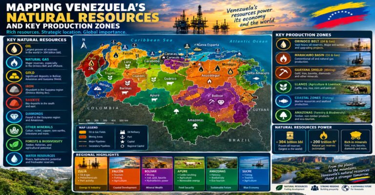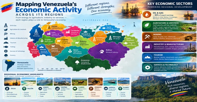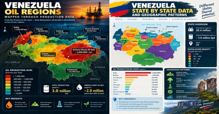
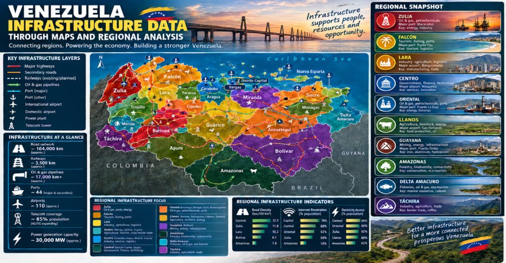
Venezuela Infrastructure Data Through Maps provides a practical way to understand how roads, railways, ports, airports, power facilities, water systems, telecommunications, cities, and industrial areas connect across the country. Instead of looking at infrastructure as a list of numbers, maps show where infrastructure is concentrated, which regions are connected, and where large geographic gaps remain. The World Bank’s infrastructure mapping tools use layers for transport, energy, digital networks, physical geography, cities, land cover, and economic activity, showing why a map-based approach is useful for studying Venezuela.
Venezuela is a large country with a highly varied physical landscape. The northern part contains most of the country’s major cities and many of its transport corridors. The central region includes the capital and important industrial and agricultural areas. The Llanos contain broad plains with agricultural, livestock, and energy activity. The south has enormous forests, major rivers, mineral deposits, and some of the country’s most important hydroelectric facilities.
This geographic pattern matters because infrastructure does not develop evenly across a country.
A highway connecting major cities serves a different purpose from a mining road in Bolivar. A petroleum pipeline has a different function from a passenger railway. A hydroelectric transmission line may connect a remote power station to an industrial centre hundreds of kilometres away.
That is why Venezuela Infrastructure Data Through Maps is most useful when different layers are viewed together.
A good infrastructure map can answer questions such as:
- Where are Venezuela’s main roads and highways?
- Which cities have the strongest transport connections?
- Where are the country’s railways located?
- Which ports connect Venezuela to international trade?
- Where are major airports concentrated?
- Which regions contain large power plants and transmission networks?
- Where are hydroelectric facilities located?
- How does infrastructure connect oil and mineral production zones?
- Which areas have strong digital connectivity?
- Where are infrastructure networks sparse or difficult to access?
- How do rivers, mountains, forests, and plains affect infrastructure development?
The World Bank’s country data page currently reports that Venezuela had a population of about 28.5 million in 2025. It also reports 100% access to electricity in 2024 and internet use by 77% of the population in the latest displayed series. These figures are useful starting points, but they should be read alongside geographic infrastructure data because national averages can hide large differences between regions.
Why Venezuela Infrastructure Data Through Maps Matters
Venezuela Infrastructure Data Through Maps turns infrastructure statistics into geographic information.
A table might tell us how many kilometers of roads exist. A map can show whether those roads connect major population centers, ports, agricultural areas, border crossings, or isolated communities.
The same principle applies to electricity.
A national electricity-access figure can look very high while a map of power generation and transmission tells a more detailed story about where electricity is produced and how it travels.
This distinction is important for researchers, students, businesses, journalists, planners, and anyone trying to understand Venezuela’s physical and economic geography.
What infrastructure maps can reveal
Infrastructure maps can reveal:
- Transport corridors between major cities
- Connections between mines and industrial centers
- Oil pipelines and petroleum infrastructure
- Railway corridors
- International ports and airports
- Hydroelectric facilities
- Transmission networks
- Telecommunications infrastructure
- Urban concentration
- Agricultural access
- Areas of geographic isolation
The World Bank’s Global Infrastructure Map includes layers for primary roads, all roads, railways, international airports, international ports, shipping density, power plants, dams, transmission and distribution, internet exchange points, submarine cables, mobile and broadband indicators, and access to cities.
That combination makes infrastructure mapping much more powerful than a single road map.
Venezuela Infrastructure Data Through Maps: A Geographic Overview
Venezuela Infrastructure Data Through Maps begins with geography.
Venezuela covers a large area between the Caribbean Sea, Colombia, Guyana, Brazil, and the Atlantic Ocean. Its terrain includes coastal plains, mountain ranges, broad grasslands, forests, river basins, and highlands.
These physical features strongly influence infrastructure.
The north has a high concentration of cities, industry, agriculture, and transport infrastructure. The south is much less densely settled and contains extensive forest and river systems.
The result is a national infrastructure pattern with a strong north-central concentration and much lower network density across parts of the south.
Northern Venezuela
Northern Venezuela contains many of the country’s largest urban and economic centers.
Important cities include:
- Caracas
- Maracaibo
- Valencia
- Barquisimeto
- Maracay
- Barcelona
- Puerto La Cruz
- Mérida
- San Cristóbal
- Puerto Cabello
Roads, airports, industrial facilities, ports, and telecommunications networks are generally more concentrated around these population centers.
The Caribbean coastline also creates opportunities for maritime transportation and international trade.
Central Venezuela
Central Venezuela contains the national capital and several major industrial and commercial corridors.
Caracas is the most important political and administrative center.
Nearby areas in Miranda, Aragua, Carabobo, and the Capital District form a major urban and industrial zone.
This region includes important:
- Highways
- Urban roads
- Airports
- Industrial parks
- Power infrastructure
- Telecommunications networks
- Ports and logistics facilities
The central region also benefits from its position between western and eastern Venezuela.
Western Venezuela
Western Venezuela includes Zulia and the Andean states.
This region has important petroleum infrastructure, agricultural areas, border connections, cities, and ports.
Lake Maracaibo is especially important because petroleum production created a large network of wells, pipelines, roads, storage facilities, terminals, and supporting services.
The Andes create a different infrastructure pattern.
Road construction is more difficult in mountainous terrain because of steep slopes, valleys, landslides, and winding routes.
Eastern Venezuela
Eastern Venezuela contains important oil and gas areas as well as major coastal and industrial centers.
Monagas and Anzoátegui are especially important to the petroleum economy.
The region also has connections to:
- Refineries
- Ports
- Gas pipelines
- Oil pipelines
- Industrial plants
- Airports
- Highways
Southern Venezuela
Southern Venezuela is geographically different from the densely populated north.
Bolívar and Amazonas contain large forest areas, major rivers, mineral deposits, and important hydroelectric resources.
Infrastructure is concentrated around specific industrial and mining corridors rather than forming a dense nationwide network.
Ciudad Guayana is the most important industrial center in the region.
Venezuela Infrastructure Data Through Maps: Roads and Highways
Roads are the backbone of Venezuela’s domestic transport system.
Venezuela Infrastructure Data Through Maps can show how road networks connect population centers with ports, industrial areas, agricultural regions, borders, and resource-producing zones.
The World Bank’s infrastructure mapping framework includes both primary roads and all-road layers. It also includes accessibility information that helps show how easily locations can reach cities.
Venezuela’s Main Road Pattern
The country’s main road network is concentrated largely in the north and central regions.
Major corridors connect:
- Caracas with central cities
- Caracas with western Venezuela
- Caracas with eastern Venezuela
- Valencia with central and western regions
- Barquisimeto with western and central areas
- Maracaibo with other parts of Zulia
- Eastern cities with petroleum-producing regions
These corridors support passenger movement and freight transportation.
Why roads are important for the economy
Roads connect production to markets.
A farm needs roads to move crops.
A mine needs roads to move machinery and supplies.
A factory needs roads to receive raw materials.
A port needs roads to move goods inland.
An airport needs road connections to serve passengers and cargo.
This makes road infrastructure a foundation for many other economic activities.
Mountain Roads
Mountain geography creates special challenges in western Venezuela.
The Andes contain steep slopes and narrow valleys.
Roads often need:
- Bridges
- Tunnels
- Retaining structures
- Switchbacks
- Drainage systems
- Slope protection
Weather can also affect mountain transportation.
Heavy rainfall can increase the risk of landslides and road damage.
For this reason, a road map should ideally be combined with elevation and rainfall layers.
The World Bank’s infrastructure map includes elevation, slope, climate-risk, and precipitation layers alongside transport infrastructure.
Venezuela Infrastructure Data Through Maps: Road Accessibility
A road network map does not tell the whole story.
Two communities can both appear near a road while having very different levels of accessibility.
One may be connected by a major highway.
The other may depend on a narrow local road that becomes difficult to use during heavy rain.
This is why accessibility mapping is valuable.
What accessibility maps show
Accessibility maps can estimate how easily people or businesses can reach:
- Cities
- Markets
- Ports
- Airports
- Hospitals
- Schools
- Industrial centers
- Employment areas
The World Bank’s infrastructure mapping system includes an “access to cities” layer specifically designed to help examine geographic accessibility.
This provides an important people-first perspective.
Infrastructure is not only about the number of roads.
It is also about whether people can actually use those roads to reach important services.
Venezuela Infrastructure Data Through Maps: Railway Network
Railways form a much smaller part of Venezuela’s transport system than roads.
However, railway infrastructure is important because rail can move large quantities of goods and passengers efficiently along suitable corridors.
Venezuela has developed railway projects and operational corridors over time, but its rail network has not reached the scale of its road system.
The World Bank’s infrastructure mapping framework includes railway layers and railway freight and passenger indicators among its transport datasets.
Important Railway Corridors
One of the country’s most significant railway projects is the central railway system connecting parts of the central region.
The railway network is particularly relevant around industrial and urban areas.
Mining and industrial railways also matter because bulk materials can require large-scale transport.
Why Railway Mapping Matters
A railway map can show relationships that are difficult to see on a road map.
For example, rail can connect:
- Mines to processing plants
- Industrial centers to ports
- Cities to suburban areas
- Agricultural zones to markets
Railway infrastructure is therefore closely linked with Venezuela’s industrial geography.
Venezuela Infrastructure Data Through Maps: Ports and Maritime Transport
Venezuela’s Caribbean and Atlantic coastline gives it direct access to maritime trade.
Ports are therefore a critical part of the national infrastructure system.
Major ports and maritime facilities are associated with large urban and industrial areas.
Important port locations include:
- La Guaira
- Puerto Cabello
- Maracaibo
- Puerto La Cruz
- Guanta
- Ciudad Guayana and the lower Orinoco system
The World Bank infrastructure mapping system includes international ports and shipping-density layers, allowing port infrastructure to be viewed alongside roads, railways, cities, and other networks.
Port of La Guaira
La Guaira serves the Caracas metropolitan area.
Its geographic importance comes from its position on the coast near the capital.
The port is connected to the interior through road infrastructure crossing mountainous terrain.
This makes the relationship between port and highway infrastructure especially important.
Puerto Cabello
Puerto Cabello is one of Venezuela’s major commercial ports.
Its location in Carabobo gives it a strong connection to the central industrial region.
It is positioned near important manufacturing, commercial, and agricultural areas.
Maracaibo
Maracaibo’s port infrastructure is closely connected to Lake Maracaibo and the petroleum economy of western Venezuela.
This gives maritime transport a different function from the major Caribbean commercial ports.
Guayana and the Orinoco
The lower Orinoco provides an important transport corridor for the Guayana industrial region.
This is particularly relevant for bulk commodities.
Iron and other mineral products can be moved through the river system toward downstream facilities and export routes.
Venezuela Infrastructure Data Through Maps: Airports
Air transport is another important infrastructure layer.
Venezuela has international airports, regional airports, and smaller airfields serving different geographic needs.
Major airports are concentrated around population centers and important economic regions.
Key airports include:
- Simón Bolívar International Airport near Caracas
- Arturo Michelena International Airport near Valencia
- La Chinita International Airport near Maracaibo
- Santiago Mariño International Airport on Margarita Island
- José Antonio Anzoátegui International Airport near Barcelona
- Manuel Carlos Piar International Airport near Puerto Ordaz
Airport maps help show how Venezuela connects major cities with domestic and international destinations.
Airports and Urban Geography
Airports are usually located near major population or economic centers.
Their location is influenced by:
- Available land
- Urban development
- Terrain
- Road access
- Aviation safety
- Passenger demand
- Cargo demand
Aviation infrastructure therefore adds another layer to the country’s urban geography.
Venezuela Infrastructure Data Through Maps: Energy Infrastructure
Energy infrastructure is one of the most important layers in Venezuela Infrastructure Data Through Maps.
The country has significant oil and gas resources as well as large hydroelectric capacity.
Its energy infrastructure includes:
- Oil fields
- Gas fields
- Refineries
- Pipelines
- Gas pipelines
- Power plants
- Hydroelectric dams
- Transmission lines
- Distribution networks
The World Bank’s infrastructure mapping system provides layers for power plants, dams, transmission and distribution, gas infrastructure, oil infrastructure, and electricity production by source.
Hydroelectric Infrastructure
Southern Venezuela is the center of the country’s most important hydroelectric infrastructure.
The Caroní River system is especially important.
Major facilities include:
- Guri
- Macagua
- Caruachi
These facilities are located in Bolívar state.
Guri and the Caroní River
Guri is one of the world’s major hydroelectric facilities.
Its location illustrates the relationship between physical geography and infrastructure.
Large rivers provide the water flow.
The terrain provides conditions for large reservoirs and dams.
Transmission infrastructure then carries electricity toward major population and industrial areas.
This is a classic example of why Venezuela Infrastructure Data Through Maps should combine physical and human geography.
A map can show the dam, river, transmission network, cities, and industrial centers together.
Venezuela Infrastructure Data Through Maps: Electricity Transmission
Electricity generation is only one part of the energy system.
Power must also travel from generation sites to consumers.
Transmission lines connect:
- Power stations
- Industrial centers
- Cities
- Distribution networks
- Regional grids
The geographic challenge is especially clear in Venezuela because some major hydroelectric facilities are located far from major northern population centers.
Transmission therefore creates a bridge between southern energy resources and northern demand.
Electricity Access and Infrastructure
The World Bank currently reports 100% access to electricity for Venezuela in its 2024 country data.
That national indicator should not be interpreted as proof that every community experiences identical reliability, service quality, or supply.
Access statistics answer a specific question about access.
They do not necessarily measure:
- Outage frequency
- Voltage quality
- Generation shortages
- Local grid condition
- Reliability
- Backup power
- Infrastructure age
For this reason, maps and engineering data provide useful context alongside national indicators.
Venezuela Infrastructure Data Through Maps: Oil and Gas Pipelines
Oil and gas infrastructure is strongly connected to Venezuela’s resource geography.
Pipelines link production fields with:
- Processing plants
- Refineries
- Storage terminals
- Export facilities
- Industrial consumers
The western oil system around Lake Maracaibo is one major example.
The Orinoco region is another.
Eastern Venezuela contains additional oil and gas infrastructure associated with Monagas and Anzoátegui.
Why Pipeline Maps Matter
Pipeline maps can reveal the hidden structure behind the petroleum economy.
An oil field may appear isolated on a resource map.
A pipeline map shows how that field connects to the rest of the industry.
This is particularly important for extra-heavy oil.
Production requires transportation and processing systems capable of handling the characteristics of the crude.
A resource map without infrastructure can therefore exaggerate the practical accessibility of a deposit.
Venezuela Infrastructure Data Through Maps: Water Infrastructure
Water infrastructure includes much more than rivers.
It includes:
- Reservoirs
- Dams
- Water treatment plants
- Distribution systems
- Irrigation networks
- Sewage systems
- Drainage infrastructure
Water infrastructure is especially important in urban areas.
Large cities require reliable systems to collect, treat, distribute, and manage water.
Agriculture also requires water management.
The World Bank infrastructure data framework includes freshwater and water-related indicators, while its map system allows water-related geographic layers to be viewed with physical and human geography.
Venezuela’s Water Geography
Venezuela has extensive river systems.
The Orinoco basin covers a large portion of the country.
Major rivers include:
- Orinoco
- Caroní
- Apure
- Arauca
- Meta
- Portuguesa
- Tuy
- Chama
- Cuyuní
However, water availability and population distribution do not perfectly match.
Large population centers are concentrated mainly in the north.
Some of the country’s largest rivers are in the south.
This creates a geographic infrastructure challenge.
Venezuela Infrastructure Data Through Maps: Irrigation
Irrigation is important for agriculture in areas where rainfall is seasonal or insufficient for some crops.
Mapping irrigation can show where agriculture depends on engineered water systems rather than rainfall alone.
FAO’s AQUASTAT database provides country-level information on irrigation and water resources and is one useful source for agricultural water mapping.
Irrigation infrastructure can include:
- Canals
- Reservoirs
- Pumping stations
- Wells
- Distribution pipes
- Farm-level systems
When irrigation maps are combined with road maps, they can show how agricultural production connects to markets.
Venezuela Infrastructure Data Through Maps: Telecommunications
Modern infrastructure is not only physical.
Digital networks are increasingly important to economic and social life.
Telecommunications infrastructure includes:
- Mobile networks
- Fiber-optic networks
- Internet exchange points
- Submarine cables
- Fixed broadband
- Data centers
- Cellular towers
The World Bank’s infrastructure map includes digital-network layers such as internet exchange points, submarine cables, and OpenCellID tower-density information. It also includes mobile and fixed-broadband indicators.
Internet Use in Venezuela
The World Bank currently reports internet use at about 77% of the population in its Venezuela country data.
Again, a national percentage does not show where network quality is strongest.
A map can show geographic differences in:
- Mobile tower density
- Fiber availability
- Broadband coverage
- Urban connectivity
- Remote-area access
This makes digital mapping an important part of modern infrastructure analysis.
Venezuela Infrastructure Data Through Maps: Mobile Networks
Mobile networks are particularly important because they can provide connectivity where fixed-line infrastructure is limited.
Cellular infrastructure usually follows population density.
Large cities tend to have greater network concentration.
Remote regions may have fewer towers because of:
- Low population density
- Difficult terrain
- Limited road access
- High construction costs
- Power availability
- Backhaul limitations
This creates a relationship between physical infrastructure and digital infrastructure.
A remote location that is difficult to reach by road can also be more expensive to connect to a telecommunications network.
Venezuela Infrastructure Data Through Maps: Submarine Cables
Venezuela’s location on the Caribbean coast makes submarine communications infrastructure geographically important.
Submarine cables carry large amounts of international internet and telecommunications traffic.
Cable landing points connect coastal infrastructure with inland networks.
This means that digital connectivity has a physical geography.
It depends on:
- Cable routes
- Landing stations
- Fiber networks
- Data centers
- Internet exchanges
- Electricity supply
A map can make this relationship easier to understand.
Venezuela Infrastructure Data Through Maps: Urban Infrastructure
Venezuela is highly urbanized.
This means infrastructure demand is concentrated around cities.
Urban infrastructure includes:
- Roads
- Public transport
- Water systems
- Sewage
- Electricity
- Telecommunications
- Airports
- Hospitals
- Schools
- Housing
- Waste management
The World Bank’s data platform provides urban and infrastructure indicators, while its map system includes global cities and administrative layers that can be combined with infrastructure networks.
Caracas
Caracas is the country’s largest metropolitan and administrative center.
Its infrastructure system includes extensive urban roads, public transportation, electricity, telecommunications, water systems, and connections to the main international airport.
The city’s mountain setting is important.
Caracas lies in a valley separated from the Caribbean coast by the Ávila mountain range.
This makes the Caracas–La Guaira connection particularly significant.
Maracaibo
Maracaibo is an important western urban and economic center.
Its infrastructure is closely connected with:
- Lake Maracaibo
- Petroleum
- Trade
- Agriculture
- Regional transport
Valencia
Valencia is a major central industrial and commercial center.
Its position in Carabobo places it near important highways, manufacturing areas, and Puerto Cabello.
Barquisimeto
Barquisimeto has a strategic position in central-western Venezuela.
It connects agricultural, commercial, and industrial regions.
Its location makes it important for inland logistics.
Ciudad Guayana
Ciudad Guayana is different from many northern cities.
Its importance is strongly linked to:
- Hydropower
- Iron ore
- Steel
- Aluminum
- River transport
- Industrial processing
It demonstrates how infrastructure can develop around natural resources.
Venezuela Infrastructure Data Through Maps: Industrial Corridors
Industrial corridors are geographic areas where roads, railways, power, ports, factories, and cities overlap.
Venezuela has several important examples.
Central industrial corridor
The central region around Caracas, Valencia, Maracay, and nearby areas contains major population and industrial activity.
Guayana industrial corridor
The Ciudad Guayana area connects:
- Hydropower
- Iron ore
- Steel
- Aluminum
- River transport
- Industrial facilities
Western petroleum corridor
The Lake Maracaibo and Zulia region contains petroleum production and associated transport infrastructure.
Eastern energy corridor
Monagas and Anzoátegui contain oil, gas, refining, petrochemical, and transport infrastructure.
Mapping these corridors helps explain why infrastructure investment is often concentrated in particular regions.
Venezuela Infrastructure Data Through Maps: Mining Infrastructure
Mining infrastructure is strongly concentrated in southern Venezuela.
The Guayana Shield contains major mineral resources.
Important commodities include:
- Iron ore
- Bauxite
- Gold
- Diamonds
- Other minerals
Mining infrastructure can include:
- Open-pit mines
- Underground mines
- Roads
- Railways
- Processing plants
- Smelters
- Power lines
- River terminals
The infrastructure pattern is therefore closely tied to geology.
A mine cannot simply be moved closer to a city.
Transport infrastructure has to reach the deposit.
Venezuela Infrastructure Data Through Maps: Agriculture and Logistics
Agricultural infrastructure connects farms with consumers.
It includes:
- Rural roads
- Irrigation
- Storage facilities
- Processing plants
- Markets
- Cold-chain systems
- Wholesale centers
- Ports
The Llanos are particularly important for livestock and agricultural production.
Roads are critical because much agricultural production occurs away from large cities.
The quality and reliability of rural transport can affect the cost of moving food from farms to markets.
Venezuela Infrastructure Data Through Maps: Border Connections
Venezuela shares land borders with:
- Colombia
- Brazil
- Guyana
Border infrastructure includes:
- Highways
- Bridges
- Border crossings
- Customs facilities
- Airports
- Trade routes
The Colombian border is especially important because Venezuela’s largest neighboring population and economic market is Colombia.
The Brazilian border is more sparsely populated and contains challenging terrain and extensive forest areas.
The Guyana border has a different geographic and political context, and infrastructure connectivity is less comparable to the major urban corridors in the north and west.
Venezuela Infrastructure Data Through Maps: The Colombia Connection
The western border with Colombia is an important transportation zone.
Road connections link cities and commercial areas on both sides.
The most important Venezuelan cities near the Colombian border include:
- San Cristóbal
- San Antonio del Táchira
- Maracaibo
- Machiques
The Táchira region is especially important because it connects the Venezuelan Andes with Colombia.
Mountain geography makes road infrastructure particularly important.
Venezuela Infrastructure Data Through Maps: The Brazil Connection
Southern border infrastructure is much less dense.
The border with Brazil passes through remote areas of forest and upland terrain.
Road connectivity is limited compared with the north.
This demonstrates an important principle:
Low infrastructure density does not necessarily mean low geographic importance.
Remote areas can contain:
- Forests
- Minerals
- Indigenous territories
- Rivers
- Biodiversity
- Border communities
Maps are essential for understanding these relationships.
Venezuela Infrastructure Data Through Maps: Natural Resources and Transport
Natural resources have strongly influenced the country’s infrastructure.
Oil created pipelines, refineries, terminals, roads, and ports.
Iron ore supported rail and industrial facilities.
Bauxite supported mining and aluminum processing.
Hydropower supported electricity transmission and industrial development.
Agriculture created rural road and irrigation requirements.
This means infrastructure and natural resources should be mapped together.
Oil Infrastructure
Oil infrastructure is concentrated around:
- Lake Maracaibo
- Orinoco Belt
- Monagas
- Anzoátegui
- Eastern offshore areas
Mineral Infrastructure
Mineral infrastructure is concentrated mainly in Bolívar.
Agricultural Infrastructure
Agricultural infrastructure is distributed across:
- Llanos
- Andes
- Central valleys
- Western plains
- Coastal agricultural areas
Energy Infrastructure
Major hydroelectric infrastructure is concentrated in southern Bolívar.
Venezuela Infrastructure Data Through Maps: Geographic Gaps
Infrastructure maps are useful not only for showing where networks exist.
They also show where networks are sparse.
Southern Venezuela is a clear example.
The region is large but has low population density compared with the north.
This makes dense road and utility networks more expensive to build and maintain.
Remote communities may therefore depend on:
- River transport
- Small roads
- Air transport
- Local electricity systems
- Mobile communications
- Small-scale infrastructure
A map can reveal these geographic differences much more clearly than a national average.
Venezuela Infrastructure Data Through Maps: Infrastructure and Population
Infrastructure usually follows population.
Large cities require dense networks.
Smaller towns need fewer roads, utilities, and services.
Remote settlements create different infrastructure challenges.
The World Bank’s latest country data place Venezuela’s population at approximately 28.5 million in 2025.
For infrastructure planning, however, the national population number is only the beginning.
Planners need to know:
- Where people live
- Where they work
- Where they travel
- Where they access services
- Where economic activity is concentrated
- How far communities are from major roads
- How far communities are from electricity networks
This is why population maps and infrastructure maps should be combined.
Venezuela Infrastructure Data Through Maps: Climate and Infrastructure Risk
Climate and terrain affect infrastructure performance.
Heavy rainfall can damage roads.
Flooding can affect bridges and low-lying communities.
Landslides can block mountain highways.
Drought can affect hydroelectric generation.
The World Bank’s infrastructure mapping system includes climate-risk layers for temperature and precipitation, along with elevation, slope, rivers, and infrastructure networks.
This allows users to examine infrastructure exposure rather than simply infrastructure location.
Flood Risk
Flooding can affect:
- Roads
- Bridges
- Railways
- Urban drainage
- Water systems
- Power facilities
Low-lying areas near rivers require careful planning.
Landslide Risk
Mountain roads are particularly exposed to slope instability.
The combination of steep terrain and heavy rainfall can increase maintenance requirements.
Drought and Hydropower
Hydroelectric systems depend on water availability.
Changes in rainfall and river flows can therefore affect electricity production.
This makes climate data an important companion to energy maps.
Venezuela Infrastructure Data Through Maps: The Role of GIS
GIS, or geographic information systems, allows different infrastructure layers to be combined.
A GIS map might contain:
- Roads
- Railways
- Ports
- Airports
- Power plants
- Transmission lines
- Cities
- Rivers
- Oil fields
- Mines
- Agricultural land
- Forests
Each layer provides a different piece of the story.
When they are combined, relationships become easier to see.
Example GIS Analysis
Suppose a researcher wants to identify the best-connected industrial areas.
They could overlay:
- Major roads
- Railways
- Ports
- Power plants
- Industrial centers
- Cities
The resulting map could identify clusters where several infrastructure systems overlap.
This is much more informative than looking at a road map alone.
Venezuela Infrastructure Data Through Maps: Data Sources
Good infrastructure analysis depends on good data.
The most useful sources include government agencies, international organizations, scientific institutions, and open geographic datasets.
World Bank
The World Bank provides country indicators and geospatial infrastructure datasets.
Its infrastructure mapping system includes transport, energy, digital networks, physical geography, economic geography, and other layers.
Its Venezuela country data also provide indicators for electricity, internet use, population, forests, freshwater, and other development measures.
OpenStreetMap
OpenStreetMap is useful for detailed mapping of:
- Roads
- Buildings
- Railways
- Airports
- Ports
- Bridges
- Local infrastructure
Because OpenStreetMap is continuously edited, data quality can vary by location.
Researchers should check the date and completeness of the relevant layer.
FAO
FAO is particularly useful for:
- Agriculture
- Irrigation
- Land use
- Water
- Food systems
- Rural infrastructure
Its AQUASTAT platform provides country-level water and irrigation information.
National and Sector Sources
Venezuelan government institutions can provide specialized information on:
- Roads
- Electricity
- Petroleum
- Mining
- Telecommunications
- Ports
- Airports
However, researchers should always check publication dates and definitions when comparing official figures across years.
Venezuela Infrastructure Data Through Maps: How to Read Data Correctly
Infrastructure statistics can be misleading when the definitions are unclear.
For example, “road length” may refer to:
- Total road network
- Paved roads
- Primary roads
- Public roads
- Roads in service
- Roads recorded in a particular database
Similarly, “electricity access” is different from electricity reliability.
“Internet use” is different from high-speed broadband coverage.
“Railway length” is different from active railway length.
Good analysis therefore requires careful attention to definitions.
Venezuela Infrastructure Data Through Maps: Current Versus Historical Data
Infrastructure changes over time.
A road built twenty years ago may have been upgraded, rerouted, or partially closed.
A railway may have changed its operating status.
A port may have different cargo volumes.
A power plant may have different operational capacity.
A telecommunications network can change rapidly.
This is why every map should include a data date.
For example:
- Road network, 2025
- Electricity access, 2024
- Internet use, 2025
- Forest cover, 2023
- Port traffic, specific reporting year
The World Bank country data page explicitly displays the year associated with individual indicators, which is important because the latest available year differs from one indicator to another.
Venezuela Infrastructure Data Through Maps: Understanding National Averages
National averages are useful but incomplete.
Consider electricity access.
The World Bank currently reports 100% electricity access for Venezuela in 2024.
That figure answers an access question.
It does not tell us whether:
- Every area receives the same service
- All households receive uninterrupted electricity
- Rural and urban networks have identical capacity
- Industrial users experience the same conditions
- Generation and transmission infrastructure have equal reliability
Maps can provide the geographic context needed to investigate those questions.
Venezuela Infrastructure Data Through Maps: Key Infrastructure Hubs
Several locations stand out as important infrastructure hubs because multiple networks meet there.
Caracas
Caracas is the main national political and urban hub.
It connects to:
- Central highways
- La Guaira
- Simón Bolívar International Airport
- Telecommunications networks
- Urban transport
- Electricity systems
Valencia and Puerto Cabello
This pair forms an important central logistics relationship.
Valencia provides access to industrial and commercial activity.
Puerto Cabello provides maritime access.
Maracaibo
Maracaibo combines:
- Urban infrastructure
- Petroleum infrastructure
- Lake transport
- Road networks
- Regional airport facilities
Ciudad Guayana
Ciudad Guayana combines:
- Hydropower
- Mining
- Steel
- Aluminum
- Roads
- River transport
- Industrial facilities
These hubs demonstrate why Venezuela Infrastructure Data Through Maps is best understood through connected networks rather than isolated facilities.
Venezuela Infrastructure Data Through Maps: Major Corridors to Watch
Several corridors are particularly important for understanding the country’s geography.
Caracas–La Guaira corridor
This connects the capital with its main international airport and Caribbean port area.
Caracas–Valencia corridor
This is a major central urban and industrial connection.
Valencia–Puerto Cabello corridor
This connects central industrial activity with maritime infrastructure.
Caracas–Barquisimeto corridor
This connects central Venezuela with the west.
Barquisimeto–Maracaibo corridor
This provides an important western connection.
Eastern petroleum corridors
These connect oil and gas production areas with industrial and coastal facilities.
Guayana–Orinoco corridor
This connects southern industrial activity with river transportation.
Venezuela Infrastructure Data Through Maps: Roads, Ports and Trade
Trade depends on several infrastructure systems working together.
A shipment may follow this path:
Factory → road → warehouse → port → ship
Another shipment might follow:
Mine → railway or road → river terminal → port → ship
Agricultural goods may follow:
Farm → rural road → regional market → city → consumer
These chains demonstrate why infrastructure mapping should focus on connections.
A port by itself is not a complete logistics system.
It needs roads, storage, customs facilities, cargo handling, electricity, water, telecommunications, and reliable connections to production areas.
Venezuela Infrastructure Data Through Maps: Digital Infrastructure and Economic Activity
Digital infrastructure increasingly supports physical infrastructure.
Ports need digital systems.
Airports need communications.
Power grids use telecommunications.
Banks and businesses depend on internet connectivity.
Government services increasingly use digital networks.
This creates a modern infrastructure system with two major layers:
- Physical networks
- Digital networks
The World Bank infrastructure map explicitly separates digital networks and digital services while also showing transport and energy infrastructure.
This makes it possible to study how physical and digital connectivity overlap.
Venezuela Infrastructure Data Through Maps: What the Maps Cannot Tell You
Maps are powerful, but they have limitations.
A map may show a road without telling you:
- Its condition
- Traffic level
- Maintenance status
- Average speed
- Safety
- Seasonal accessibility
A power map may show a plant without showing:
- Actual generation
- Maintenance status
- Outages
- Fuel availability
- Transmission constraints
A railway map may show tracks without showing:
- Passenger service
- Freight service
- Frequency
- Operating condition
This is why maps should be combined with statistics, field reports, satellite imagery, and official documentation.
Venezuela Infrastructure Data Through Maps: A Better Mapping Method
For a high-quality infrastructure study, use a layered approach.
Step 1: Map the population
Start with cities and population density.
Step 2: Map the physical geography
Add:
- Rivers
- Elevation
- Mountains
- Forests
- Plains
Step 3: Map transportation
Add:
- Roads
- Railways
- Ports
- Airports
Step 4: Map energy
Add:
- Power plants
- Dams
- Transmission lines
- Oil pipelines
- Gas pipelines
Step 5: Map economic activity
Add:
- Mines
- Oil fields
- Industrial zones
- Agricultural areas
- Major commodity sources
Step 6: Map digital connectivity
Add:
- Cellular towers
- Broadband
- Fiber
- Internet exchange points
- Submarine cable connections
Step 7: Map environmental constraints
Add:
- Protected areas
- Forests
- Flood zones
- Climate risks
- Sensitive ecosystems
This approach creates a much more complete picture of Venezuela’s infrastructure.
Venezuela Infrastructure Data Through Maps: Important Infrastructure Facts
Several current World Bank indicators provide useful national context.
- Venezuela’s population was reported at approximately 28.5 million in 2025.
- Electricity access was reported at 100% in 2024.
- Internet use was reported at about 77% in the latest displayed 2024 series.
- Forest area was about 52.2% of land area in 2023.
- Annual freshwater withdrawals were about 3% of internal resources in 2022.
These statistics should not be treated as substitutes for maps.
Instead, they provide national-level context for geographic analysis.
Venezuela Infrastructure Data Through Maps: What Researchers Should Watch
Researchers studying Venezuela’s infrastructure should pay attention to several areas.
Infrastructure condition
The existence of a network does not necessarily mean that it is operating at full capacity.
Regional differences
National statistics can hide differences between regions.
Data dates
Different indicators often come from different years.
Definitions
Terms such as “road,” “railway,” “electricity access,” and “internet use” can have specific meanings.
Geographic accuracy
A map’s boundary or infrastructure location may depend on the underlying dataset.
Data gaps
Some infrastructure information may be incomplete, outdated, or unavailable.
The World Bank itself notes that its map boundaries and geographic representations are illustrative and may not reflect official positions in every case.
Venezuela Infrastructure Data Through Maps: Future Infrastructure Planning
Infrastructure planning in Venezuela involves more than building new roads or power plants.
Future planning can involve:
- Maintaining existing roads
- Improving bridges
- Strengthening electricity transmission
- Expanding reliable digital access
- Improving water systems
- Modernizing ports
- Improving railway corridors
- Protecting critical infrastructure from climate risks
- Improving connections between rural areas and markets
The most effective planning begins with accurate geographic information.
Maps can help identify where infrastructure already exists and where important gaps remain.
Venezuela Infrastructure Data Through Maps: The Big Picture
When all major layers are combined, Venezuela’s infrastructure geography becomes easier to understand.
The country has a strong concentration of infrastructure in the north and central regions.
Major cities create dense transport and communications networks.
Oil-producing areas generate specialized energy infrastructure.
The Guayana region combines mining, hydropower, industrial facilities, roads, railways, and river transport.
The Llanos combine agriculture, livestock, roads, rivers, and selected petroleum infrastructure.
The Andes have more challenging terrain and transport corridors shaped by mountain geography.
Southern forest regions have much lower infrastructure density but contain major rivers, mineral resources, biodiversity, and hydropower potential.
This pattern explains why Venezuela Infrastructure Data Through Maps is more useful than a simple infrastructure inventory.
Frequently Asked Questions About Venezuela Infrastructure Data Through Maps
What is Venezuela Infrastructure Data Through Maps?
Venezuela Infrastructure Data Through Maps is a geographic approach to studying Venezuela’s roads, railways, ports, airports, power systems, water infrastructure, telecommunications, cities, and industrial networks.
Instead of looking at infrastructure only through tables, it uses maps to show where infrastructure is located and how different systems connect.
What are the main types of infrastructure in Venezuela?
The major categories include transport, energy, water, telecommunications, and urban infrastructure.
Transport includes roads, railways, airports, ports, and waterways.
Energy includes power plants, dams, transmission lines, pipelines, refineries, and petroleum facilities.
Digital infrastructure includes mobile networks, broadband, fiber networks, internet exchanges, and submarine cable connections.
Where is Venezuela’s infrastructure most concentrated?
Infrastructure is generally most concentrated in the northern and central parts of the country, where population and economic activity are also concentrated.
Major urban areas such as Caracas, Valencia, Maracaibo, Barquisimeto, Maracay, and eastern industrial centers have extensive infrastructure networks.
Where is Venezuela’s major energy infrastructure located?
Major hydroelectric infrastructure is concentrated in Bolívar state, particularly along the Caroní River.
Oil and gas infrastructure is concentrated in western, central-eastern, and eastern petroleum regions.
What is the importance of Ciudad Guayana?
Ciudad Guayana is a major industrial center connected to hydropower, iron ore, steel, aluminum, river transport, and other infrastructure.
Its location demonstrates how natural resources and infrastructure can reinforce each other.
What are Venezuela’s most important ports?
Important ports include La Guaira, Puerto Cabello, Maracaibo, Puerto La Cruz, and Guanta, along with river and industrial terminals associated with the Orinoco and Guayana region.
The exact importance of a port depends on the type of cargo, reporting period, and infrastructure capacity.
Does Venezuela have a large railway network?
Venezuela has railway infrastructure and railway projects, but its road system is much more extensive.
Railways remain important for selected passenger and industrial corridors.
How important are roads in Venezuela?
Roads are the main nationwide transport network and connect cities, production areas, ports, border crossings, and rural communities.
They are especially important because many areas do not have direct access to railway infrastructure.
How can maps help explain Venezuela’s infrastructure?
Maps can show relationships between infrastructure and geography.
For example, they can show how roads connect cities to ports, how pipelines connect oil fields to refineries, how transmission lines connect hydroelectric facilities to demand centers, and how digital networks follow population centers.
Where can I find Venezuela infrastructure data?
Useful sources include the World Bank’s Data platform and its infrastructure mapping tools, FAO databases for agricultural and water information, OpenStreetMap for geographic features, and specialized Venezuelan sector sources.
The World Bank’s infrastructure map provides layers for roads, railways, ports, airports, power plants, dams, transmission, digital networks, cities, land cover, rivers, and other geographic information.
Understanding Venezuela Through Infrastructure Maps
Venezuela Infrastructure Data Through Maps provides a clearer way to understand the country’s geography, economy, cities, natural resources, and regional connections.
The most important lesson is that infrastructure does not exist separately from geography.
Roads follow cities and economic corridors.
Ports follow coastlines and waterways.
Railways connect selected industrial and urban corridors.
Pipelines connect energy-producing regions with processing and export facilities.
Transmission lines connect power-generation areas with population and industrial centers.
Telecommunications networks increasingly follow population and economic activity.
Water infrastructure follows rivers, cities, farms, and industrial demand.
Mining infrastructure follows geology.
Agricultural infrastructure follows soils, climate, water, and markets.
This produces a complex geographic system.
The northern and central parts of Venezuela contain much of the country’s population and dense infrastructure networks. Western Venezuela is strongly shaped by Lake Maracaibo and petroleum. Eastern Venezuela contains important oil, gas, industrial, and coastal infrastructure. The Llanos combine agricultural, livestock, transport, and energy landscapes. Southern Venezuela contains major mineral and hydroelectric resources but generally has much lower infrastructure density.
For anyone researching Venezuela, the best approach is therefore not to ask only, “How much infrastructure does the country have?”
A better set of questions is:
- Where is the infrastructure?
- What does it connect?
- Who depends on it?
- Which resources does it support?
- What geographic barriers affect it?
- How old is the underlying data?
- Is the infrastructure active, planned, or historical?
- What environmental or climate risks affect it?
When these questions are answered with reliable data and layered maps, Venezuela Infrastructure Data Through Maps becomes more than an SEO keyword. It becomes a useful framework for understanding how Venezuela’s physical, economic, energy, transport, and digital systems fit together.
The World Bank’s infrastructure mapping platform is particularly useful because it brings many of these layers into one geographic framework, while its country data provide the national indicators needed to put individual infrastructure features into context.