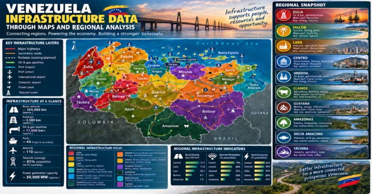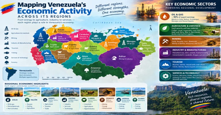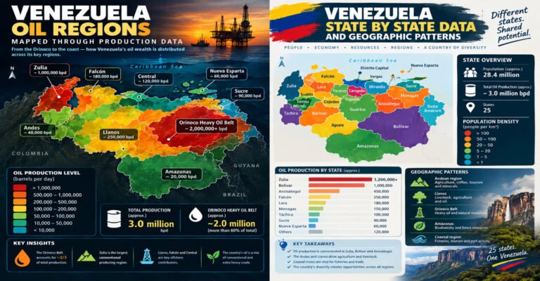
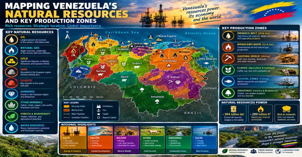
Mapping Venezuelas Natural Resources helps explain why Venezuela has long been one of the most resource-rich countries in South America. The country is known for its huge petroleum reserves, but its natural wealth goes far beyond oil. Venezuela also has natural gas, iron ore, bauxite, gold, coal, freshwater, forests, fertile agricultural land, fisheries, and major hydropower resources. These resources are spread across very different landscapes, from the oil fields around Lake Maracaibo and the Orinoco Belt to the mineral-rich Guiana Shield and the farming areas of the Llanos. Understanding where these resources are found makes it easier to understand Venezuela’s economy, industries, environment, trade, and regional importance.
Venezuela sits on the northern edge of South America. It faces the Caribbean Sea and the Atlantic Ocean and shares land borders with Colombia, Brazil, and Guyana. Its geography is unusually varied. The country includes high mountains, broad plains, tropical forests, major rivers, wetlands, coastal areas, islands, and offshore waters. FAO describes Venezuela as a country with Caribbean, Andean, Llanos, and Amazonian characteristics, which helps explain its wide range of natural resources.
The most important resource map begins with the country’s geology. Oil and gas are concentrated mainly in sedimentary basins. Iron ore, bauxite, gold, diamonds, and other minerals are strongly linked to the ancient rocks of the Guiana Shield. Agricultural resources are tied to climate, soils, water, and elevation. Hydropower is closely linked to major rivers, especially the Caroní system.
This guide looks at these resources region by region. It also explains the main production zones, why each zone matters, how resources are transported, and what environmental issues can affect their future.
Mapping Venezuelas Natural Resources: A Quick Overview
A natural-resource map of Venezuela can be divided into several major resource groups.
| Resource | Main areas or production zones | Why it matters |
|---|---|---|
| Petroleum | Orinoco Belt, Maracaibo Basin, eastern Venezuela | Main energy and export resource |
| Natural gas | Offshore areas, eastern Venezuela, associated gas fields | Energy and industrial feedstock |
| Iron ore | Bolívar State | Steel and metal production |
| Bauxite | Bolívar State | Aluminum industry |
| Gold | Bolívar State and Guiana Shield | Mining and precious-metal production |
| Diamonds | Guiana Shield | Gemstone and mineral resource |
| Coal | Zulia and western Venezuela | Fossil-fuel resource |
| Hydropower | Caroní River basin | Electricity generation |
| Agriculture | Llanos, Portuguesa, Barinas, Guárico, Zulia and other areas | Food and rural employment |
| Forests | Amazonas, Bolívar and southern Venezuela | Biodiversity, water, climate and forest products |
| Fisheries | Caribbean coast and offshore waters | Food, jobs and coastal trade |
The U.S. Energy Information Administration reported that Venezuela had about 303 billion barrels of proven crude oil reserves in 2023, the largest national total in the world at that time. Most of those reserves are extra-heavy crude located in the Orinoco Belt.
At the same time, the U.S. Geological Survey reports that Venezuela produced a range of mineral commodities, including bauxite, aluminum, gold, iron ore, iron and steel, cement, phosphate rock, and other industrial materials.
This difference between reserves and production is important. A country can have very large resources without producing them at the same level. Infrastructure, investment, technology, transport, market conditions, environmental limits, and policy can all affect production.
Mapping Venezuelas Natural Resources by Geographic Region
Venezuela’s resource geography becomes easier to understand when the country is divided into broad natural regions.
Mapping Venezuelas Natural Resources in the Maracaibo Region
The northwest is one of Venezuela’s most important petroleum regions.
Lake Maracaibo sits in a large sedimentary basin that has supported oil production for more than a century. The basin extends mainly through Zulia State and surrounding areas.
The region contains:
- Mature oil fields
- Oil wells
- Pipelines
- Storage facilities
- Processing infrastructure
- Refineries
- Ports
- Agricultural land
- Lake and wetland ecosystems
The city of Maracaibo grew into a major economic center partly because of the petroleum industry.
The Maracaibo Basin is different from the Orinoco Belt because its petroleum development has a much longer production history. Many fields are mature, meaning that maintaining production can require additional technology and investment.
Mapping Venezuelas Natural Resources in the Llanos
The Llanos are broad plains located south of Venezuela’s northern mountain systems.
This region is especially important for:
- Cattle
- Beef production
- Rice
- Maize
- Oil
- Natural gas
- Freshwater
- Grasslands
The Llanos extend across several states, including Apure, Barinas, Guárico, Cojedes, and Portuguesa.
Their broad, relatively flat landscapes make them suitable for agriculture and livestock. Seasonal rainfall and river systems strongly influence production.
FAO notes that Venezuela has strong agricultural potential for crops such as coffee, cocoa, palm oil, fruit, sugarcane, bananas, plantains, and cassava. It also identifies extensive pasture areas as important for beef and mixed livestock production.
Mapping Venezuelas Natural Resources in the Guiana Shield
Southern Venezuela contains some of the country’s most important mineral resources.
The Guiana Shield is an ancient geological formation extending across parts of Venezuela, Guyana, Suriname, French Guiana, and Brazil.
In Venezuela, it covers large parts of Bolívar and Amazonas states.
The region is important for:
- Iron ore
- Gold
- Bauxite
- Diamonds
- Other minerals
- Forests
- Freshwater
- Hydropower
- Biodiversity
The U.S. Geological Survey describes the Venezuelan Guiana Shield as an important mineral region containing gold, iron, bauxite, and diamonds.
The region is also environmentally important. FAO reports that the Guiana Shield area in Amazonas and Bolívar contains a large share of Venezuela’s forests and has major freshwater and biodiversity value.
Mapping Venezuelas Natural Resources Along the Caribbean Coast
Venezuela’s northern coastline adds another resource zone.
Coastal resources include:
- Fisheries
- Marine biodiversity
- Mangroves
- Wetlands
- Tourism
- Ports
- Offshore oil and gas
- Salt and other coastal resources
The coastline connects resource-producing regions to international markets.
This makes ports an important part of resource geography. Petroleum, minerals, agricultural goods, and other commodities need transportation networks to reach domestic and foreign markets.
Mapping Venezuelas Natural Resources: Petroleum Production Zones
Petroleum is the central part of Venezuela’s natural-resource story.
According to the U.S. Energy Information Administration, Venezuela had approximately 303 billion barrels of proven crude oil reserves in 2023. Most of these reserves consist of extra-heavy crude in the Orinoco Belt.
However, reserves and production are not the same thing.
Large reserves show how much oil is considered proven under defined conditions. Production shows how much oil is actually being extracted over a given period.
Venezuela’s production has been much lower than its enormous reserve base.
EIA reported that Venezuela produced only about 0.8% of global crude oil in 2023 despite having the world’s largest proven reserves.
Mapping Venezuelas Natural Resources in the Orinoco Oil Belt
The Orinoco Belt is the most important petroleum zone in the country when measured by reserves.
It lies south of the Orinoco River and stretches across a large part of eastern and central Venezuela.
The belt contains extra-heavy crude.
This crude has several important characteristics:
- It is very dense.
- It has high viscosity.
- It can require specialized production methods.
- It can require upgrading or blending.
- Transportation can be more difficult than for lighter crude.
The Orinoco Belt is commonly discussed through several major areas, including:
- Boyacá
- Junín
- Ayacucho
- Carabobo
These areas cover a very large territory.
The size of the belt explains why petroleum mapping must look beyond individual oil fields. Roads, pipelines, upgrading plants, storage sites, water systems, electricity, and worker settlements are all part of the wider production network.
Mapping Venezuelas Natural Resources in the Maracaibo Oil Basin
The Maracaibo Basin remains another major petroleum zone.
It is located in western Venezuela around Lake Maracaibo.
Oil development here has shaped the region’s economy, cities, transport systems, and industrial infrastructure.
The basin contains many mature fields.
That creates different challenges from those found in the newer or less-developed portions of the Orinoco Belt.
Mature fields may need:
- Enhanced recovery methods
- Well maintenance
- New drilling
- Pipeline repair
- Water management
- Improved monitoring
- Upgraded processing equipment
The condition of existing infrastructure can strongly affect how much petroleum a mature basin can produce.
Mapping Venezuelas Natural Resources in Eastern Venezuela
Eastern Venezuela also contains important petroleum and gas resources.
The eastern petroleum region includes parts of Anzoátegui and Monagas.
Monagas has long been associated with petroleum production and processing.
Anzoátegui also contains important petroleum infrastructure and industrial facilities.
This eastern corridor connects resource extraction with processing, transportation, and the Caribbean coast.
Mapping Venezuelas Natural Resources: Natural Gas Zones
Natural gas is another major energy resource.
EIA estimates that Venezuela had about 195 trillion cubic feet of natural gas reserves in 2023, equal to a large share of South America’s total gas reserves. Around 80% of Venezuelan gas production has historically been associated with oil production.
This means that oil and gas mapping are closely connected.
When an oil field produces crude, it can also produce natural gas.
That gas may be:
- Used at the production site
- Reinjected into oil fields
- Sent through pipelines
- Used by industry
- Used to generate electricity
- Processed for other purposes
EIA notes that a portion of Venezuela’s produced gas has been reinjected into oil fields to support crude production, while infrastructure limits have constrained broader gas development.
Mapping Venezuelas Natural Resources in Offshore Gas Areas
Venezuela also has significant offshore gas potential.
The country’s northern and eastern maritime areas contain sedimentary basins that can hold oil and gas.
Offshore development requires:
- Seismic surveys
- Drilling platforms
- Subsea equipment
- Pipelines
- Processing facilities
- Maritime support
- Environmental monitoring
Offshore resources can also overlap with fisheries and sensitive coastal ecosystems.
For that reason, a complete resource map should show both resource deposits and environmental zones.
Why Natural Gas Has Not Reached Its Full Potential
Large gas reserves do not automatically create large gas exports.
Several factors can affect development:
- Limited infrastructure
- Aging facilities
- Investment constraints
- Domestic demand
- Technical requirements
- Market access
- Regulatory conditions
- Export infrastructure
EIA identifies infrastructure limitations and investment conditions as important constraints on Venezuela’s gas sector.
Mapping Venezuelas Natural Resources: Iron Ore Zones
Iron ore is one of Venezuela’s most important non-fuel mineral resources.
Most major iron ore resources are associated with the Guiana Shield in Bolívar State.
Important iron ore areas include the wider Cerro Bolívar and San Isidro districts.
The region has geological formations containing large iron-rich deposits.
USGS research identifies deposits around Cerro Bolívar, San Isidro, and Los Barrancos among major iron formations in the Venezuelan Guiana Shield.
Mapping Venezuelas Natural Resources Around Cerro Bolívar
Cerro Bolívar became an important center of Venezuela’s iron industry.
The area contains high-grade iron formations.
Iron ore from this region historically supported:
- Mining
- Ore processing
- Steelmaking
- Rail transport
- Industrial development
The nearby city of Ciudad Guayana became a major industrial center partly because of the combination of mineral resources, river access, electricity, and transportation.
Mapping Venezuelas Natural Resources and the Iron Industry
Iron ore is only the first part of a larger industrial chain.
The chain can be viewed as:
Iron deposit → mine → processing → transportation → steel plant → manufactured products
Each stage needs energy and infrastructure.
That is why resource maps often show industrial centers near resource zones.
The Guayana region has a particularly important combination of iron ore and hydropower.
Mapping Venezuelas Natural Resources: Bauxite and Aluminum
Bauxite is the primary ore used to make aluminum.
Venezuela has important bauxite resources in Bolívar State.
The wider Guiana Shield provides the geological setting for these deposits.
The aluminum production chain generally includes:
- Bauxite mining
- Crushing and processing
- Alumina production
- Aluminum smelting
- Fabrication
Venezuela has historically developed an industrial system around these stages.
USGS production data show that Venezuela continued to produce bauxite, alumina, and primary aluminum in 2024, although production levels were much lower than historical capacity.
Mapping Venezuelas Natural Resources Around Los Pijiguaos
Los Pijiguaos in Bolívar State is one of Venezuela’s best-known bauxite-producing areas.
The resource is connected to the country’s wider aluminum industry.
Its location is important because raw materials need to move from mines to processing plants.
River transportation has historically played a role in moving material through the region.
The development of bauxite resources also shows why resource mapping needs to include transport corridors rather than only deposits.
Mapping Venezuelas Natural Resources: Gold Production Zones
Gold is another major mineral resource.
Most important gold resources are located in southern Venezuela, especially in Bolívar State.
The Guiana Shield contains geological structures favorable to gold mineralization.
Historically important gold districts include:
- El Callao
- Las Claritas
- Kilometer 88
- Other areas of Bolívar State
USGS research identifies El Callao as a historically important Venezuelan gold district.
Mapping Venezuelas Natural Resources in El Callao
El Callao is one of Venezuela’s best-known gold districts.
Gold mining in this area has a long history.
The district contains gold-bearing veins and other geological formations.
Its history demonstrates how mineral resources can support communities and economic activity over many generations.
At the same time, modern gold mining raises environmental concerns, especially where mining occurs outside well-regulated industrial operations.
Mapping Venezuelas Natural Resources and Informal Gold Mining
Gold mining in southern Venezuela has also expanded through informal and small-scale operations.
These activities can involve:
- River mining
- Forest clearing
- Soil disturbance
- Mercury use
- Sediment pollution
- New settlements
- Road construction
The environmental effects can spread beyond the mine itself.
For example, sediment entering a river can affect downstream ecosystems and communities.
A modern resource map should therefore show:
- Active mines
- Mining concessions
- Rivers
- Indigenous territories
- Protected areas
- Forest cover
- Roads
- Settlements
This provides a much clearer picture than simply showing gold deposits.
Mapping Venezuelas Natural Resources: Diamonds and Other Minerals
The Guiana Shield contains more than gold and iron.
Venezuela also has deposits or occurrences of:
- Diamonds
- Nickel
- Copper
- Coltan-related minerals
- Manganese
- Quartz
- Other industrial minerals
The exact size and economic importance of some deposits can be difficult to measure because mineral data are not always updated at the same rate.
USGS notes that reliable production estimates are not available for every mineral commodity.
Mapping Venezuelas Natural Resources and Diamond Zones
Diamond-bearing areas occur mainly in the Guiana Shield.
Some diamond deposits are associated with river systems and alluvial environments.
This creates a strong relationship between geology and waterways.
However, river-based mining can disturb river channels and increase sediment loads.
That makes environmental monitoring important.
Mapping Venezuelas Natural Resources: Coal
Coal is another fossil resource found in Venezuela.
Important coal resources occur in western Venezuela, particularly in Zulia State.
Coal has historically been considered an additional energy and export resource, although petroleum and natural gas have dominated Venezuela’s energy economy.
Coal deposits need to be evaluated according to:
- Deposit quality
- Depth
- Transport costs
- Market demand
- Mining costs
- Environmental effects
- Competition from other energy sources
A resource may be geologically large but economically less important than another resource.
Mapping Venezuelas Natural Resources: Hydropower
Venezuela has major hydropower potential because of its large rivers and highland terrain.
The Caroní River is particularly important.
The Caroní flows through Bolívar State and is a major tributary of the Orinoco.
FAO describes the Caroní basin as strategically important for water and hydroelectric energy as well as biodiversity and mineral resources.
Mapping Venezuelas Natural Resources Around the Caroní River
The Caroní basin is one of the most important energy zones in Venezuela.
Its geography provides strong river flows and elevation changes that can support hydropower generation.
Major infrastructure in the basin has made the region central to Venezuela’s electricity system.
The basin also supports:
- Freshwater
- Forests
- Wildlife
- Indigenous communities
- Fisheries
- Recreation
- Agriculture in suitable areas
This makes the Caroní a good example of why natural resources cannot always be separated into individual categories.
One river can simultaneously be:
- A water resource
- An energy resource
- An ecological resource
- A transport resource
- A community resource
Mapping Venezuelas Natural Resources and the Guri Area
The Guri hydroelectric complex is located on the Caroní River.
It became one of the country’s most important electricity-generation facilities.
Its electricity has supported large industrial operations in Bolívar State, including the aluminum and steel sectors.
This creates a powerful geographic connection:
Water → Hydropower → Industry → Employment → Urban development
The same resource system also creates environmental responsibilities.
Changes in rainfall, drought, sediment, watershed health, and climate can influence hydropower generation.
Mapping Venezuelas Natural Resources: Forest Resources
Venezuela has extensive forests, particularly in the south.
The states of Amazonas and Bolívar contain large areas of tropical forest.
FAO reports that the Guiana Shield region in Venezuela contains a major share of the country’s forests and is highly important for biodiversity and freshwater.
Forests are natural resources even when they are not harvested for timber.
They provide:
- Clean water
- Carbon storage
- Wildlife habitat
- Soil protection
- Food
- Medicines
- Forest products
- Cultural value
- Tourism opportunities
Mapping Venezuelas Natural Resources in Amazonas
Amazonas State contains large areas of tropical forest and river systems.
The region is less industrialized than the northern parts of the country.
Its natural-resource value is therefore strongly linked to:
- Biodiversity
- Freshwater
- Forest ecosystems
- Indigenous communities
- Ecotourism
- Traditional livelihoods
The resource map of Amazonas should not focus only on extractive commodities.
In many areas, keeping forests intact can itself be an important economic and ecological objective.
Mapping Venezuelas Natural Resources and Indigenous Territories
Indigenous peoples live in several resource-rich areas of southern Venezuela.
Their territories can overlap with:
- Forests
- Rivers
- Mining areas
- Protected areas
- Mineral deposits
This makes community participation important when mapping and managing natural resources.
A good resource map should answer not only “What is here?” but also:
- Who lives here?
- Who uses the land?
- What ecosystems are present?
- What legal protections apply?
- What activities are already taking place?
Mapping Venezuelas Natural Resources: Agricultural Zones
Agriculture is an important part of Venezuela’s natural-resource geography.
Unlike oil and minerals, agricultural resources can be renewed when land, water, soil, and ecosystems are managed well.
FAO identifies Venezuela’s diverse climates and landscapes as providing opportunities for tropical crops, livestock, horticulture, and fisheries.
Important agricultural zones include parts of:
- Portuguesa
- Guárico
- Barinas
- Cojedes
- Zulia
- Lara
- Aragua
- Yaracuy
- Mérida
- Táchira
Mapping Venezuelas Natural Resources in Portuguesa
Portuguesa is one of Venezuela’s important agricultural states.
The region is especially associated with crop production.
Important crops include:
- Rice
- Maize
- Sugarcane
- Other food crops
FAO’s recent country reporting identifies Portuguesa, Guárico, and Barinas as major areas for maize production and identifies Portuguesa, Guárico, Barinas, and Cojedes among important rice-producing regions.
Mapping Venezuelas Natural Resources in Guárico
Guárico is part of the Llanos.
Its broad plains support agriculture and livestock.
The state also contains areas associated with oil and gas resources.
This makes Guárico a good example of a region where different resource systems overlap.
Agricultural land and petroleum infrastructure can exist within the same broad geographic area.
Mapping Venezuelas Natural Resources in Barinas
Barinas combines agricultural land, grasslands, river systems, and petroleum resources.
The state is known for cattle production and crop agriculture.
Its position near the Andes also creates varied landscapes and climates.
This geographic diversity supports different types of farming.
Mapping Venezuelas Natural Resources: Rice Production
Rice needs suitable soils, water, and relatively flat land.
Venezuela’s Llanos provide favorable conditions in several areas.
Important rice-producing states include:
- Portuguesa
- Guárico
- Barinas
- Cojedes
FAO’s 2025 country brief identifies these areas among Venezuela’s main rice-producing regions.
Rice production also shows the importance of water management.
Farmers need reliable water during critical growing periods.
Too much rain can also create problems.
Flooding can damage crops, roads, storage areas, and rural infrastructure.
Mapping Venezuelas Natural Resources: Maize Production
Maize is another important crop.
The main production areas include the central-western agricultural zone.
FAO reports that Portuguesa, Guárico, and Barinas are major maize-producing areas.
Maize production depends on:
- Rainfall
- Soil fertility
- Seeds
- Fertilizer
- Fuel
- Machinery
- Roads
- Storage
- Market access
Therefore, an agricultural resource map should include infrastructure as well as farmland.
Mapping Venezuelas Natural Resources: Coffee and Cocoa
Venezuela also has areas suitable for specialty crops such as coffee and cocoa.
These crops are strongly influenced by elevation and climate.
Coffee production is often linked to mountainous areas.
Cocoa performs well in warmer and more humid regions.
FAO identifies coffee and cocoa among crops with potential in Venezuela’s diverse agroecological environment.
Mapping Venezuelas Natural Resources in the Andes
The Venezuelan Andes are concentrated mainly in the west.
The mountain environment supports:
- Coffee
- Vegetables
- Fruit
- Livestock
- Tourism
- Freshwater resources
Higher elevations create cooler conditions than the hot lowlands.
This allows crops that need different temperatures to be grown in specific zones.
The Andes also act as important water towers because rainfall and mountain runoff feed rivers.
Mapping Venezuelas Natural Resources: Fisheries
Venezuela has access to both Caribbean and Atlantic waters.
This gives it a significant marine resource base.
Fisheries can include:
- Tuna
- Sardines
- Shrimp
- Other marine fish
- Shellfish
Coastal fishing supports many communities.
Marine resources also connect with ports, food processing, tourism, and trade.
Mapping Venezuelas Natural Resources in Coastal Wetlands
Wetlands are particularly important because they support both people and ecosystems.
They can:
- Store water
- Reduce flood impacts
- Support fish
- Provide bird habitat
- Store carbon
- Protect coastlines
FAO reported in 2026 that Venezuelan coastal communities and institutions were working on the protection and management of important coastal wetlands.
This shows that wetlands should be treated as valuable natural infrastructure rather than empty land.
Mapping Venezuelas Natural Resources: Freshwater
Venezuela has a large network of rivers and lakes.
The most important water systems include:
- Orinoco River
- Caroní River
- Apure River
- Meta-related drainage systems
- Lake Maracaibo
- Orinoco Delta waterways
Freshwater supports almost every other resource sector.
Agriculture needs water.
Mining needs water.
Cities need water.
Hydropower needs rivers.
Forests protect watersheds.
Fisheries depend on healthy aquatic ecosystems.
Mapping Venezuelas Natural Resources Along the Orinoco River
The Orinoco is the country’s largest river system and one of the most important rivers in South America.
It drains a huge part of Venezuela.
The river is connected to:
- Agriculture
- Fisheries
- Transportation
- Hydropower
- Mining
- Forest ecosystems
- Wetlands
- Indigenous communities
The Orinoco also forms a major geographic divide between northern and southern resource regions.
The petroleum-rich Orinoco Belt lies largely south of the river.
The mineral-rich Guiana Shield also lies mainly south of the river.
This makes the Orinoco central to understanding Venezuela’s resource geography.
Mapping Venezuelas Natural Resources: The Orinoco Delta
The Orinoco Delta is an extensive wetland and river environment.
It contains:
- Mangroves
- Wetlands
- Rivers
- Forests
- Fisheries
- Wildlife
- Indigenous communities
The delta is also important for the movement of water and sediment into the Atlantic.
Resource development in upstream regions can affect downstream environments.
For example, mining can increase sediment loads, while agricultural runoff can affect water quality.
This is why resource mapping needs a watershed approach.
Mapping Venezuelas Natural Resources and Environmental Protection
Natural resources can create economic opportunities, but resource development can also create environmental pressure.
The main concerns vary by resource.
Oil and Gas Environmental Issues
Oil development can create risks involving:
- Oil spills
- Produced water
- Gas flaring
- Pipeline leaks
- Soil contamination
- Habitat fragmentation
The condition of old infrastructure can be especially important in mature oil-producing areas.
Mapping Venezuelas Natural Resources and Mining Impacts
Mining can affect:
- Forest cover
- Rivers
- Soil
- Wildlife
- Local communities
Gold mining can be especially difficult to manage when operations are informal or remote.
Potential impacts include:
- Deforestation
- River sediment
- Mercury pollution
- Habitat loss
- Erosion
These impacts are not limited to the mine site.
They can move downstream through connected river systems.
Mapping Venezuelas Natural Resources and Forest Loss
Forest loss can result from several activities.
These may include:
- Mining
- Agriculture
- Roads
- Settlements
- Illegal logging
- Infrastructure development
The Guiana Shield is particularly important because of its biodiversity and freshwater resources.
FAO has identified biodiversity conservation and sustainable resource management as important priorities in Venezuela’s southern regions.
Mapping Venezuelas Natural Resources and Climate Change
Climate change adds another layer to resource planning.
Changes in rainfall can affect:
- Hydropower
- Agriculture
- Forests
- Rivers
- Wetlands
- Fisheries
Drought can reduce river flows.
Heavy rainfall can cause floods and landslides.
FAO has identified drought and climate-related pressure as threats to crops, forests, rivers, and wildlife in the Caroní basin.
Mapping Venezuelas Natural Resources During Drought
Drought can create a chain of effects.
For example:
Less rainfall → lower river flows → lower hydropower potential → pressure on electricity supply
The same drought can affect farming:
Less rainfall → less soil moisture → lower crop yields → higher food pressure
This is why water resources should be included in every major resource map.
Mapping Venezuelas Natural Resources and Infrastructure
Resources have little economic value if they cannot reach markets.
Infrastructure is therefore an important part of natural-resource geography.
Important infrastructure includes:
- Roads
- Railways
- Pipelines
- Ports
- Power lines
- Refineries
- Processing plants
- Storage facilities
- River transport
Mapping Venezuelas Natural Resources and Oil Pipelines
Oil pipelines connect producing areas with refineries, storage facilities, and ports.
The most important pipeline networks are associated with the major petroleum-producing basins.
Pipeline maps help show:
- Where oil is produced
- Where it is processed
- Where it is stored
- Where it is exported
They can also reveal potential environmental risks.
A pipeline crossing a river, wetland, or populated area requires different monitoring from one crossing an isolated landscape.
Mapping Venezuelas Natural Resources and Mining Transport
Mining regions in southern Venezuela face different transport challenges.
Some areas are remote.
Road infrastructure can be limited.
Rivers can provide transportation routes.
Industrial centers such as Ciudad Guayana developed partly because they combine resource access with transport and electricity.
Mapping Venezuelas Natural Resources and Ciudad Guayana
Ciudad Guayana is one of the clearest examples of a resource-based industrial city.
Its location near the Orinoco and Caroní rivers provides access to:
- Water
- Hydropower
- Iron ore
- Bauxite
- Industrial infrastructure
- River transportation
The city became a major center for steel, aluminum, and other industries.
This shows how resource geography can influence urban geography.
A resource deposit can lead to:
Mine → infrastructure → factory → workers → city growth
Mapping Venezuelas Natural Resources and Refineries
Petroleum production is only one stage of the energy system.
Refineries transform crude oil into usable products.
Venezuela has historically had a large refining system.
Important refining infrastructure has been located in areas such as:
- Zulia
- Falcón
- Anzoátegui
The Paraguaná area in Falcón is particularly important to Venezuela’s refining geography.
Refineries need:
- Crude supply
- Water
- Electricity
- Storage
- Transportation
- Maintenance
- Export connections
Therefore, refining centers are often located near both petroleum-producing regions and coastal transportation routes.
Mapping Venezuelas Natural Resources: Production Versus Reserves
One of the most important ideas in resource geography is the difference between reserves and production.
A reserve is not the same as annual output.
For example, Venezuela can have enormous oil reserves while producing much less oil than its historical levels.
EIA’s data show this difference clearly. Venezuela held about 303 billion barrels of proven crude oil reserves in 2023, while its share of global crude production was only about 0.8%.
The same principle applies to minerals.
A geological deposit does not guarantee that a mine will operate at full capacity.
Production can be limited by:
- Capital
- Equipment
- Electricity
- Roads
- Labor
- Technology
- Prices
- Regulation
- Environmental restrictions
Mapping Venezuelas Natural Resources and the Role of Technology
Modern resource mapping uses more than paper maps.
Today, researchers can use:
- Satellite images
- Geographic information systems
- Aerial photography
- Geological surveys
- Remote sensing
- GPS
- Drone imagery
- River monitoring
- Soil data
- Climate data
Satellite data can help identify changes in:
- Forest cover
- Mining areas
- Oil infrastructure
- Agricultural land
- Wetlands
- Rivers
Mapping Venezuelas Natural Resources With GIS
A Geographic Information System, or GIS, allows different layers to be placed on one map.
For Venezuela, useful GIS layers could include:
- Oil fields
- Gas fields
- Mineral deposits
- Mines
- Rivers
- Forests
- Farms
- Roads
- Cities
- Protected areas
- Indigenous territories
- Ports
- Pipelines
- Power plants
- Rainfall
- Elevation
Putting these layers together creates a much more useful picture of the country’s resource geography.
Mapping Venezuelas Natural Resources by State
A state-by-state view can also help readers understand resource distribution.
Mapping Venezuelas Natural Resources in Bolívar State
Bolívar is arguably one of the most diverse resource regions in Venezuela.
It contains:
- Iron ore
- Gold
- Bauxite
- Diamonds
- Hydropower
- Forests
- Rivers
- Biodiversity
The Caroní basin is especially important.
Bolívar also contains major industrial facilities around Ciudad Guayana.
Mapping Venezuelas Natural Resources in Zulia State
Zulia is strongly associated with petroleum.
Lake Maracaibo and the surrounding basin form the center of the region’s oil geography.
Zulia also contains:
- Agriculture
- Livestock
- Fisheries
- Natural gas
- Lake resources
Mapping Venezuelas Natural Resources in Anzoátegui
Anzoátegui is important for:
- Petroleum
- Natural gas
- Refining and processing
- Industry
- Coastal resources
- Agriculture
Its location gives it access to both inland resources and the Caribbean.
Mapping Venezuelas Natural Resources in Monagas
Monagas is another major petroleum region.
The state contains oil fields and supporting infrastructure.
Its economy has historically been closely connected to the energy sector.
Mapping Venezuelas Natural Resources in Portuguesa
Portuguesa is one of the country’s leading agricultural areas.
Important production includes:
- Rice
- Maize
- Other crops
FAO identifies Portuguesa as a major agricultural production area.
Mapping Venezuelas Natural Resources in Guárico
Guárico combines agricultural and energy resources.
It is part of the Llanos.
Important activities include:
- Cattle
- Crops
- Oil
- Natural gas
Mapping Venezuelas Natural Resources in Barinas
Barinas is associated with:
- Agriculture
- Cattle
- Oil
- Rivers
- Grasslands
Its location between the Llanos and Andes gives it varied environmental conditions.
Mapping Venezuelas Natural Resources in Amazonas
Amazonas is dominated by forest and river systems.
Its most important natural assets include:
- Forests
- Freshwater
- Biodiversity
- Wildlife
- Indigenous cultural resources
Resource management here must give strong attention to conservation and community rights.
Mapping Venezuelas Natural Resources in Falcón
Falcón is important for:
- Petroleum refining
- Coastal resources
- Fisheries
- Agriculture
- Tourism
- Salt and other mineral resources
The Paraguaná Peninsula is particularly important in Venezuela’s energy infrastructure.
Mapping Venezuelas Natural Resources and the Orinoco Mining Arc
The Orinoco Mining Arc is a large area in southern Venezuela designated for mineral development.
It includes parts of Bolívar, Amazonas, Delta Amacuro, and other areas depending on the specific administrative definition used.
The zone has been associated with resources such as:
- Gold
- Iron
- Bauxite
- Diamonds
- Coltan
- Other minerals
However, the area has also generated concerns about environmental damage, informal mining, forest loss, and impacts on communities.
This makes the Orinoco Mining Arc an important case study in the balance between resource development and environmental protection.
Mapping Venezuelas Natural Resources and Biodiversity
Venezuela’s biodiversity is itself a major natural asset.
FAO identifies Venezuela as one of the world’s megadiverse countries.
The country contains many different ecosystems.
These include:
- Tropical forests
- Savannas
- Wetlands
- Mountains
- Coastal ecosystems
- Rivers
- Mangroves
- Marine habitats
Biodiversity supports:
- Tourism
- Fisheries
- Agriculture
- Water systems
- Research
- Cultural heritage
- Ecosystem services
Mapping Venezuelas Natural Resources in Canaima
Canaima National Park in Bolívar is one of Venezuela’s most important protected landscapes.
It is known for:
- Tepuis
- Waterfalls
- Rivers
- Forests
- Unique species
- Indigenous communities
The landscape is valuable even where there is no large-scale industrial production.
This highlights an important principle:
Natural resources are not only things that can be mined or sold.
A forest, river, wetland, or landscape can have major economic and social value without being extracted.
Mapping Venezuelas Natural Resources and Tourism
Tourism is closely linked to natural geography.
Venezuela’s natural attractions include:
- Angel Falls
- Canaima
- Tepuis
- Caribbean beaches
- Los Roques
- Andes mountains
- Llanos wildlife
- Orinoco Delta
- Coastal wetlands
Tourism can provide economic value while creating incentives to protect landscapes.
However, tourism also needs infrastructure and careful management.
Too much development can damage the very ecosystems that attract visitors.
Mapping Venezuelas Natural Resources and Renewable Energy
Venezuela’s energy future does not have to depend only on fossil fuels.
The country also has potential for:
- Hydropower
- Solar power
- Wind power
- Biomass
Hydropower is already the most important renewable electricity resource.
Solar potential is especially relevant in areas with strong sunlight.
Wind potential can be important along certain coastal and northeastern areas.
Biomass can be connected to agricultural residues.
Mapping Venezuelas Natural Resources for Solar Energy
Solar resource maps can identify areas with high solar radiation.
Such maps can help locate:
- Solar farms
- Rural power systems
- Distributed solar
- Agricultural pumping
- Remote community electricity systems
Solar energy can be particularly useful where grid connections are weak or expensive.
Mapping Venezuelas Natural Resources for Wind Energy
Wind resources vary considerably by geography.
Coastal and northeastern areas can have stronger wind conditions.
Wind development requires detailed measurements.
A useful wind map would include:
- Wind speed
- Wind direction
- Elevation
- Roads
- Transmission lines
- Protected areas
- Settlements
Mapping Venezuelas Natural Resources and Food Security
Natural resources are directly connected to food security.
Agricultural land produces food.
Rivers provide irrigation.
Fisheries provide protein.
Forests can provide food and livelihoods.
Livestock depends on pasture and water.
FAO’s work in Venezuela places food security, rural livelihoods, sustainable food systems, biodiversity, and natural-resource management among its key areas of cooperation.
This means resource mapping can also be used to answer practical questions about food production.
For example:
- Where are the main crop areas?
- Which regions depend on irrigation?
- Where are cattle concentrated?
- Which rivers support agriculture?
- Which coastal areas support fisheries?
- Which regions face drought risk?
Mapping Venezuelas Natural Resources and Water Security
Water security is becoming increasingly important.
A country with abundant rivers can still experience local water shortages.
The reasons can include:
- Seasonal rainfall
- Drought
- Pollution
- Infrastructure problems
- Unequal distribution
- Population growth
- Climate change
The Caroní basin shows the close link between water and energy.
The Orinoco system shows the link between water, transportation, fisheries, agriculture, and ecosystems.
Lake Maracaibo shows the importance of managing a large inland water body within a heavily developed resource region.
Mapping Venezuelas Natural Resources and Economic Dependence
Venezuela’s economy has long been heavily dependent on hydrocarbons.
Oil has generated a large share of export earnings and government revenue over many decades.
That dependence creates both benefits and risks.
When oil prices are high, petroleum income can increase.
When prices fall, revenues can decline.
Production disruptions can also affect the wider economy.
EIA describes petroleum as a major source of Venezuelan government revenue and notes that constraints in investment, infrastructure, and technical capacity have affected the energy sector.
Mapping Venezuelas Natural Resources and Economic Diversification
Resource diversification means developing several sectors instead of depending heavily on one.
Possible sectors include:
- Agriculture
- Food processing
- Mining
- Manufacturing
- Tourism
- Fisheries
- Renewable energy
- Petrochemicals
- Forestry
- Technology
Diversification does not mean abandoning existing resources.
It means creating more than one source of economic activity.
Mapping Venezuelas Natural Resources and Export Infrastructure
Natural resources often travel long distances before reaching consumers.
A simplified petroleum chain looks like this:
Oil field → pipeline → storage → refinery or port → international market
A mineral chain may look like this:
Mine → processing plant → railway or road → industrial center or port → market
Agriculture has a similar chain:
Farm → collection center → road → processing → market
These connections show why infrastructure is part of resource mapping.
Mapping Venezuelas Natural Resources: Major Production Zones at a Glance
The most important production zones can be summarized as follows.
Western Petroleum Zone
Main areas:
- Zulia
- Lake Maracaibo
- Maracaibo Basin
Main resources:
- Petroleum
- Natural gas
- Fisheries
- Agriculture
Orinoco Petroleum Zone
Main areas:
- Anzoátegui
- Monagas
- Guárico
- Bolívar
Main resources:
- Extra-heavy oil
- Natural gas
- Related industrial resources
Guayana Mineral Zone
Main area:
- Bolívar
- Parts of Amazonas
Main resources:
- Iron
- Gold
- Bauxite
- Diamonds
- Hydropower
- Forests
Central Agricultural Zone
Main areas:
- Portuguesa
- Guárico
- Barinas
- Cojedes
Main resources:
- Rice
- Maize
- Cattle
- Other crops
Andean Agricultural Zone
Main areas:
- Mérida
- Táchira
- Trujillo
Main resources:
- Coffee
- Vegetables
- Fruits
- Livestock
- Freshwater
Caribbean Coastal Zone
Main areas:
- Falcón
- Sucre
- Nueva Esparta
- Coastal areas of several other states
Main resources:
- Fisheries
- Tourism
- Marine ecosystems
- Offshore energy
- Coastal agriculture
Mapping Venezuelas Natural Resources: Why Location Matters
The location of a resource affects its value.
An oil deposit near pipelines and roads may be easier to develop than a similar deposit in a remote region.
An iron deposit near hydropower and railways can support an industrial complex.
A farm near irrigation and roads can reach markets more easily.
A forest far from roads may remain relatively intact.
This is why natural-resource geography is really about relationships.
The key question is not simply:
Where is the resource?
It is:
Where is the resource, and what surrounds it?
Mapping Venezuelas Natural Resources With Satellite Technology
Satellite technology can improve resource monitoring.
Satellites can detect changes in land cover over time.
For example, repeated images can help identify:
- New mining sites
- Forest clearing
- Expanding farms
- Oil infrastructure
- Reservoir changes
- Flooding
- Drought
- Coastal changes
This is especially useful in remote areas.
Southern Venezuela has large areas where field surveys can be difficult.
Remote sensing can provide a broader view.
Mapping Venezuelas Natural Resources and Data Challenges
Accurate mapping requires reliable data.
That can be difficult when:
- Production data are delayed
- Informal mining is not fully recorded
- Infrastructure changes quickly
- Older geological surveys remain in use
- Different organizations use different definitions
- Economic conditions change rapidly
USGS explicitly notes that available production information is insufficient for reliable estimates for some Venezuelan mineral commodities.
This is why responsible resource reporting should identify the source and year of important statistics.
A number from 2010 should not be presented as a 2026 production figure.
Mapping Venezuelas Natural Resources: Reserves, Resources, and Potential
Three terms are often confused.
Resources are naturally occurring materials that may have economic value.
Reserves are resources considered economically recoverable under defined conditions.
Potential refers to possible resources that may require more exploration or development before their value is confirmed.
These distinctions matter.
For example, a geological survey can identify a mineralized area.
That does not mean a commercial mine already exists.
Likewise, a country’s huge petroleum reserves do not tell us how much oil is produced each year.
Mapping Venezuelas Natural Resources and Sustainable Development
Sustainable resource management means using natural resources while protecting the ability of future generations to benefit from them.
For Venezuela, this can include:
- Better mine monitoring
- Cleaner mining technology
- Reduced oil spills
- Improved pipeline maintenance
- Forest conservation
- Watershed protection
- Sustainable agriculture
- Responsible fisheries
- Renewable energy
- Community participation
The goal is not simply to produce more.
It is to understand the full cost and value of production.
Mapping Venezuelas Natural Resources: The Future of Key Production Zones
The future of Venezuela’s production zones will depend on several factors.
Oil and Gas
The Orinoco Belt is likely to remain central to Venezuela’s petroleum geography because of its enormous reserve base.
However, development depends on:
- Investment
- Infrastructure
- Technology
- Production capacity
- Market access
- Policy
- International conditions
Mining
The Guiana Shield will remain important because of its mineral wealth.
The main challenge is balancing mineral development with:
- Forest protection
- Water quality
- Biodiversity
- Indigenous rights
- Responsible mining practices
Agriculture
Agriculture has opportunities in areas such as:
- Portuguesa
- Guárico
- Barinas
- Cojedes
- Zulia
- Andean states
Improving roads, irrigation, storage, seeds, farm inputs, and market access can influence agricultural output.
Hydropower
The Caroní basin will remain important to Venezuela’s electricity system.
Its future depends on:
- Rainfall
- Reservoir management
- Infrastructure maintenance
- Climate conditions
- Watershed protection
Mapping Venezuelas Natural Resources: A Practical Resource Map
A simple national resource map could use the following structure.
Northwest
- Petroleum
- Natural gas
- Agriculture
- Lake resources
Central Llanos
- Cattle
- Rice
- Maize
- Oil
- Natural gas
East
- Petroleum
- Natural gas
- Coastal resources
South
- Iron
- Gold
- Bauxite
- Diamonds
- Hydropower
- Forests
Andes
- Coffee
- Vegetables
- Fruits
- Livestock
- Freshwater
Caribbean Coast
- Fisheries
- Tourism
- Wetlands
- Offshore resources
This simple structure makes Venezuela’s resource geography easier to understand.
Mapping Venezuelas Natural Resources: Key Takeaways
Venezuela’s natural-resource wealth is spread across several major geographic systems.
The most important points are:
- Petroleum is concentrated mainly in major sedimentary basins.
- The Orinoco Belt contains most of the country’s enormous proven oil reserves.
- Lake Maracaibo and western Venezuela form a historic petroleum region.
- Eastern Venezuela contains important oil and gas production zones.
- Bolívar State is central to iron, bauxite, gold, and other mineral resources.
- The Caroní River supports major hydropower generation.
- The Llanos are important for agriculture and livestock.
- Portuguesa, Guárico, Barinas, and Cojedes are important crop-producing areas.
- Amazonas and southern Bolívar contain extensive forests and freshwater resources.
- Venezuela’s Caribbean and Atlantic waters support fisheries and coastal ecosystems.
- Natural-resource development is closely linked to roads, pipelines, ports, electricity, and processing facilities.
- Environmental protection is especially important in the Guiana Shield, river basins, wetlands, and coastal ecosystems.
The country’s resource geography is therefore highly connected.
Oil needs pipelines.
Mines need transportation.
Factories need electricity.
Farms need water.
Cities need food and energy.
Forests protect watersheds.
Rivers support power, ecosystems, agriculture, and communities.
Understanding these relationships is the real value of Mapping Venezuelas Natural Resources.
Mapping Venezuelas Natural Resources: People Also Ask
What are Venezuela’s main natural resources?
Venezuela’s major natural resources include petroleum, natural gas, iron ore, gold, bauxite, coal, diamonds, freshwater, forests, agricultural land, fisheries, and hydropower. Petroleum is by far the most internationally important resource because Venezuela has an exceptionally large proven crude oil reserve base. EIA reported approximately 303 billion barrels of proven crude oil reserves in 2023.
Where are Venezuela’s oil reserves located?
Most of Venezuela’s proven oil reserves are located in the Orinoco Belt. Other important petroleum resources occur in the Maracaibo Basin in western Venezuela and in eastern parts of the country.
What is the Orinoco Belt?
The Orinoco Belt is a large petroleum-producing region south of the Orinoco River. It contains extensive deposits of extra-heavy crude oil and represents the largest concentration of Venezuela’s proven oil reserves.
Where is gold found in Venezuela?
Gold resources are concentrated mainly in southern Venezuela, particularly Bolívar State and the wider Guiana Shield. El Callao is one of the country’s historically important gold districts.
Where is iron ore found in Venezuela?
Important iron ore deposits occur in Bolívar State within the Guiana Shield. Areas associated with Cerro Bolívar, San Isidro, and Los Barrancos are historically important parts of Venezuela’s iron-ore geography.
Where is bauxite found in Venezuela?
Important bauxite deposits occur in Bolívar State, including the Los Pijiguaos area. Bauxite supports the country’s aluminum production chain.
What is Venezuela’s most important natural resource?
Petroleum has historically been Venezuela’s most important natural resource in economic and export terms. However, the country also has major mineral, water, agricultural, forest, fisheries, and hydropower resources.
Does Venezuela have natural gas?
Yes. Venezuela has very large natural gas reserves. EIA estimated about 195 trillion cubic feet of natural gas reserves in 2023. Much of the country’s gas production is associated with oil production.
Why is the Caroní River important?
The Caroní River is important for hydropower, freshwater, biodiversity, and industrial development. Its basin contains major hydroelectric infrastructure and is closely linked to the industrial economy of Bolívar State. FAO describes the river as strategically important for water and hydroelectric energy.
What crops does Venezuela produce?
Venezuela produces a variety of crops, including maize, rice, coffee, cocoa, sugarcane, bananas, plantains, cassava, fruits, and vegetables. Production varies by region. FAO identifies Portuguesa, Guárico, Barinas, and Cojedes among important cereal-producing areas.
What is Venezuela’s main agricultural region?
The Llanos and central-western agricultural areas are among the country’s important farming regions. Portuguesa, Guárico, Barinas, and Cojedes are especially relevant for crop production, while other regions support coffee, cocoa, livestock, fruits, and vegetables.
Why is Bolívar State important?
Bolívar State contains a remarkable combination of mineral and energy resources. These include iron ore, gold, bauxite, diamonds, rivers, hydropower, forests, and biodiversity. The region also contains major industrial infrastructure around Ciudad Guayana.
What is the Guiana Shield?
The Guiana Shield is an ancient geological region covering parts of northern South America. In Venezuela, it forms the geological foundation for many important mineral deposits, including iron, gold, bauxite, and diamonds.
What environmental problems are linked to mining?
Mining can cause forest loss, soil disturbance, erosion, river sediment, water pollution, and habitat loss. Gold mining can create additional concerns where mercury is used or where operations occur outside formal regulatory systems.
Why is the Orinoco River important to Venezuela?
The Orinoco River is important for freshwater, ecosystems, fisheries, transportation, agriculture, wetlands, and connections between northern and southern parts of the country. Its basin also overlaps with major petroleum and mineral-resource zones.
Does Venezuela have renewable energy resources?
Yes. Hydropower is especially important, with the Caroní basin supporting major electricity generation. Venezuela also has potential for solar, wind, and biomass energy.
Mapping Venezuelas Natural Resources: People Also Search For
Readers researching Venezuela’s resource geography commonly look for related topics such as:
- Venezuela oil reserves
- Orinoco Belt oil
- Venezuela natural gas reserves
- Venezuela gold mining
- Venezuela iron ore
- Venezuela bauxite
- Venezuela mineral resources
- Venezuela mining map
- Venezuela oil fields map
- Maracaibo oil basin
- Orinoco River resources
- Guiana Shield Venezuela
- Venezuela agricultural regions
- Venezuela farming areas
- Venezuela hydropower
- Caroní River
- Guri Dam
- Venezuela forests
- Venezuela freshwater resources
- Venezuela fisheries
- Venezuela coal reserves
- Venezuela diamond deposits
- Venezuela natural resources map
- Venezuela major exports
- Venezuela petroleum production
- Venezuela mineral production zones
These related searches reflect a common need: people want to understand not only what Venezuela has, but where those resources are located and how they connect to the country’s economy.
Mapping Venezuelas Natural Resources: How to Read a Resource Map
When reading a natural-resource map, start with the geology.
Oil and gas tend to occur in sedimentary basins.
Iron, gold, and bauxite are closely connected to ancient geological formations.
Agricultural resources are linked to soils, rainfall, temperature, and water.
Hydropower depends on rivers and elevation.
Forests depend on climate, soil, and land-use history.
Then look at infrastructure.
A mine without a road is different from a mine near a railway.
An oil field without a pipeline faces different challenges from one connected to a refinery.
A farm near a highway has easier market access than a remote farm.
Finally, look at people and ecosystems.
Resource zones are not empty spaces.
They contain communities, wildlife, forests, rivers, cultural sites, farms, and protected areas.
Mapping Venezuelas Natural Resources: Why Accurate Sources Matter
Natural-resource information changes over time.
Production numbers can change each year.
Reserve estimates can be revised.
New geological studies can change resource estimates.
Mining activity can expand or decline.
Agricultural production can respond to weather and input prices.
Because of this, good resource writing should identify the date and source of major statistics.
For energy information, the U.S. Energy Information Administration provides useful country-level analysis.
For mineral production, the U.S. Geological Survey provides commodity information and production tables.
For agriculture, forests, biodiversity, water, and food systems, the Food and Agriculture Organization provides country and regional information.
Using different authoritative sources is better than relying on a single old resource list.
Mapping Venezuelas Natural Resources: Final Perspective
Venezuela is often described simply as an oil-rich country. That description is true but incomplete.
A fuller map reveals several overlapping resource systems.
The western petroleum basin around Lake Maracaibo has a long history of oil production.
The Orinoco Belt contains an enormous concentration of extra-heavy crude.
Eastern states such as Anzoátegui and Monagas contribute to the country’s oil and gas geography.
The Llanos provide large agricultural and livestock areas.
Bolívar State contains major iron, gold, bauxite, diamond, water, forest, and hydropower resources.
Amazonas contains extensive forests, rivers, and biodiversity.
The Caribbean coast provides fisheries, wetlands, tourism, and access to offshore resources.
The Andes support agriculture and important watersheds.
These regions are connected by roads, rivers, pipelines, ports, power lines, industrial centers, and cities.
That is why Mapping Venezuelas Natural Resources is more than locating oil wells or mineral deposits. It is a way to understand how geography, geology, water, agriculture, energy, industry, ecosystems, infrastructure, and communities fit together.
The country’s enormous resource base provides significant opportunities, but the scale of those opportunities should not be confused with current production. EIA’s data demonstrate this clearly for petroleum: Venezuela’s proven oil reserves are enormous, yet its production has been much smaller relative to its reserve base.
The same lesson applies to minerals. Venezuela has important deposits of iron, bauxite, gold, and other minerals, but actual production depends on infrastructure, technology, investment, regulation, market conditions, and environmental factors. USGS data show that Venezuela remained a producer of several mineral commodities in 2024, while also noting gaps in reliable data for some commodities.
The future of Venezuela’s natural resources will therefore depend not only on what lies beneath the ground, but also on how the country manages the land and water above it.
A strong resource strategy needs accurate maps.
It needs reliable data.
It needs modern infrastructure.
It needs responsible environmental management.
It needs attention to agricultural and water systems.
And it needs to recognize the people and communities who live in resource-rich areas.
When all of these factors are considered together, Venezuela’s natural-resource geography becomes much easier to understand.
Mapping Venezuelas Natural Resources ultimately shows a country where oil, gas, minerals, agriculture, forests, water, energy, fisheries, and biodiversity are deeply connected. The key production zones are different from one another, but together they form the geographic foundation of Venezuela’s economy and environmental future.